Symposium 13a: The History of Cartography
[= 1st International Conference on the History of Cartography]
17-18 July 1964 — London
 The original symposium, or, as we have since come to know it, the First International Conference on the History of Cartography, was held at the House of the Royal Geographical Sociey June 17-18, 1964.1 The price of registration was £1, and, according to the 1967 report, exactly 58 participants showed, out of 73 who had registered. Ten countries were represented among the papers’ authors, Argentina, Belgium, France, Germany, Ireland, Japan, The Netherlands, Portugal, United Kingdom, United States, so the 1st ICHC was indeed very much international.
The symposium was in two sections, the first “Studies of Individual Maps, Cartographers, or Map-Groups,” and the second “Methodology and Interpretation.”
There were 23 papers, all listed below here, although but 17 were actually read. The papers of Jacoby, Levillier, Muroga, Oehme, Smet and Winter were read by title only, since their authors were unable to attend. The works of all but Herve, Jacoby, Levillier, Muroga, Oehme, Smet, Smith and Winter, were published in full in Imago Mundi, 19 (1965), and that journal has played a major part in the conferences to the present time.2 Three more papers, those of Jacoby, Levillier, and Winter, were printed there in abstract, and Smith’s paper was printed, revised and enlarged, in Imago Mundi, 20 (1966).
The papers were followed by an open discussion, “The History of Cartography, present state and future prospects.” (The discussion is well covered in the 1967 report, pp. 257-59), followed by a formal presentation of some recent publications, and finally the closing remarks, by Cornelis Koeman. Although I have not been able to find it so stated anywhere, probably full copies of all the original papers were deposited in the RGS Library, for that was done for the second conference, held, like the first, at the RGS.3
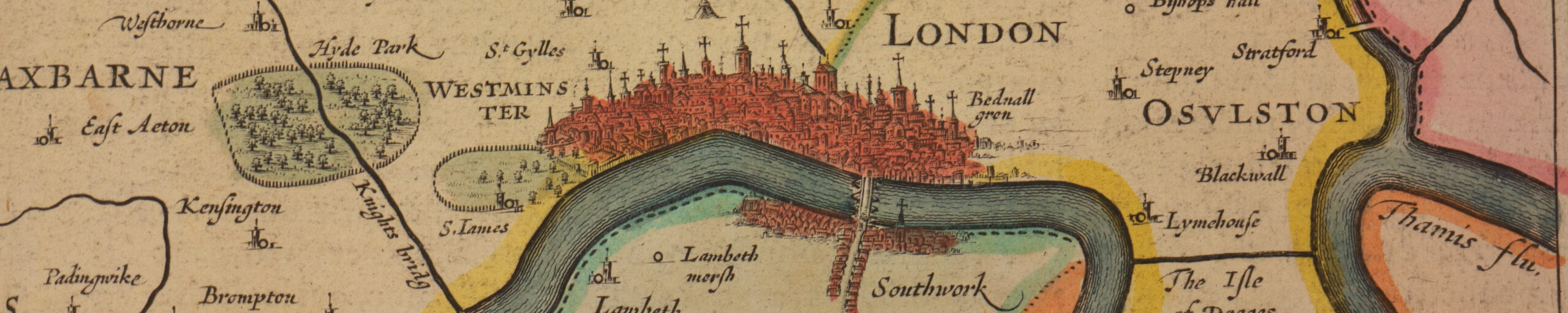
This first conference was essentially a no-frills gathering, without the auxiliary activities, such as specialist group meetings, excursions, receptions and exhibitions which characterized later ICHCs. However, there were several exhibitions connected with the 20th IGC of interest to a map historian, and two of them, organized by Skelton and Crone, while officially adjuncts of the larger congress and not of the symposium, can in spirit be considered as related to the latter, and as the forerunners of the exhibits which have accompanied all ICHCs since. They were “The Growth of London A.D. 43 to 1964,” in the Victoria and Albert Museum from July 17 to August 30, and “The Mapping of Britain, 13th to 19th Centuries,” in the King’s Library of the British Museum for the same dates.4
Papers 1st ICHC
- J.H. Andrews (IE). A Hitherto Unnoticed Map by Robert Lythe. (14pp) (in Wood as: The Irish Surveys of Robert Lythe.–same paper?)
- Armando Cortesão (PT). An Early Chorographic Map of Portugal. (5pp)
- Marcel Destombes (FR). The Mappamundi in the Poem Alexandreidos by Guatierede Châtillon c. 1180.
- Myriem Foncin (FR). Une carte économique manuscrite de la France (fin XVIIIe siècle).
- Herman R. Friis (US). The Development and Status of Geographical and Cartographic Activities of the United States Government, 1812-18. (13pp) (Wood ends title “1776-1818,” which is probably correct.
- J. Brian Harley (GB).The Remapping of England 1750-1800. (This work does not occur in the 1964 book of abstracts (s. note 7 above), although there are there two Harley Works from both of which material was probably taken for the present work.)
- G. A. Hayes-McCoy (IE). Contemporary Maps as an Aid to Irish History, 1593-1603.
- Roger Hervé (FR). Du noveau sur le probleme cartographique de la “Grande Jave”: le planisphère de Guillaume Brouscon de 1543.
- Gustav Jacoby (DE). The Mile Used by Lucas Waghenaer in 1583 and Some Questions in Connection with it. (7pp) (This was actually originally published in German in the Dutch periodical Tijdschrift van het Koninklijk Nederlandsch Aardrijkskundig Genootschap, ser. 2, vol. 55 (1938), 877-81, though perhaps less developed, and there was also an enlarged English edition of 1947, although it is unclear whether or not that was published (s. Wood, p. 30, no. 10).)
- George Kish (US). The Cosmographic Heart: Cordiform Maps of the 16th Century. (9pp)
- Cornelis Koeman (NL).The Wall-Map of Europe of 1595 by Jodocus Hondius. (6pp)
- M. de La Roncière (FR). Cartes manuscrites (1699-1701) de l’hydrographie de l’East India Company, John Thornton.
- Roberto Levillier (AR). Mapping of the Portuguese Voyage of 1501-1502, and Vespucci’s Account. (Although the title given in Wood is quite different, “Map Placenames and their Lessons,” (31pp), one suspects that it is the same, or essentially the same, paper.)
- Nobuo Muroga (JP). Early Hemispheric World Maps in Japan.
- Ruthardt Oehme (DE). Maps of South-West Germany in the Swedish Military Archives.
- John Parker (US). A Fragment of a 15th-Century Planisphere in the James Ford Bell Collection.
- Antoine de Smet (BE). La Carte de Cabinet ou Carte manuscrite des Pays-Bas Autrichiens du Général Joseph de Ferraris 1771-1778 et son interet pour l’histoire de la Belgique. (8pp)
- T. R. Smith IGB). The Juan de la Cruz Cano Map of South America, Madrid, 1771-75: The Internal Evidence of its States and Publication. (13pp)
- Boleslaw Boym Szczesniak (PL). The Boym Map of China.
- A.B. Taylor (GB). Name Studies in 16th-Century Scottish Maps. (10pp)
- Coolie Verner (US). The Identification and Designation of Variants in the Study of Early Printed Maps.
- Helen Wallis (GB). The Influence of Ricci on Far Eastern Cartography. (13pp)
- Heinrich Winter (DE).The Mechanical Effect of the Medieval “Astrolabium Nauticum,” Being an Instrument for the Designing of Sea-Charts and Worldmaps. (2pp)
Note
In the 1964 abstracts volume (s. footnote 1), there are given two other history of cartography works, to wit:
- Smith, Thomas R. The Work of Nicholas Cumberford, Seventeenth-Century Chart-Maker of London;
- Woodward, D. A. A History of Topographic Mapping in Africa;
as well as still five others relevant to some degree:
- Friis, Herman R. The Image of the American West at Mid-Century (1840-1860);
- Friis, Herman R. Matthew Fontaine Maury’s Contributions to Geography: 1842-1861;
- Gedymin, A. V., and A. T. Khritonycheva. Old Cartographic Material Used in Landscape Study;
- Griffith, D. L., and J. J. Kelly. Producing Ordnance-Survey Quarter-Inch Maps;
- Harley, J. B. The Evaluation of Historical Evidence on British County Maps.
However, these were not part of the symposium, and perhaps were not read at all at the congress, since none are mentioned in the register of papers read at the 20th IGC in the 1967 Proceedings (s. note 4 above), pp. 95-125, except the first Friis paper (at p. 96). Perhaps some of them were originally intended for the cancelled “History of Cartography” sub-section under the IGC section “Cartography” (s. p. 1 above).
Footnotes:
- The fullest report is: G. R. Crone, R. A. Skelton, and Helen Wallis, “Symposium 13a: The History of Cartography,” in the 1967 proceedings (s. Watson in note 4 of introduction), pp. 251-59, which includes full resumes of all papers read as well as the discussions. Other facts can be gleaned from Imago Mundi 18 (1964), p. 91a (in the “Chronicle”), Imago Mundi 37 (1985), p. 82 (in Crone biography by Wallis); Imago Mundi 40 (1988), p. 56 (a note on the origin of the ICHCs); and the second 20th IGC circular (see note 3 of introduction), p. 59, and Alberta Auringer Wood, Professional Papers, Correspondence, etc., of Raleigh Ashlin (Peter) Skelton (1906-1970): Collection 59 in the Centre for Newfoundland Studies Archives in the Memorial University of Newfoundland Library, St. John’s (St. John’s, Nfld., 1989, pp. 27-31.The 20th International Geographical Congress, Abstracts of Papers, ed. F. E. Ian Hamilton (London, 1964) includes abstracts of all the symposium papers, including those which were not read. As noted in Hamilton’s preface, a different classification for the papers was devised for the abstracts book than was used in the congress itself and, although there is a section there for “History of Cartography” (pp. 21-26), which does include most of the symposium papers, a few of those have ended up in other sections, while a few foreign papers from other sections have got included. Finally, the titles of papers as given in George Kish, ed., Bibliography of International Geographical Congresses 1871-1976 (Series of Studies of the History of Geography, 1) (Boston, 1979), pp. 239-85, unfortunately also follow the classifications of the abstracts book.
- See the official Imago Mundi guidelines for ICHC organizers here.
- Full copies of twelve of them are also preserved in the Skelton archives at the Memorial University of Newfoundland (Wood (s. note 1 above), pp. 29-30), including three of those not published, Jacoby, De Smet, and Winter, and possibly also that of Levillier, although the title given for his paper in Wood disagrees with that given in the 1967 report. There should exist copies of all, for in the guidelines for presenters on p. 54 of the second circular it was stated: “The author of a paper to be read at a Symposium should send in advance an additional 75 copies of the paper for distribution among members attending the Symposium in question.”
- See full-page reports of them in the 1967 proceedings, p. 198 and p. 199 respectively, by Skelton. For the “Growth of London” exhibition an extensive catalog was published: The Growth of London AD 43-1964: Catalogue of an Exhibition at the Victoria & Albert Museum 17 July-30 August 1964 (London, 1964). The second of these exhibitions may be considered as corollary to Crone’s article “The Mapping of the British Isles,” in The British Isles: A Systematic Geography, ed. J. Wreford Watson, et al (London, 1964), pp. 40-52, which book was distributed to all members of the big congress.