Dissertaties Historische Kartografie / Theses History of Cartography
Marco van Egmond
Covens & Mortier
Production, organisation and development of a commercial cartographic publishing house in Amsterdam, 1685-1866
Diss. Utrecht 31 mei 2005
Terug naar overzicht dissertaties / Back to overview PhD-theses
English Summary
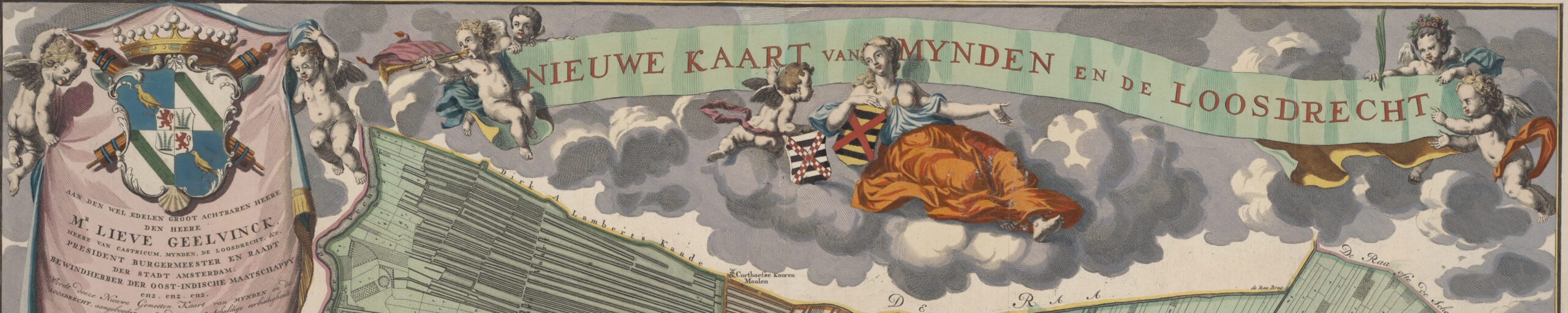
Production, organisation and development of a commercial cartographic publishing house in Amsterdam, 1685-1866
In the 18th century and during a large part of the 19th century, the largest and most important Dutch publishing house in the field of commercial cartography was the Amsterdam firm of Covens & Mortier. With respect to quantity it was possibly even the biggest contemporary map-trading house worldwide.
With only minor exaggeration, one could suggest that the history of map trading in the 18th and 19th century is mainly a matter of blank pages still. Indeed, a good overview of the development of commercial cartography in general and of the commercial cartography enterprises specifically of those days is lacking until now. The image of Dutch commercial cartography after about 1675, as it emerges from literature, is that of a trend following trade. Innovations mainly took place abroad, first in France, later in England and Germany. Only a marginal role was reserved for map trading in The Netherlands during the 18th and 19th centuries.
The present thesis attempts to put to the test the development of this image of commercial cartography. In addition, it intends to supply arguments for other future commercial-cartographic monographs.
This thesis focuses on the significance of the Amsterdam publishing house of Covens & Mortier for the evolution of Dutch commercial cartography during the 18th and 19th century. Hereby, a three-pronged problem is used as a starting point:
- What was the composition of the cartographic portfolio of Covens & Mortier; how about quantity and quality of the maps so produced?
- In what manner was the firm Covens & Mortier organized as a commercial-cartographic enterprise; along which lines ran the process of collection, production and distribution of the map material?
- How did the firm of Covens & Mortier contribute to the national and international development of commercial cartography in the 18th and 19th centuries?
1. Theory and commercial cartography
What applies in general to the history of cartography is even more valid to the subpart of history of commercial cartography: theoretical considerations hardly play a role. Research into commercial cartography may, however, benefit from a model-concept. Such a model would offer a simplified rendition of potential relations within the production environment of the time and of its context. A model, developed by the American book historian Robert Darnton, is oftentimes applied in the discipline of book science. This model describes the social and cultural history of communication of words in print (illustration 1.3). Also for the cartographic discipline a communication model is in use: the so-called cartographic communication process (illustration 1.4). When studying the history of commercial cartography, both models are certainly useful. When Darnton’s model is slightly adapted – still observing the cartographic communication process – it is quite viable to transpose it into a descriptive model of social and cultural history of communication via printed maps (illustration 1.6). This model encompasses much indeed. It is difficult to adequately cover all aspects in this thesis. Additionally, the map historian faces problems where the source material shows its fragmentary nature.
Primarily, this thesis endeavours to shed light onto the process of generating printed maps in a commercial-cartographic enterprise. Describing the internal processes of the organization is of foremost interest. As far as possible, this is achieved by tracking the chronological phases of the communication circuits of printed maps.
2. Leading players and early history of the commercial-cartographic production environment
For all of the 17th century, Amsterdam had been playing a leading role in the field of commercial cartography, mainly due to publishers like Cornelis Claesz., and Willem Jansz. and Joan Blaeu. Map producers from the latter part of the 17th and 18th century had thus access to a rich cartographic heritage, ranging amongst others from about 1.500 to 2.000 copper plates to atlas maps from the portfolio’s of Blaeu and Jansonius. After 1675 a higher priority was allotted to the commercial aspects of map material, such as magnitude and quantity, as compared to scientific values.
Towards the end of the 17th century and in the early 18th century, a nucleus of publishing houses came into existence in Amsterdam, which allowed large-scale distribution of new ideals of enlightening within all of Europe and outside. In the northern Netherlands adequate space remained available for entrepreneurial publishers in the commercial-cartographic arena. In the 18th century, a more reduced image evolved. During tens of years, only the Amsterdam publishing houses of Covens & Mortier, van Keulen, to a lesser degree Ottens and later Tirion would call the tune in Dutch commercial cartography of these days. At the end of the 18th century no large publishing firms were active any longer in the commercial-cartographic field with the exception of Covens & Mortier and van Keulen. Amsterdam remained the map trading centre of the Netherlands, although meanwhile most map producing publishers had moved away from the economic centre of the city. Not until the middle of the 19th century would map and atlas production no longer be dominated by publishers from Amsterdam. As stated before, the Northern Netherlands in general and Amsterdam specifically had dominated the international trade in cartographic material for a large part of the 17th century. This monopoly was lost slowly but surely after 1650. French cartography took the lead, whereby Paris was considered the centre of the map trade in continental Europe. During the course of the 18th century ever more initiatives were unfolding in England and Germany as well.
3. The driving forces of a publisher’s dynasty
It was Pieter Mortier (1661- 1711), who laid down the solid foundation for the enterprise. He had a new home built on the Vijgendam (‘Dam of figs’) from where, during over a century, the major trade activities were conducted. After his death in 1711, his widow, Amelia ‘s Gravesande, continued the business. After late 1711, early 1712, Pieter’s brother David Mortier (1673- 1733?), lent a helping hand in managing the affairs. After
Pieter Mortier’s widow passed away, his brother David took over initially. He did so together with his niece Agatha Amelia Mortier and nephew Cornelis Mortier. After the estate had been finally divided in 1722, the latter ran the firm together with Johannes Covens.
Both had previously entered into a partnership in November 1721. Both parties specialized in the map trade. The primary domain of Cornelis Mortier’s brother, Pieter II, was, from 1727 onwards, the bookshop. The publication of musical works was terminated for the time being. Already from 1748 on, there had been cooperation with the son of Johannes Covens: Johannes Covens Junior (1722-1794) in the area of map trade. Possibly the shop of bookseller Johannes Junior was the sales outlet for maps of Johannes and Cornelis. After Johannes Covens died in 1774, the cooperation became more intense. Instead of Covens & Mortier, the impressum Covens & Mortier & Covens jr was used afterwards. Upon the death of Cornelis Mortier in 1783 this was again changed into ‘C. Mortier & J. Covens & Zoon’, wherein ‘Zoon’ represented Johannes jr. Not only the name was changed, also the living quarters of Johannes jr. were moved. The well-known house on the Vijgendam became the centre of business forthwith.
In 1787 – soon after Cornelis Mortier died –, Cornelis (1764- 1825), a son of Johannes Covens jr., was added to the team. Once again, the firm’s name was changed, now into ‘J.Covens & Zoon’, but now ‘Zoon’ refers to Cornelis. For the first time in over one hundred years of company history, the name of ‘Mortier’ was omitted. This was not to be for long, for already in 1790 a stock catalogue names ‘Mortier, Covens et Fils’. This name is also shown on maps, published since 1793. This was to be maintained until the end of the company’s history, either in its French form or in the Dutch ‘Mortier, Covens & Zoon’.
From 1794 onwards, Cornelis Covens continued the business, after Johannes Covens jr. died. Upon his demise in 1825, his widow Margaretha Jacoba Costerus took over. His son, Cornelis Joannes Covens (1806- 1890), was still a minor, but was already put to work in the firm.
In November 1828, Cornelis Joannes Covens moved to new premises: the Nieuwendijk ‘bij de Haarlemmersluis, no.165’. After spending almost thirty years here, he moved house for the second time in May 1857, going to the ‘Rusland, the 1st house on the Kloveniersburgwal’. The last ten years of the existence of the publishing company Covens & Mortier were to run their course here. In 1866, at the age of sixty years even, Cornelis Joannes decided to terminate his company. He ultimately sold his portfolio late 1866 to the Amsterdam bookseller and -printer van Tijen & Zonen.
4. The cartographic portfolio
Publishing atlases and maps for atlases has been a major part of the activities of the Covens & Mortier firm during almost all of its period of existence. This segment of its portfolio may indeed be termed very diverse. World atlases, for instance, were issued in various formats, among them the Atlas Nouveau after Sanson and the Neptune François after the Académie des Sciences and the French Navy. In addition, two historical atlases, a celestial atlas, a sea atlas, a number of town books, quite a number of pocket atlases and some regional atlases were published. Most atlases were copies of mainly foreign examples or reprints of earlier, often 17th century, copper plates. Only just over a handful of atlases stems from original material.
The firm also sold most atlas maps separately as loose leaves. In addition, single and double page folio maps were sold, intended specifically as separate issues. In terms of numbers, this segment of loose maps and town plans is much smaller than the category atlas maps; yet it is a sizeable segment in the portfolio of Covens & Mortier, not to be disregarded.
A three-fold distinction in types applies to the category of wall maps of Covens & Mortier. Firstly, we have the Théatres de la Guerrre, multi-sheet maps, covering areas where acts of war took place at the time. Secondly, we distinguish wall maps of the world and its continents. Finally, the Amsterdam publishing house merits mention of the wall maps issued of predominantly European countries and regions.
Shortly after 1800 the Covens & Mortier firm got involved in issueing the Choro-topografische kaart der noordelijke provinciën van het Koningrijk der Nederlanden. The first charting and surveying of Dutch territory in a countrywide coverage is reflected on this map. Prior to about 1800, when Cornelis Covens took over the globe manufacturing section of Leonard Valk, the publishing house Covens & Mortier remarkably enough, had no tradition of globe production at all. Cornelis did little else than market new editions of Valk globes, apart from altering the manner of mounting them. The only globe, which Cornelis had engraved from scratch, was a new terrestrial globe of 31 centimeters (12 inches) diameter. Another innovation was the new construction for globe pairs, thought out by Cornelis, but this innovation did not meet with commercial success.
A final category comes under other cartographic and topographic documents. These comprise city profiles, maps in books and geographical puzzles and games, thus emphasizing the great diversity of the cartographic portfolio of the portfolio of Covens & Mortier. Outside the assortment of cartographic documents, other activities concern books, prints, sheet music, games and general printing of various natures.
5. Selection and procurement of copy
Covens & Mortier were not very selective in determining what to publish or not. Initially, Pieter Mortier brought certain logic into his portfolio, by offering a varied and rather balanced body of atlases and wall maps. The procurement of copper plates from other publishers, which started around 1705, led however to a more arbitrary composition of his publisher’s portfolio. The rather aggressive take-over policy of Covens & Mortier seems to originate from the desire to stay ahead of the competition.
Around 1690 the venture capital of the enterprise had increased to such an extent that – in combination with others or not – it was judged that the time had come to establish a cartographic portfolio. Initially, exact copies of French originals were used. Starting 1696, charts were also compiled and issued, amongst them theaters of war and a set of wall maps. Around 1705, one embarked on an altogether different way of copy collection: buying used copper plates of 17th century Dutch mapmakers. In conjunction with copying existing maps, this became the most frequently applied form of collecting copy by far. Prototypes were produced on a very limited scale only. Publishers were forced to operate with caution and by necessity embarked on less risky ways of copy collection. Covens & Mortier did not always copy or reprint a specific map without alteration. Primarily, atlas world maps and maps of the continents were regularly corrected on the basis of the most current or available information; this did not always mean that this information would be accurate and correct. At Covens & Mortier, no academic editors were employed on a regular basis, as was the case with van Keulen initially in the person of Claes Jansz. Vooght for example, or like Thomas Mayer at Homann’s. To cover its expenses, the firm initially entered into partnerships. Through cooperation with other publishers, the financial risk of a certain publication was spread. The occurrence of such partnerships diminished in the course of the 18th century. Apparently, sufficient funds were available in-house in order to finance new projects. Only after the Napoleontic period, at a time where the firm was less prosperous, was cooperation solicited again. In addition to the partnership arrangements, the financial risks were further reduced by offering the publication on a subscription basis before actual production was started.
6. Production of cartographic material
The Covens & Mortier firm always printed its maps from copper plates or had them printed. Lithographic techniques or woodblock printing were never tried. For the majority of the published maps, the names of the engravers could not be established. Those, who could mention their names on the maps of Covens & Mortier were probably contracted from outside; most of them were- almost without exception- well known at the time.
In the printing shop, which was initially located in one of the rooms in the house at the Vijgendam, Covens & Mortier availed themselves probably of two large printing presses. It is not clear whether the firm also printed its own books in the early stages. It may be that the printing of books was contracted to a specialized book printer locally or elsewhere in the country. It seems that at the start of the second quarter of the 19th century Covens & Mortier terminated printing from copper plates altogether.
The wish of the purchaser mostly determined whether or not an atlas or map was to be coloured at Covens & Mortier. The firm was capable of executing maps and atlases in various levels of colouring. During heydays, all in all ten to twenty people must have been employed at colouring. Extending the useful life of its own copper plates must have been of paramount economic interest to the firm of Covens & Mortier. In the history of the firm, this fact has led to a dynamic life cycle for the copper plates, also with respect to the maps proper. Partners successively have shown to be masters in re-using earlier copper plates and earlier pulls by adapting these or ‘improving’ them. When the total production process is looked at in its entirety, from the collection of the base material till an atlas had been bound, at least 25 and at most 45 employees must have been present in the various premises during busy periods. During the decline of the publishing house, from the second quarter of the 19th century onwards, no more than five to ten people were at work in the houses at the Nieuwendijk and Rusland.
7. Distribution of cartographic products
As a supplier of mostly maps, Covens & Mortier were required to market their products in an active way. Several possibilities were open to the firm to bring their maps and atlases to the attention of the public. Several map products were promoted through dedicated folders for example. Access to most people was achieved by placing adverts in papers, trade publications or periodicals edited by the firm itself. An exceptional marketing tool was available in the many printed bookshop catalogues, which Covens & Mortier issued separately or included into the rear of books, published by it.
Selling articles from the portfolio or assortment took place through four different channels: its own shop, the ambulant trade, sales via colleagues in the Netherlands and through important foreign trade connections. Wholesale trade with domestic colleagues made for a large, if not the larger part of the turnover of Covens & Mortier. Considerable numbers and lots of books and cartographic articles passed through the system. Similar to the Luchtmans firm, which functioned as a central bookstore of sorts for quite some time, Covens & Mortier acted as a central map store, especially during the first quarter of the 19th century. The well stocked cartographic portfolio of Covens & Mortier also catered for a market, far in excess of the domestic boundaries. This focus on foreign countries required building an international network of trade relations. Proven relations existed with English, German, Swiss, French, Italian Polish and Russian trade partners. By the end of the 18th century, however, the international sales of Covens & Mortier were diminishing considerably. The domestic market, to the contrary, was on the increase. Undeniably, this was caused by new impulses that Cornelis Covens provided for his map trade. Products published by Covens & Mortier also spread on account of the auctions, which were held for booksellers. Barring a few exceptions – such as the sheet music auction in 1711 and the one for copper plates and prints in 1721 and 1828 – Covens & Mortier auctioned primarily unbound books in lots. Covens & Mortier itself of course purchased a lot of material from colleagues as well. E.g. it bought copper plates and map prints during auctions for Allard in 1706 and for de Wit in 1710. Covens & Mortier also acquired material from van der Aa after 1733, e.g. some wall maps and smaller atlases.
8. Ranking of Covens & Mortier within commercial cartography
Geodetic and topographical accuracy of part of the copied map material of Covens & Mortier may be qualified as good. The numerous reprints, made by Covens & Mortier from 17th century copper plates by earlier generations of Dutch mapmakers, were geometrically obsolete at the time of re-publication. The aspect of legibility and correct representation of toponyms was of primary interest to the contemporary user.
With respect to chronometrical accuracy it may be stated that, in a general sense, Covens & Mortier did not lavish much energy on producing frequent topographical improvement.
When we consider contemporary signals from academic origin or judge by present-day standards, the objective quality of the maps by Covens & Mortier must not always be considered good and sometimes even as bad. On the contrary, we need not doubt whether adequate market demand was present for this map material. The vast portfolio and the large distribution of Covens & Mortiers’s cartographic articles, prove that the subjective quality was felt to be adequate. Considering the relative quality – in comparison to the products of other map publishers – shows that Covens & Mortier in general put less effort into map editing than e.g. Robert de Vaugondy in France or Homann in Germany. Commerce prevailed in that respect over content and avoiding competition over innovation. The latter not to suggest that the firm were completely void of innovation. In certain aspects, the publishing house of Covens & Mortier has been innovative and influential on the whole in seven cartographic categories:
- it introduced, as first Dutch publishing house, modern foreign map material on a large scale.
- it produced a sea and a land atlas in elephant’s folio format, never before used as format for atlases.
- it marketed a new, systematical format of news cartography, the so-called theater of wars, another premiere.
- it acted as a driving force for the popularization of map use in Europe during the18th and the larger part of the19th century.
- it played an important role in production and distribution of topographical maps, causing the map image of Dutch territory and its underlying regions to materially improve.
- it launched a new mounting method for globe pairs, early in the 19th century.
- it managed to achieve a leading role as central map store in the new system of trade on commission basis.
Next to the intrinsic qualification, the ranking of Covens & Mortier may also be determined roughly in quantitative respect. It so shows the publishing house to be the most important map producer in the 18th century in terms of numbers. Around 1800 Covens & Mortier had finally monopolized the Dutch map trade.
Conclusion
The Covens & Mortier firm has deployed activities in all cartographic fields during its existence. Great diversity and quantity characterize its cartographic portfolio. Its primary activity concerns the publication of maps for atlas use.
It is difficult still to assess the quality of its cartographic portfolio. Mostly, the few map reviews from the first quart of the 19th century are characterized by a favourable judgement on the representation of the topography and the orthography of the toponyms.
There are conflicting opinions over the quality of the engraving; these are also apparent in modern-day scientific literature. The latter expresses generally much less appreciation for the cartographic heritage of Covens & Mortier than emerges from contemporary sources.
Yet, future detailed research is required to reach a more definitive verdict on this matter. Less effort is required to judge the qualitative composition of the cartographic portfolio. The composition is seen to be little selective overall.
Addressing the problem of organization and development of the publishing firm: there is little difference between Covens & Mortier and comparable commercial-cartographic enterprises. If there were differences in organization from other map firms at all, they are a matter of degree at most or a difference in magnitude. As with almost any other map publisher, avoidance or spreading of risks is the central theme with Covens & Mortier.
Closely related to spreading risk is the factor of procurement of capital. A third constant factor in 18th and 19th century map making regards the urge for multi-functionality. In view of the large capital layout, extending the life cycle of the copper plates as much as possible, was of critical importance; the economical value of these plates had to be converted into maximum monetary gain.
Finally, the question of contribution towards development of commercial cartography: such contribution to the development of commercial cartography by Covens & Mortier is most apparent in the innovations introduced by the publishing firm. The innovations by Covens & Mortier as pointed out in Chapter 8 carry almost without exception at least national effects. Internationally, the innovations by Covens & Mortier are quite a bit less of influence. Only the re-engraved foreign map material and the elephant’s folio atlases were commercially successful beyond our borders. It seems then, that the merits of the Covens & Mortier firm lie mainly in its large distribution and the resulting popularization during the 18th century.
Is the image of 18th and 19th century Dutch commercial-cartography justly presented in the existing literature as that of a trend following industry? Fact is that the publishing house had been innovative in various fields, but that the radiating effect of the innovations was indeed of limited impact. Although some innovations carried effect beyond the domestic borders, hardly any generated response or acceptance. In this light Dutch commercial cartography after 1675 – when equated to the performance of Covens & Mortier – has only played a marginal role when viewed from an international standpoint.