Dissertaties Historische Kartografie / Theses History of Cartography
Elger Heere
GIS voor historisch landschapsonderzoek
GIS voor historisch landschapsonderzoek: Opzet en gebruik van een historisch GIS voor prekadastrale kaarten
Diss. Utrecht 27 juni 2008
Terug naar overzicht dissertaties / Back to overview PhD-theses
English Summary
GIS for historical landscape research: Set up and use of a historical GIS for pre-cadastral maps
Formulation of the problem
This study focuses on the use of a geographic information system (GIS) with regard to access to map books.
The goal of this study is the following:
- To obtain insight into the various types of geographic information systems in which time is a factor;
- To determine what role a GIS can play in the study of old maps in general;
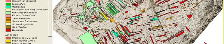
- To elaborate a conceptual and functional model for an information system for pre-cadastral material, making use of property maps, as an example of a historical GIS
- To obtain insight into the behaviour of historical researchers that use historical GIS, whereby the GIS for property maps serves as an example.
Study method
In order to be able to answer these questions, a GIS has been established for property maps. This GIS has been set up according to the calibration method: the GIS is comprised of phases, with a theoretical or practical study being set up in each phase, the results of which are placed in a new prototype for each phase.
To begin with, there was the idea of making the contents of map books accessible with the aid of a database system. It quickly became clear that a GIS would be more suitable for this. Then the parcels could be visually accessed, that is to say the user would see the parcels in their correct positions on a map. This adds a geographic search option. Another advantage of the use of a GIS was that now selections could be visualised. Thus patterns could be made visible, for example patterns in the distribution of the properties of a certain owner. In collaboration with such organizations as the Delft Municipal Archives, a project was started in order to expand the existing database by adding the data on all map books of the municipal archives, and linking this to a GIS.
In addition to the transfer of the database to the GIS, first the determination what type of GIS should be chosen. This depended on such factors as the modelling of the factor ‘time’.
The factor of time can be modelled in various ways. For the GIS that was developed in this study, we chose a branching time model and a multi-perspective time model. A branching model is based on the fact that each parcel is dated individually, independently of other parcels. A multi-perspective time model also applies, because there is a difference between validity time and input time. The models are concretised by including validity time as an attribute in the database. By working with map layers that have different validity times, a temporal cross-section is also created.
With regard to GIS’s with a historical application, a system can be a historical GIS (HGIS) or a temporal-historical GIS (THGIS). The present study involves an HGIS. This is determined by the nature of the sources of which the GIS is established: map books. The parcels on the maps in map books usually have only one validity time that is stored in the database. There is indeed supplementary data in the system, in the form of a series of topographic maps from various years, but the parcels are the object in this study and they have only a single validity time.
When we speak of the design of a GIS, to a great extent this comes down to the design of the database, because this determines the possible questions. For parcel information, originating from old maps, a historic database has to be designed.
The next step in the calibration study is to determine what it must be possible to do with a GIS for property maps.
In chapter 5, an overview of the possibilities that a GIS offers in the field of historic cartography and historic-geographic research is presented.
The GIS can be used very well as an access application for property maps. If the use of the GIS, however, is limited to accessing data, many application possibilities of the system are ignored.
The possibility of geo-referencing localisation sources and then placing them on top of each other makes GIS an excellent tool when it comes to localisation. Above all, GIS simplifies the localization of parcels in areas where the landscape has changed significandy.
One of the options related to accuracy that is possible with the GIS for parcels on large scale maps, such as property maps, is the overlay method. A condition for this is that the maps that are laid on top of each other must be geo-referenced.
In spatial analyses, statistical calculations are carried out that apply to geographic space. For historic applications, data can be obtained from censuses, the Cadastral Register, or from mortgage or rental records.
The fact that various geo-referenced map layers of the same scale can be combined makes GIS excellent for property maps when it comes to landscape reconstruction. Property maps can supply details for these reconstructions.
Three-dimensional presentation of a landscape can be useful. The image is less abstract than a two-dimensional map, the user can obtain an impression of the relief in the landscape, and often a three-dimensional model can be rotated, such that the object can be studied from all sides. The advantage of three-dimensional landscape modelling is reinforced with the addition of animations. This can make the development of a landscape clear, or can allow a fly-over of an area.
Many types of historic GIS projects are underway at present. The projects vary in terms of topic, from specific projects to clearinghouses and software. One can certainly not say that all of the projects discussed here provide information on a parcel level, such as is indeed the case with regard to the system involved in this study. Looking at the possible use of GIS in historical geography, we note that most of the projects we have discussed are suitable for use in socio- historic research. The systems can also be used for accessing data, reconstructing landscapes, carrying out spatial analyses, localization and archaeology.
The next phase in the calibration process is the study of how the users deal with the system. The study focuses on both the functional requirements of the system and the cognitive aspects of the user. It is above all the latter aspect that directs the choice of study method in terms of the think aloud method. This method is based on the principle of the real-time collection of thoughts that test persons voice during the execution of a task. These thoughts are video taped, with changes on the screen of the test persons also being recorded. The video tapes are analysed and made into verbal protocols.
Six test persons in the first test group are instructed to carry out a number of assignments. The assignments are spread across width tasks and depth tasks. The tasks within these assignments are hierarchically structured. The eight test persons from the second test group must come up with questions themselves that they wish to answer with the system. Supplementary information comes from intake and follow-up interviews.
The verbal protocols are analysed according to methodology followed by the test persons, the knowledge of data, the establishment of links both in terms of width and depth, the execution of source critique and temporal critique.
Results
The data model and the functional model of the end version of the GIS for property maps were established on the basis of the results of the user’s study. Appendix 11.13 shows these models.
From the verbal reports, we see that the more complicated an assignment, the more different types of data the test persons require. Despite the great difference in the use of data, one cannot say that the answers to the questions that are asked always differ from one another. This shows that test persons are quite able to find answers in a creative manner, using the data most suitable for them. It has not been demonstrated that people take longer to carry out more complicated tasks and that they also make more errors. This clearly shows that a learning curve occurs.
There is indeed a difference between width and depth assignments. The test persons had considerably more trouble with the depth assignments.
Test persons who had to come up with their own projects generally chose assignments that fell into level 1 in the category of width assignment. It may be expected that users think of more difficult questions when they have more experience with the system.
Conclusions
This study has shown what steps must be taken in order to establish a historical GIS according to the calibration method. Within this method we used various study techniques.
It can be established through a literature study what types of GIS can be differentiated for historic research, what spatial-temporal models exist, what role a GIS can play in various types of study, and what historic GIS applications have already been initiated.
In addition to literature study, interviews were also used in order to obtain insight into the wishes and expectations of the users. Finally, a user study was undertaken in which the think aloud method was used in order to study the usage strategies of users. This, incidentally, was preceded by a theoretical examination of the possibilities for a user study. This theoretical examination does not belong to the calibration process, but it was vital when it came to setting up a user study.
This combination of different techniques makes it possible to consider all aspects (theory, user wishes, actual use) in the study. The calibration method turns out to function well when it comes to making the possibilities and problems of a historical GIS clear.