Muller’s Maps of the Continents
An exhibition on the occasion of the 28th International Conference on the History of Cartography, Amsterdam, in the reading room of the Allard Pierson and the collections of the University of Amsterdam, 14 July 2019.
The Muller collection consists of 8705 maps originating from the antiquarian map- and book-seller Frederik Muller (1817-1881). This collection was acquired in 1910 from Muller’s heirs by the Royal Dutch Geographical Society (KNAG) and is since then on loan to the library of the University of Amsterdam – Allard Pierson | The Collections of the University of Amsterdam, like thousands of other maps that are formally the property of the KNAG .
The collection consists mainly of maps from Dutch atlases from the 16th to the 18th centuries; sometimes several copies are held of the same map from different atlases. It also includes a small number of charts, atlas maps by foreign publishers and some exceptional pieces, like 19th-century wall maps.
The importance of the collection however is established by the Dutch atlas maps. Since they are stored in geographical order, it is easy to compare maps of the same region and find out if maps are different states of the same copperplate, copies of each other, based on new mapping etc. Moreover, the different style of colouring can be seen quite easily.
Although not all yet available online, a large number of the ‘Muller maps’ are scanned: a selection of 1,000 is available at Wikimedia Commons.
In this small exhibition we made a selection of continental maps. Each continent is represented by 10 to 12 maps selected on the basis of decorations (like cartouches), colouring styles, states and copies. And a few exceptional maps are shown.
Scroll through the different selections of maps from the Muller collection. Click on the maps for a large size scan.
Europe
The Muller collection includes 72 maps of Europe.
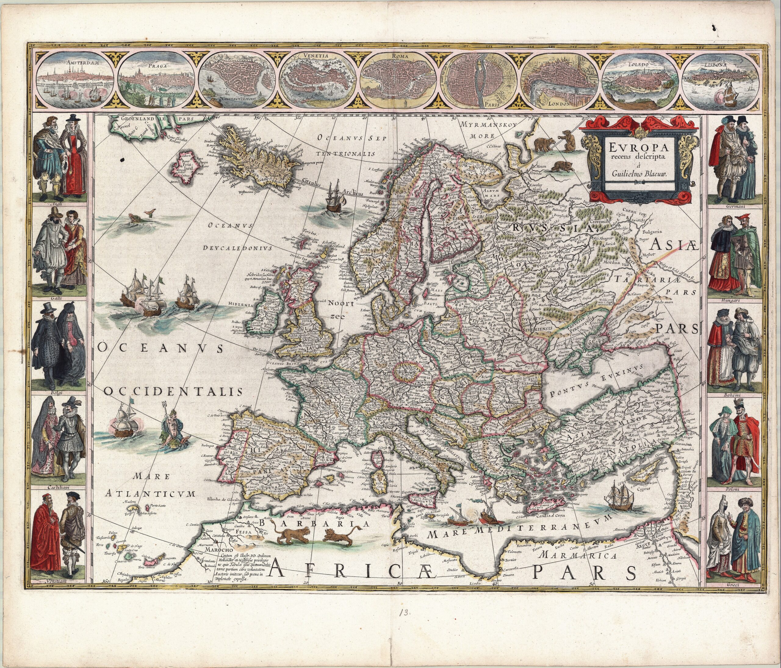
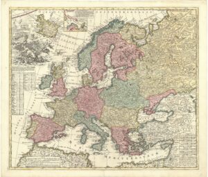
 (1) Evropa recens descripta (New map of Europe). Amsterdam: Willem Jansz. Blaeu, 1630 (first state 1617). 41.5 x 55.5 cm (OTM: HB-KZL 31.04.36)

Map with decorative borders: to the left and right ten pairs of costume figures and at the top plans and views of nine important cities, starting with Amsterdam. The map dates from 1617, but was used in atlases from 1630 (Schilder 2000, map 26; KAN 1000:2.1)
 (2) Europa delineata et recens edita per Nicolaum Visscher (Europe drawn and recently published by Nicolaes Visscher). Amsterdam: Nicolaes Visscher II, c. 1681 (first state c. 1660). 43 x 54 cm (OTM: HB-KZL 31.03.70)
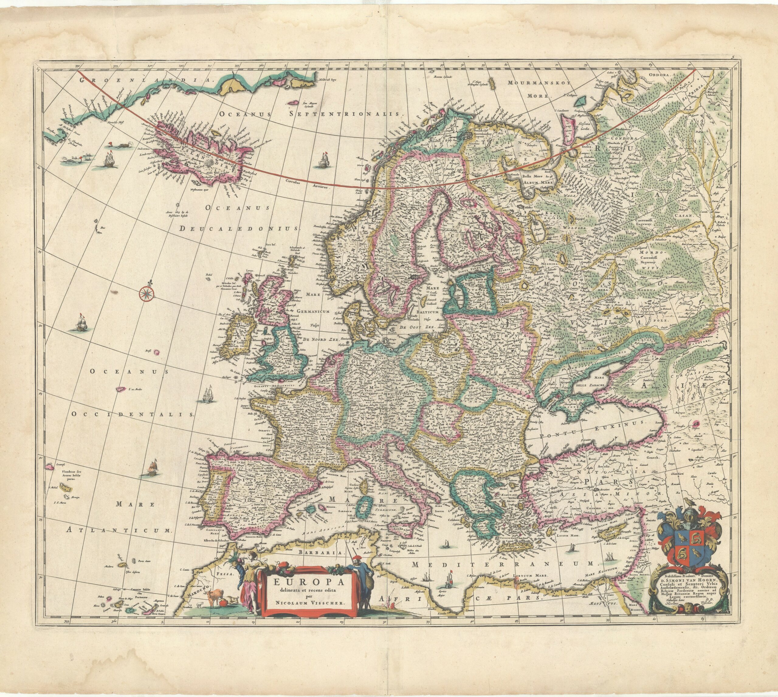
With border colouring, dedicated to the Amsterdam burgomaster Simon van Hoorn, who was ambassador to king Charles II of England in 1660, as referred to in the dedication. His coat-of-arms has the wrong colours, indicating that the map was coloured later (see no. 3). (KAN 1000:51.3)
 (3) Europa delineata et recens edita per Nicolaum Visscher (Europe drawn and recently published by Nicolaes Visscher). Amsterdam: Nicolaes Visscher II, c. 1685 (first state c. 1660). 43 x 54 cm (OTM: HB-KZL 31.04.01)

Later state of no. 2, with a reference to the 1682 privilege added. The regions are fully coloured. The coat-of-arms of Simon van Hoorn is in the correct colours. (KAN1000:51.4)
 (4) Nova et accurata totius Europae descriptio (New and accurate map of whole Europe). Amsterdam: Frederick de Wit, c. 1682 (first state c. 1672). Engraved by Abraham Deur. 49 x 58 cm (OTM: HB-KZL 31.04.10)
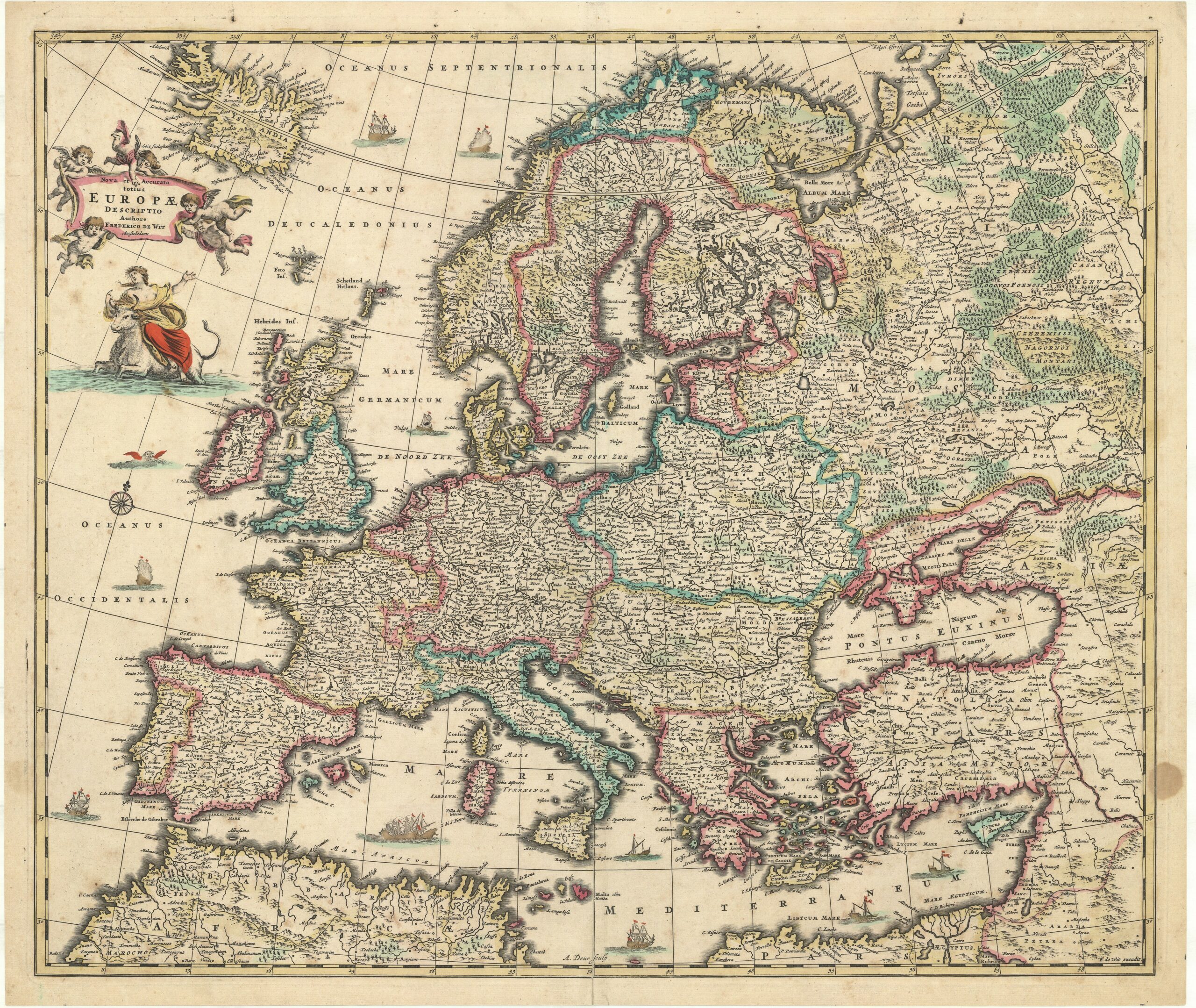
With coloured borders. The only decorative element is the depiction of the abduction, by Zeus in the shape of a bull, of the Cretan princess Europa. (Carhart 2016, map 19; KAN 1000:52B.3)
 (5) Nova et accurata totius Europæ descriptio (New and accurate map of whole Europe). Amsterdam: Justus Danckerts, c. 1700 (first state c. 1683/84). 49 x 58 cm (OTM: HB-KZL 31.04.04)
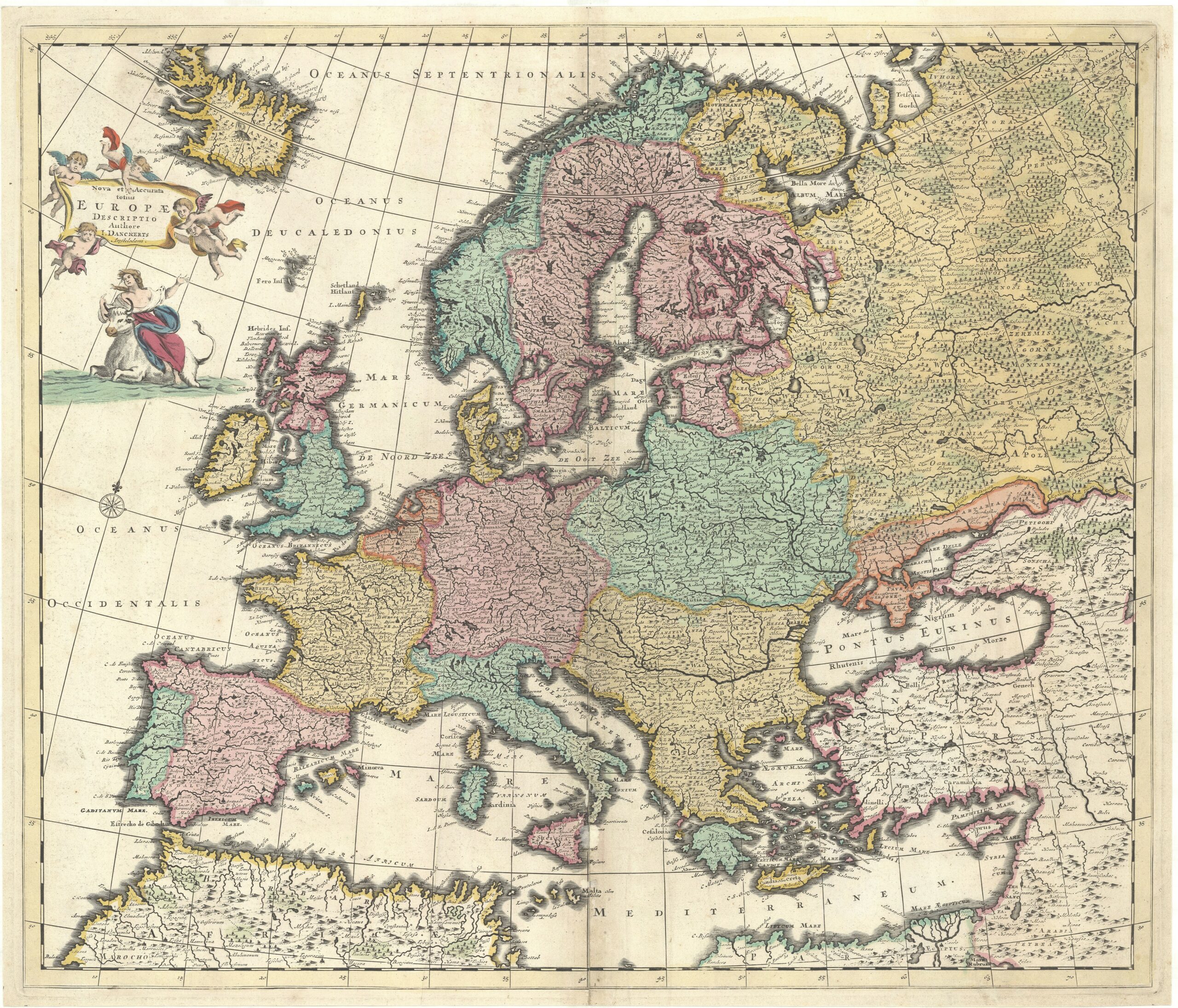
Justus Danckerts made two atlas maps of Europe, both copied after those of Frederick De Wit (no. 4). This first map follows the first state of De Wit’s of c. 1672. On this copy the kingdoms of Europe are fully coloured. (KAN 1000:533A.3)
 (6) Accuratissima Europæ tabula multis locis correcta, et nupperrime edita (Very accurate map of Europe, corrected in many places and newly published). Amsterdam: Justus Danckerts, c. 1699-1701. 49 x 58 cm (OTM: HB-KZL 31.04.03)
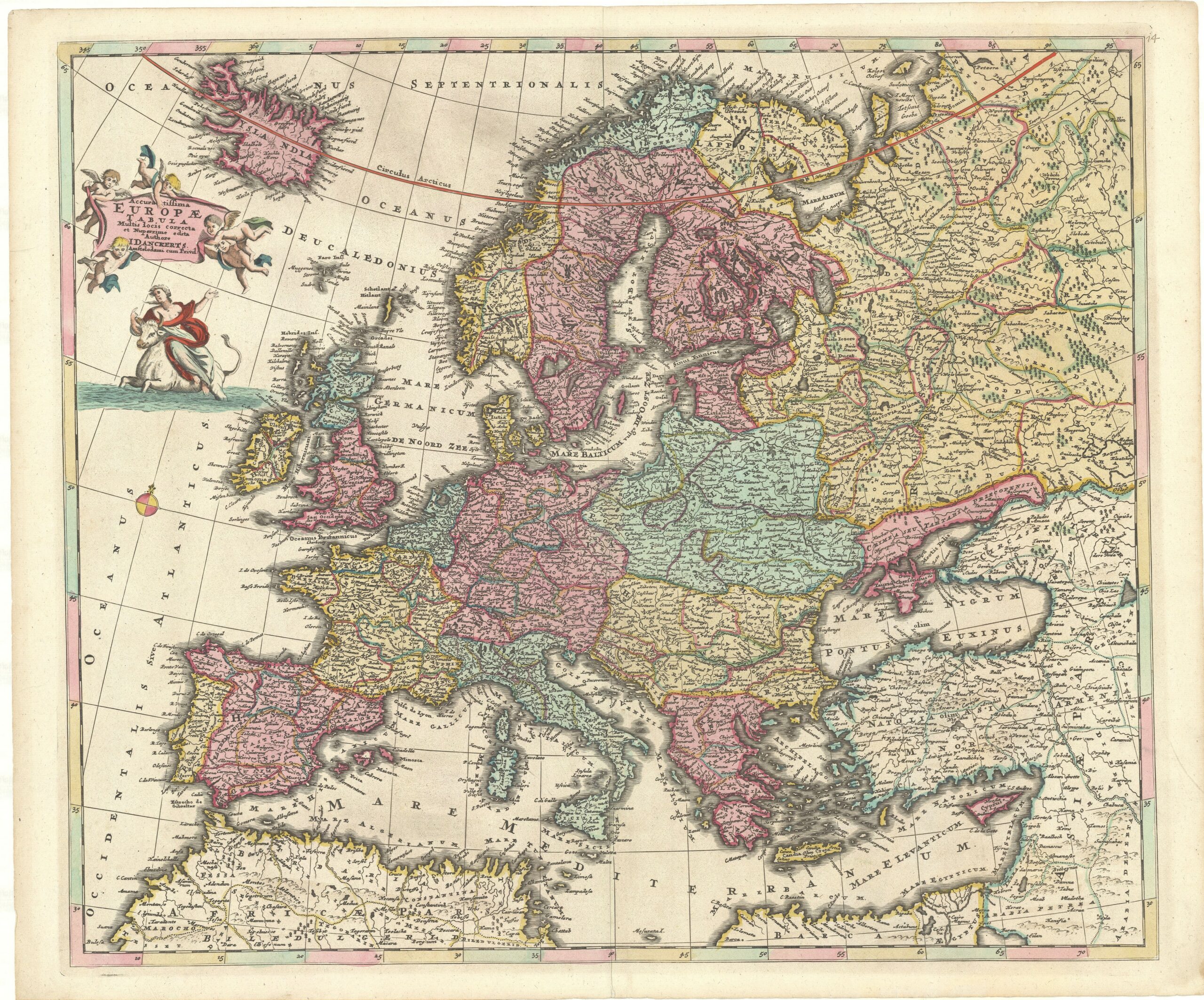
The second map of Europe by Justus Danckerts, published about twenty year after the first. For this, Danckerts copied the sixth state of De Wit’s map of c. 1691-93 (no. 4). The main difference is the addition of borders for the subregions. Just like on map no. 5 the regions are fully coloured, but the subregions have border colouring only. (KAN 1000:533B.1)
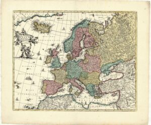 (7) Nova et accuratè divisa in regna et regiones præcipuas Europæ descriptio (New map of Europe, accurately divided in kingdoms and important regions). Amsterdam: Covens & Mortier, c. 1730 (first state by Gerrit van Schagen, c. 1680-90). 43.5 x 54 cm (OTM: HB-KZL 31.03.66)
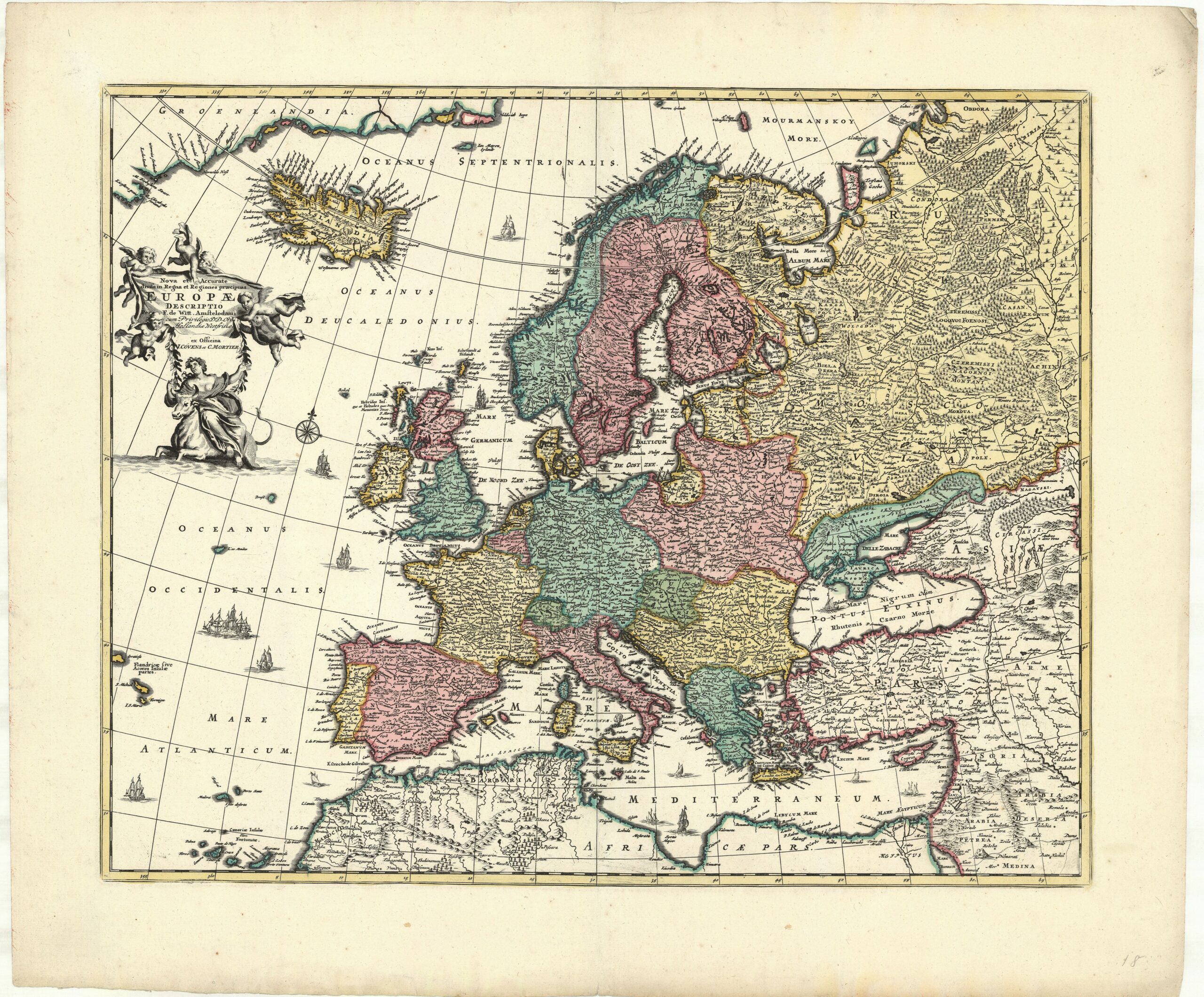
A pseudo-De Wit map. It is the second state of Nova et accurata totius Europae descriptio by Gerrit van Schagen. The original De Wit copperplate (no. 4) was severely damaged, so Covens & Mortier decided to change title and imprint of Van Schagen’s map, which was a copy of De Wit’s. (KAN 1000:582.2)
 (8) Europa Excultissima (The most cultivated Europe). Amsterdam: Petrus Schenk I, c. 1710 (first state c. 1700). 49 x 57 cm (OTM: HB-KZL 31.04.06)
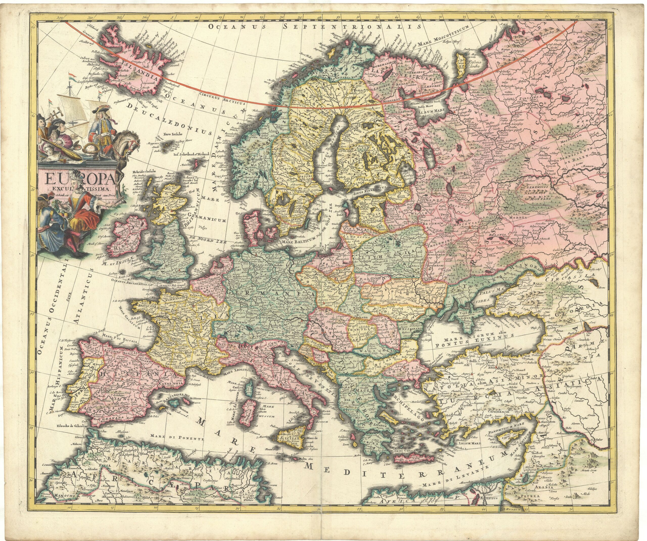
Petrus Schenk the Elder published three different maps of Europe for his atlases. In this selection are two: the first, dating from c. 1700, shows a fine etched cartouche symbolising ‘The most cultivated Europe’ through instruments of arts and science, a richly clothed man on a horse and a woman with fruit, with a Dutch trading vessel in the background. (KAN 1000:551A.2)
 (9) Eclipseos Solis Totalis … d. 12 Maji 1706… in Europa… Repræsentatio (Depiction of the total solar eclipse over Europe of 12 May 1706). Amsterdam: Petrus Schenk I, 1715 (first state 1706). 49 x 58.5 cm (OTM: HB-KZL 31.04.21)

On 12 May 1706 a total solar eclipse was seen in most of Europe. For this occasion Schenk published a map of Europe that indicated where the eclipse could be seen. Also he included an illustration with an explanation of a solar eclipse. It was made by the Dutch mathematician Simon van der Moolen after information of Johann Gabriel Doppelmayr. Another eclipse followed on 3 May 1715, for which Schenk’s son Peter Jr. adapted his father’s 1706 map with a new illustration. (KAN 1000:551B.2)
 (10) Europæ in tabula Geographica delineatio (Depiction of Europe in a geographical map). Amsterdam: Petrus Schenk Jr., c. 1730. 50.5 x 58.5 cm (OTM: HB-KZL 31.04.33)

A complete new map of Europe was made by Petrus Schenk Jr. c. 1730 making use of information supplied by the Saxonian geographer Adam Friedrich Zürner. Since Schenk had a shop in Leipzig in Saxony and published more of Zürner’s maps, he obviously knew him personally and got first-hand information from him. Note also the finely-etched scene of Europe’s abduction by the bull-like Zeus; the title of the map on a flag carried by Mercurius, god of trade; and the little scene of shooting a polar bear (KAN 1000:551D)
 (11) L’Europe divisé suivant l’etendue de ses principaux Etats subdivisés en leurs principales provinces par les Srs. Sanson… revue et changée… par le sr. Robert. Amsterdam: Hendrik de Leth, 1741. 45.5 x 54.5 cm (OTM: HB-KZL 34.12.16).
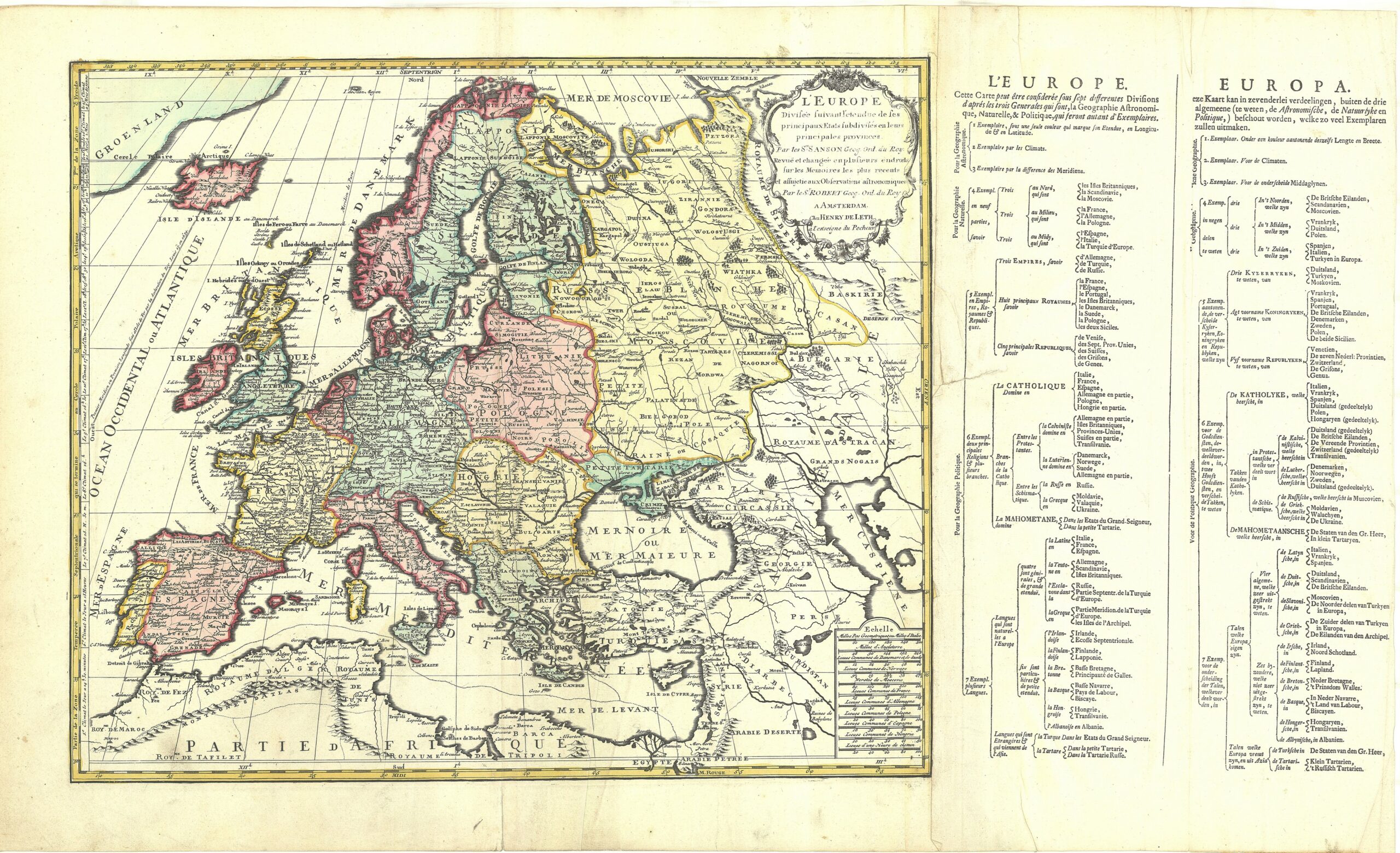
The map is copied after one by Gilles Robert de Vaugondy, who used the information of his predecessor Nicolas Sanson and Nicolas’s son Guillaume. French cartography led in the late 17th and 18th centuries. According to the letterpress text at the side, the map could be coloured in seven different ways: three astronomical ways (geographical co-ordinates, climates, and prime meridians), one geographical, and three political (countries, religions, and languages). The present copy is coloured according to the countries.
Asia
The Muller collection includes 67 maps of Asia.
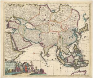
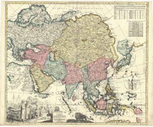
 (12) Asiæ nova descriptio (New map of Asia). Amsterdam: Frederick de Wit, c. 1670 (first state 1660). 44 x 56 cm (OTM: HB-KZL 33.12.45)

Among the earliest maps made by Frederick de Wit is a set of the continents with decorative borders in the style of Blaeu: costume figures on the sides and town plans and views at the top. (Carhart 2016, map 9; Schilder 2000, map 24; KAN 8000:52A.4)
 (13) Accuratissima totius Asiæ tabula recens emendata (Most accurate map of Asia, recently emended). Amsterdam: Frederick de Wit, c. 1680 (first state c. 1672). 48 x 57 cm (OTM: HB-KZL 33.12.04)

A dozen years after his first set of continent maps Frederick de Wit published a new set in a much more modern style. Instead of the decorative borders there is an Asian scene: a European merchant lazily sits on a bale of goods and offers, to a standing Persian or Arabian trader, a beaded necklace for the bales that the trader’s assistants are bringing. Several Asian animals are shown too. (Carhart 2016, map 10; KAN 8000:52B.3)
 (14) Exactissima Asiæ delineatio (Most exact map of Asia). Amsterdam: Theodorus Danckerts, c. 1706 (first state by Justus Danckerts, c. 1700). 49.5 x 58.5 cm (OTM: HB-KZL 33.11.71)

Justus Danckerts’ ‘Most exact map of Asia’ is a ‘most exact’ copy of De Wit’s second map of Asia (no. 13): even the scene with the merchant and trader is exactly copied. There are only some minor differences in toponyms and Danckerts omitted the ships in the oceans. (KAN 8000:533B.2)
 (15) Exactissima Asiæ delineatio in præcipuas regiones cæterasque partes divisa (Most exact map of Asia divided in its principal regions and other parts). Amsterdam: Carel Allard, c. 1705 (first state 1696). 51 x 60 cm (OTM: HB-KZL 33.11.68)

The Asian scene on this map is striking because it doesn’t show Asians offering their products to Europe as could be expected in this time. The seated figure in the bottom left corner wears a turban with pearls and a (peacock) feather, and holds a sceptre topped by a crescent moon. It is likely that he represents the sultan of the Moghul Empire. The scene is etched by Willem van der Gouwen after a drawing by Philip Tideman. (KAN 8000:542.3)
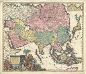
 (16) Asia quà nulla beatior ora; Tractus in Eöos vergens Mundique teporem (Asia, the richest area that exists, that extends to the east and (to) the tepid heat of the world). Amsterdam: Gerard & Leonard Valk, 1709. 49 x 59 cm (OTM: HB-KZL 33.12.10)
Valk’s map of Asia with an uncommon title includes the latest information, as the depiction of eastern Siberia follows Nicolaes Witsen with the long peninsula Yscaap and Yedso (Hokkaido) attached to the mainland. The latest discovery depicted is that of New Britain by William Dampier (1700) with the English toponyms Dampier Streights and Burning Hill. Dampier’s account was published in 1703. The title scene is an exact copy of that by Tideman on Carel Allard’s map (no. 15). (Translation of the Latin title by Theo Bressers) (KAN 8000:555B)
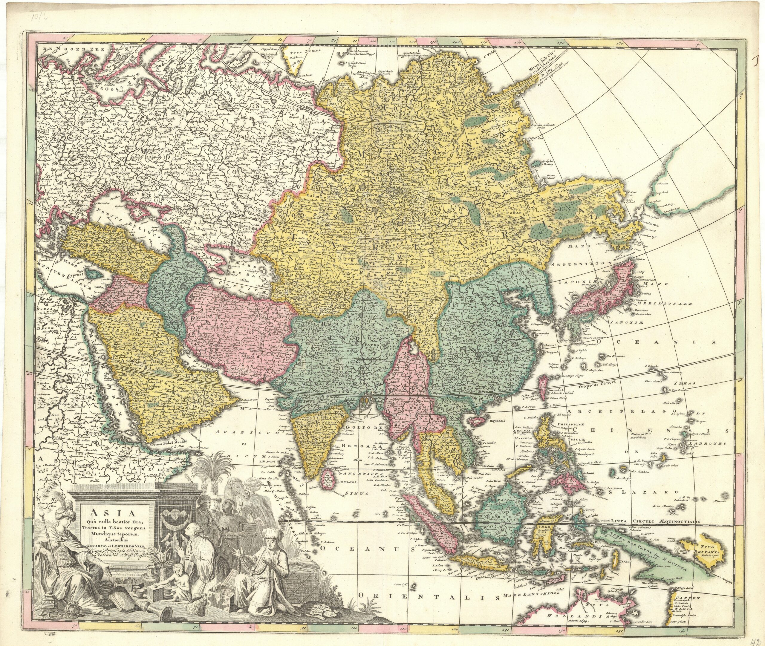
 (17) Asia exquisitissima (The most sought-after Asia). Amsterdam: Petrus Schenk I, c. 1703. 48 x 57 cm (OTM: HB-KZL 33.12.03)
Around 1703 Petrus Schenk the Elder made a four-map set of continents with elaborately-etched cartouches of ethnographical scenes and flora and fauna from their inhabitants. He gave the maps unusual titles consisting of the name of the continent with a characteristic in superlative: Europe is most cultivated (excultissima), Asia most sought-after (exquisitissima), Africa most elaborate (elaboratissima) and America simply most new (novissima) and most accurate (accuratissima) (see nos. 8, 29, and 36). (KAN 8000:551A.1)
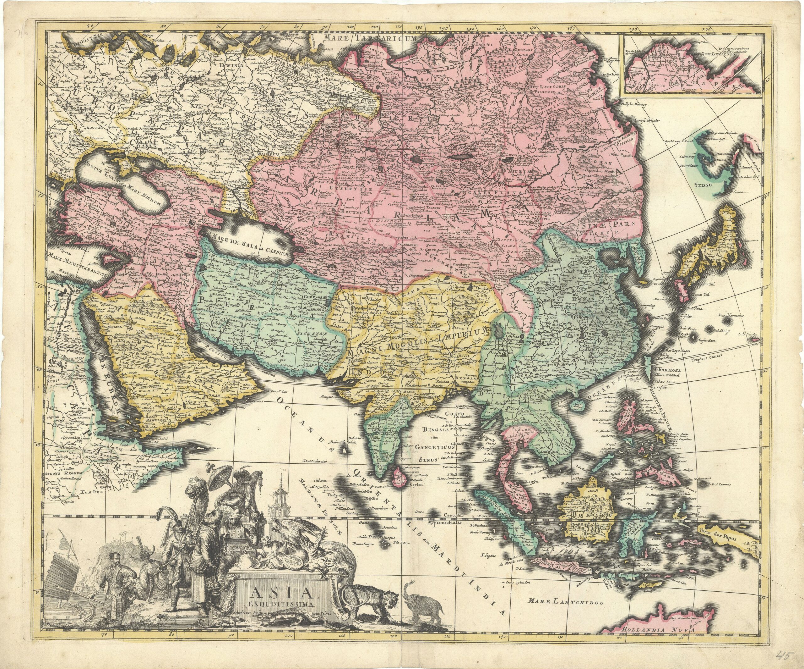
 (18) Asia accuratissime descripta (Asia very accurately described). Amsterdam: Petrus Schenk II, c. 1714 (first state c. 1703). 48 x 57 cm (OTM: HB-KZL 33.11.67)

The map of Asia, described with no. 17, is the only one of the continents maps on which Petrus Schenk changed the title to a more usual form. Later some sea names were added. Note that the complete cartouche is re-etched, see the elephant’s trunk. The regions indicated by colour are not completely the same on both maps. (KAN 8000:551A.4)
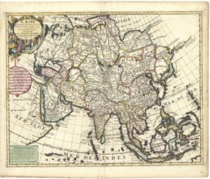 (19) L’Asie dressée sur les Observations de l’ Academie Royale des Sciences et quelques autres et sur les memoires les plus recens par G. de l’Isle Geographe. Amsterdam: Petrus Schenk I, 1708. 45 x 57 cm (OTM: HB-KZL 33.12.20)
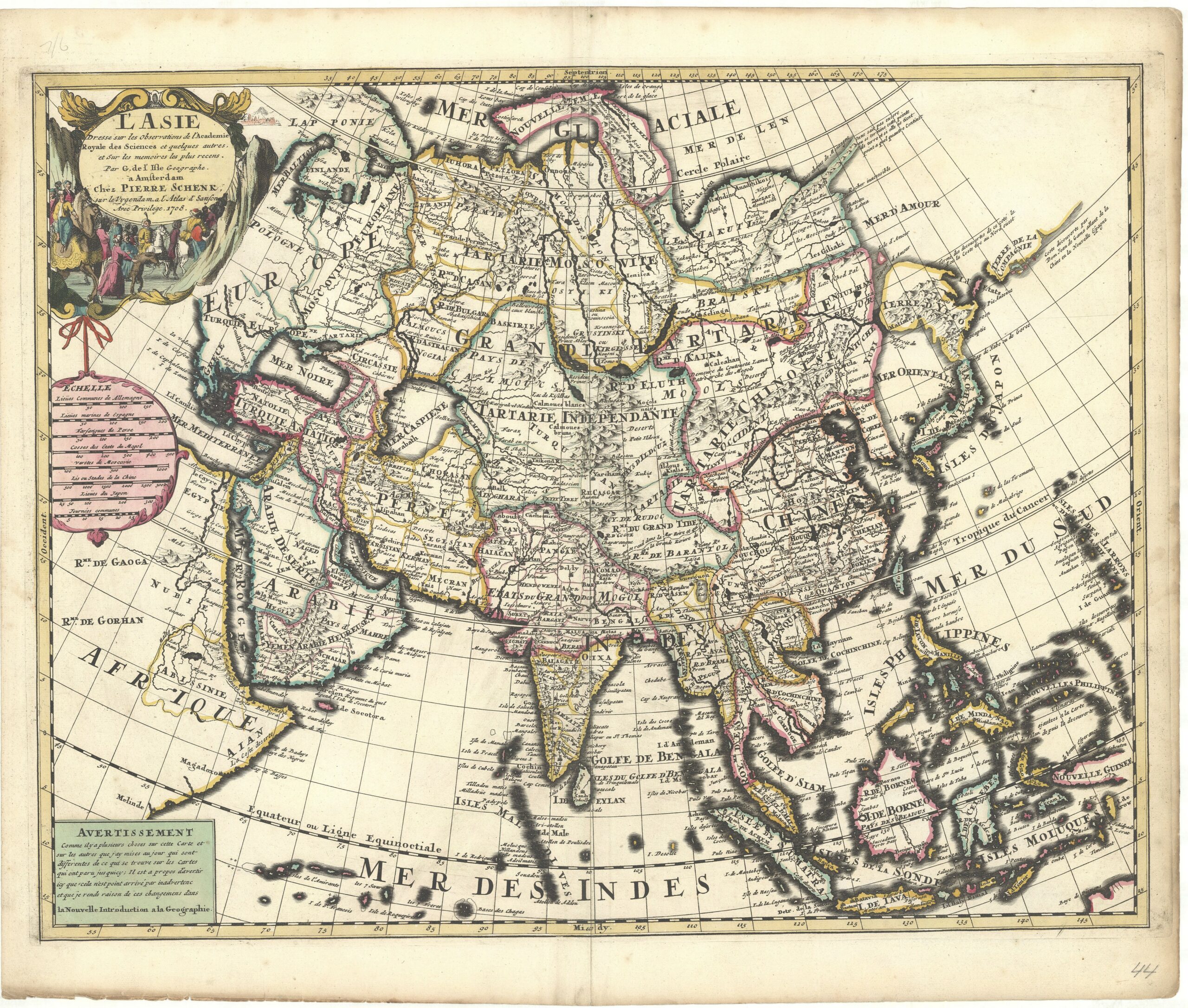
Guillaume Delisle (de l’Isle) was one of the most renowned mapmakers in Paris in the early eighteenth century. Many of his maps were copied in Amsterdam by the firms of Pieter Mortier and Petrus Schenk. Delisle’s map of Asia of 1700, with a cartouche engraved and designed by Nicolas Guérard, is – with the cartouche – faithfully copied by Schenk, but omits Guérard’s name. (KAN 8000:551B.1)
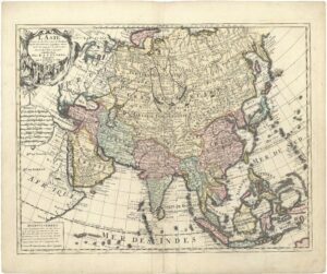 (20) L’Asie dressée sur les Observations de l’ Academie Royale des Sciences et quelques autres et sur les memoires les plus recens par G. de l’Isle Geographe. Amsterdam: Reinier & Josua Ottens, c. 1735 (first state by Petrus Schenk I, 1708). 45 x 57 cm (OTM: HB-KZL 33.12.21)
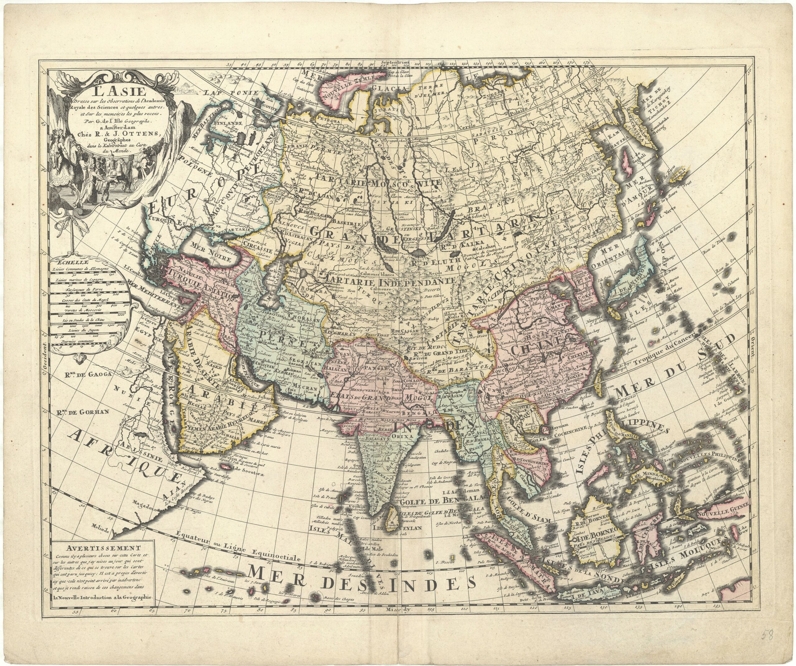
The brothers Reinier & Josua Ottens acquired several copperplates from the Schenk firm and republished them in the 1730s. Instead of that of Schenk, their name was engraved on the maps which were often updated. On this map the north and north-east coasts of Asia and the Caspian Sea are updated and St. Petersburg and several islands in the Pacific were added. (KAN 8000:551B.2)
 (21) Asiæ in tabula Geographica delineatio (Depiction of Asia in a geographical map). Amsterdam: Petrus Schenk Jr., c. 1730. 50.5 x 58.5 cm (OTM: HB-KZL 33.11.64)

Around 1730 Petrus Schenk Jr. published a set of world and continent maps drawn by the Saxonian geographer Adam Friedrich Zürner. The top corner of the Asia map includes a table listing the geographical location of importan towns. The position of the Chinese harbour town of Canton is given as 133°23’15” East of Ferro and 23°7’46” N: the latitude is correct (23°7’44” N according to LatLon.net), and the longitude is nearly so at c. 131° East of Ferro – a difference of only 234 km/145 miles (the meridian of Ferro considered to be 20 degrees west of Paris, as was the use in the 18th century). (KAN 8000:551C)
 (22) Nouvelle carte illustrée de l’Asie indiquant les grandes divisions physiques, la distribution géographique des végétaux et des minéraux, les ports de commerce, villes industrielles et places fortes des différents états. By Alexandre Vuillemin; engraved by Langevin. Paris: Charles Fatout, 1855. 58.5 x 82.5 cm (OTM: HB-KZL 34.28.03)
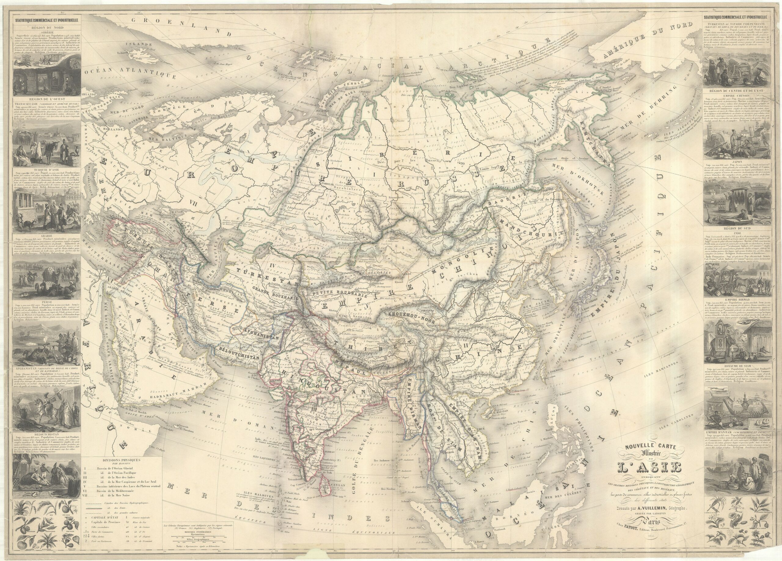
Engraved on steel, this 1855 French map of Asia is one of the curiosities in the Muller collection. It has decorative borders on both sides with ethnographical scenes from the different Asian regions with information as surface area, population, size of the army (!), ores, handicraft products and religion. Peculiar is that the Indonesian archipelago is not part of Asia, but of Oceania.
Africa
The Muller collection includes 56 maps of Africa.
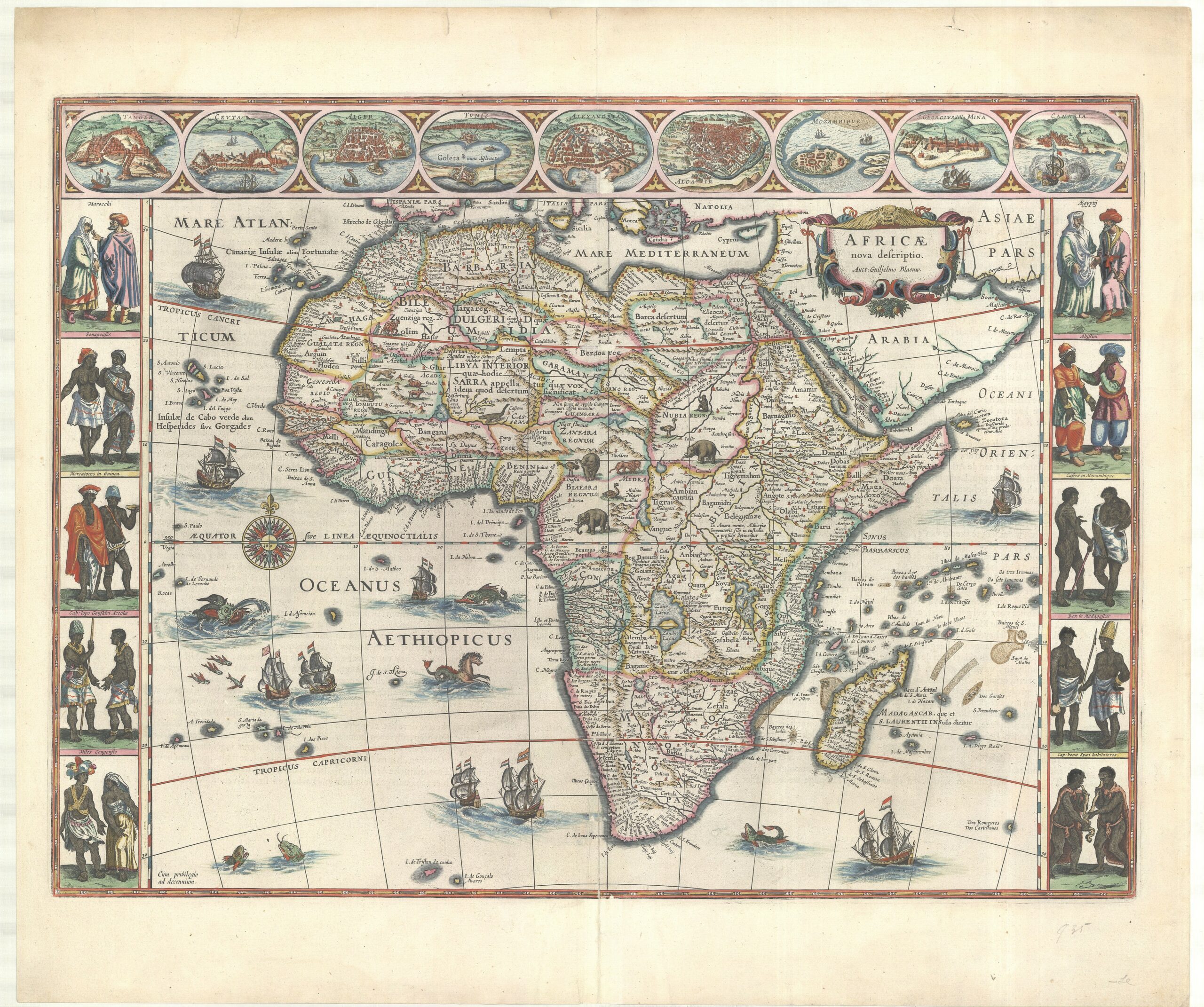
 (23) Africæ nova descr. (New map of Africa). Amsterdam: Claes Jansz. Visscher, 1652 (first state by Pieter van den Keere, 1614) (OTM: HB-KZL 33.17.46)
Until the late nineteenth century the interior of Africa was unknown to Europeans, although this cannot be seen on most of the early maps, like this one by Van den Keere. Africa’s interior is filled with rivers, mountain ranges and towns as if it was completely known – all based on Ptolemy, Arabian and Portuguese sources and myths. Note at the east coast of the Zaïre lacus: ‘hic Amazones habitare dicuntur’ – it is said that Amazons live here. The cartouche with the woman riding a crocodile was added by Visscher (Betz 2007, map 55; Schilder 2000, map 10; KAN 8600:364)
 (24) Africæ nova descriptio (New map of Africa). Amsterdam: Willem Jansz. Blaeu, 1630 (first state 1617). 41 x 55.5 cm (OTM: HB-KZL 33.18.13)
Willem Jansz. Blaeu published in 1617 a set of maps of the continents with decorative borders. The cartography is mostly based on his 1608 wall maps, which, in turn, followed the 1605 wall map of the world (Betz 2007, map 57; Schilder 2000, map 11; KAN 8600:2)
 (25) Africæ accurata tabula (Accurate map of Africa). Amsterdam: Nicolaes Visscher I, 1682 (first state c. 1660). 43.5 x 54.5 cm (OTM: HB-KZL 33.17.43)
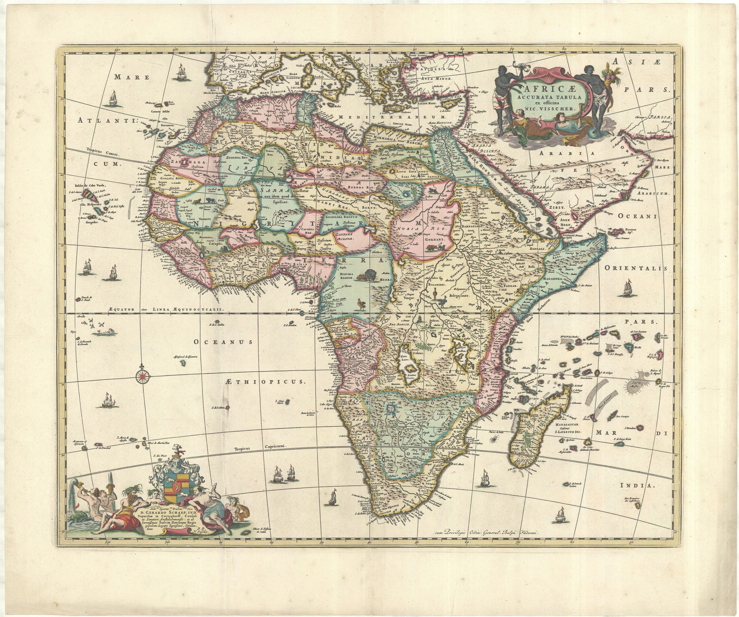
The major part of the map is, just as those preceding, based on old sources. Visscher however replaced a number of Portuguese names in South Africa by Dutch names as Tafel bay, Tafel berg, Robben Eyl. and Schorre hoeck, referring to the first Dutch settlement under Jan van Riebeeck in 1652. (Betz 2007, map 87; KAN 8600:51.2)
 (26) Nova Africa descriptio (New map of Africa). Amsterdam: Frederick de Wit, c. 1665 (first state 1660). 44 x 56 cm (OTM: HB-KZL 33.17.44)
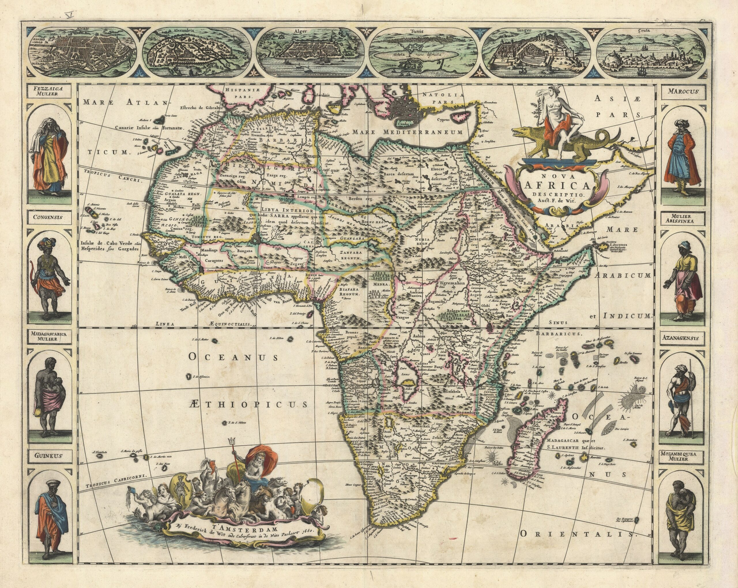
Since no new data are available for Africa, De Wit’s ‘new’ map of Africa is based on the models by Blaeu of 1617 (no. 24), while he copied the woman on the crocodile on the title cartouche from Visscher’s edition of Van den Keere’s map (see no. 23). The largest cartouche, carrying the imprint and a marine scene with Neptune and a shield with an African warrior, is remarkable. (Carhart 2016, map 7; Betz 2007, map 96; KAN 8600:52A.2)
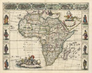
 (27) Totius Africæ accuratissima tabula (Very exact map of whole Africa). Amsterdam: Frederick de Wit, c. 1682 (first state c. 1672). 49 x 58 cm (OTM: HB-KZL 33.17.47)

Twelve years after his first Africa map (no. 26) De Wit published his second, for which he clearly used also a source other than the old Blaeu map. The coastal regions, especially, show more details, as rivers and their names. Interior Africa is mainly unaltered, only the shape of the lakes and mountains is slightly different. Characteristic is the odd spelling of the Cape of Good Hope region: Cabo de bona Zperanza. The title cartouche shows inhabitants of North and Central Africa and their products. (Carhart 2016, map 8; Betz 2007, map 114; 8600:52B.4)
 (28) Novissima et perfectissima Africæ descriptio per Fredericum de Witt (Very new and very perfect map of Africa by Frederick de Wit). Amsterdam: Reinier & Josua Ottens, c. 1740-50 (first state by Justus Danckerts, c. 1700). 49.5 x 58 cm (OTM: HB-KZL 33.17.49)
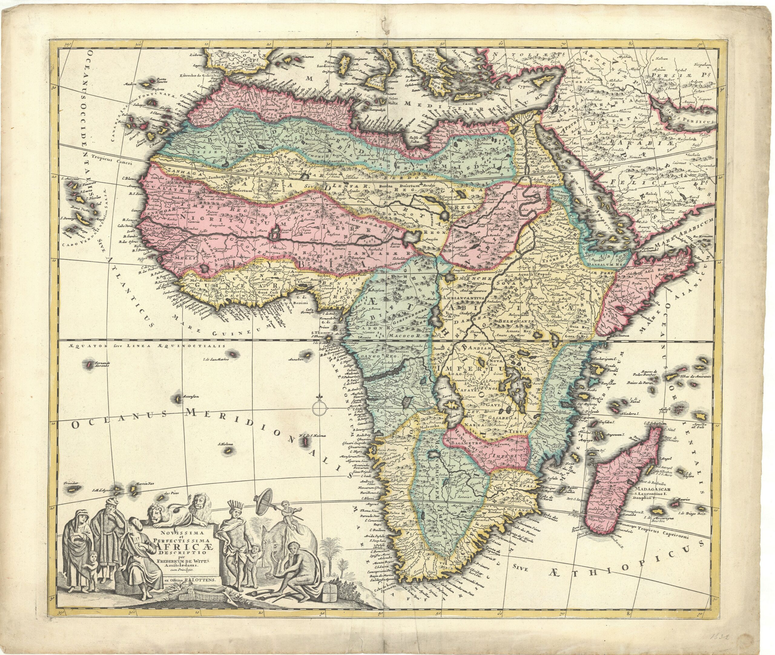
After De Wit’s death most of his copperplates came in possession of Pieter Mortier, and Covens & Mortier, who republished most of them. Their major competitor firm of the Reinier & Josua Ottens brothers had the copperplates of the less known map publishers Gerrit van Schagen and Justus Danckerts, and republished them adding De Wit’s name. This map of Africa was first published by Justus Danckerts. Since Danckerts had copied De Wit’s map (no. 27), the attribution to De Wit is not completely untrue. (Betz 2007, map 168; KAN 8600:533B.2)
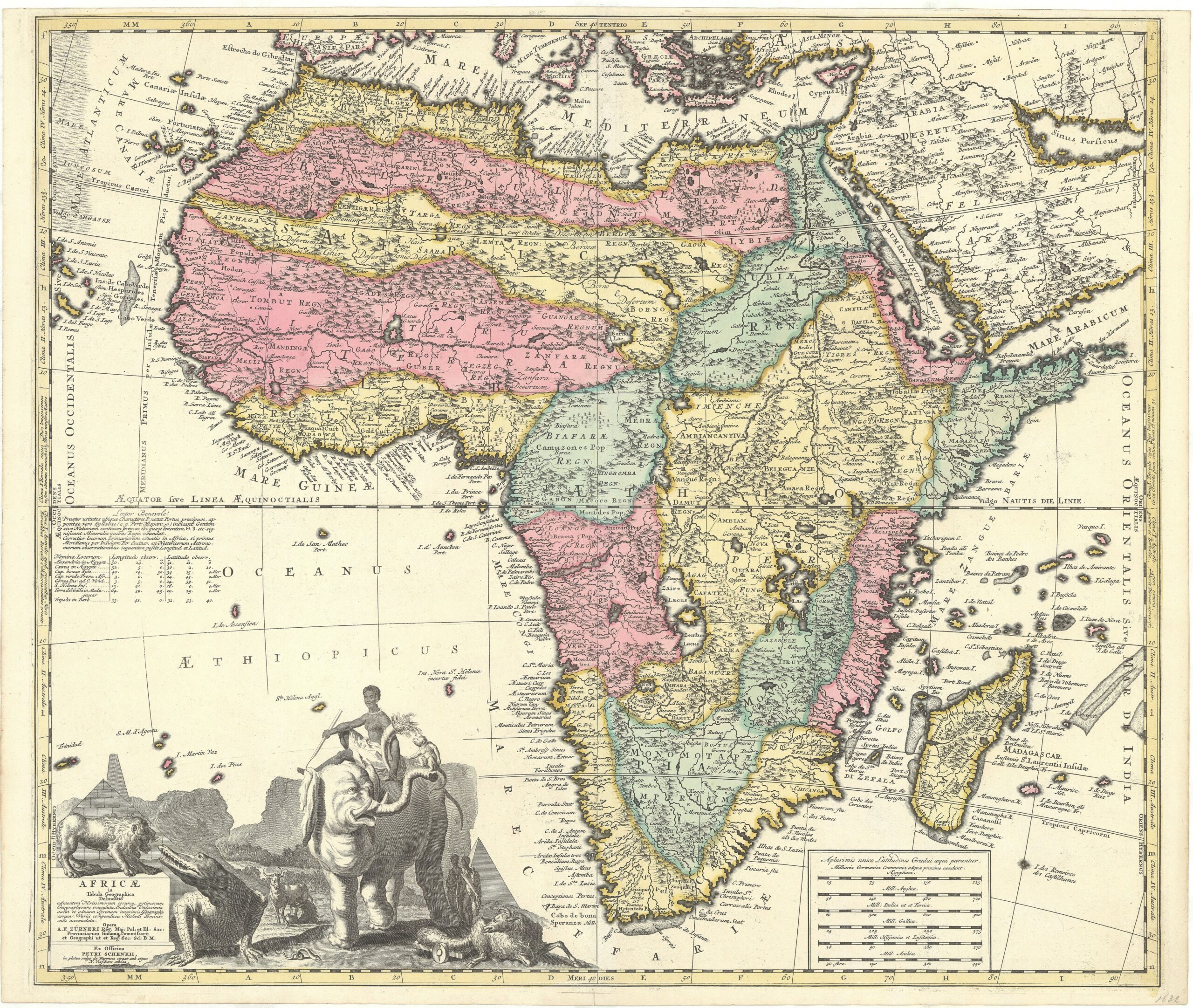
 (29) Africa elaboratissima (The most elaborate Africa). Amsterdam: Petrus Schenk I, c. 1703. 47 x 55 cm (OTM: HB-KZL 33.17.69)

This map of Africa belongs to Petrus Schenk’s set of continents maps with elaborately-etched cartouches of ethnographical scenes and flora and fauna from the inhabitants. The map is also a copy of that of De Wit (no. 27). The scene shows an African trader on an elephant with, in the background, the Table Mountain (KAN 8600:551A)
 (30) Africæ in tabula Geographica delineatio (Depiction of Africa in a geographical map). Amsterdam: Petrus Schenk Jr., c. 1730. 50.5 x 59 cm (OTM: HB-KZL 33.17.70)
Zürner’s map of Africa is, according to the extended title, based on the very latest and best geographers; but since there were not many new discoveries in Africa, more or less the same image is shown as that of De Wit (no. 27), but with the corrected name of the Cape of Good Hope. Zürner added several new names, and to the Dutch presence in South Africa he refers with the word ‘Holl.’. (KAN 8600:551C)
 (31) L’Afrique diuisée en ses empires, royaumes, et estats. Amsterdam: Jan Barent Elwe, 1792 (first state by Pieter Mortier, 1694). 45 x 57.5 cm (OTM: HB-KZL 33.17.61)
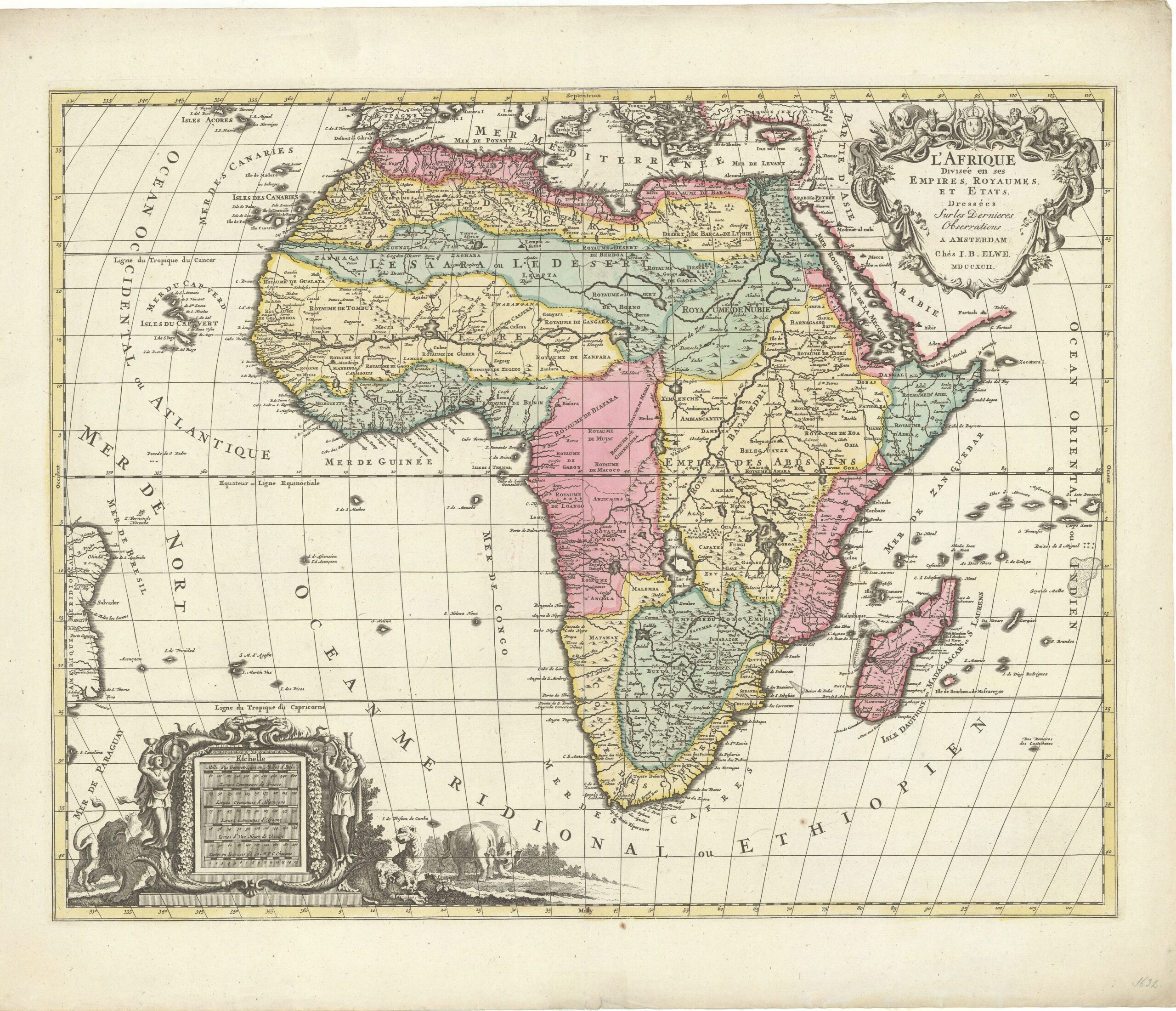
The publisher Jan Barent Elwe bought many old, but still useable, copperplates and made an atlas with those in 1792. He added his name and the date 1792, but altered nothing else. For Africa he used the 98 years-old copperplate by Pieter Mortier, copied after a map published by Hubert Jaillot in 1674: this, in turn, copied from the 1668 map by Guillaume Sanson. The information on Elwe’s map of Africa of 1792 therefore was at least 124 years old. (Betz 2007, map 158; KAN 8600:563A.4)
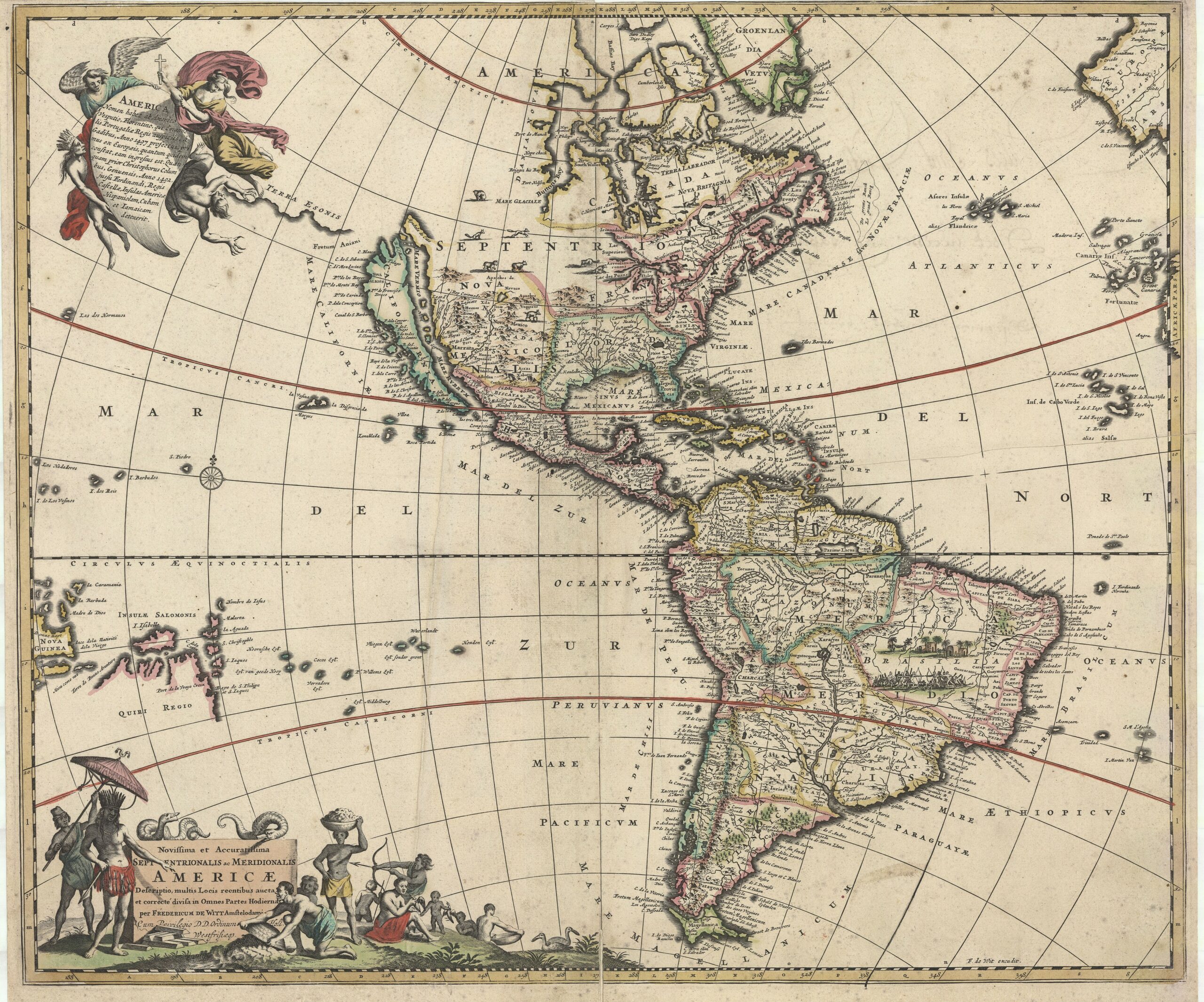
America
The Muller collection includes only 12 maps of America, a further 12 of North America and 17 of South America.
 (32) Novissima et accuratissima totius Americæ descriptio (Very new and accurate map of whole America). Amsterdam: Nicolaes Visscher II, 1682 (first state by Nicolaes Visscher I, c. 1660). 43.5 x 54 cm (OTM: HB-KZL 33.22.40)
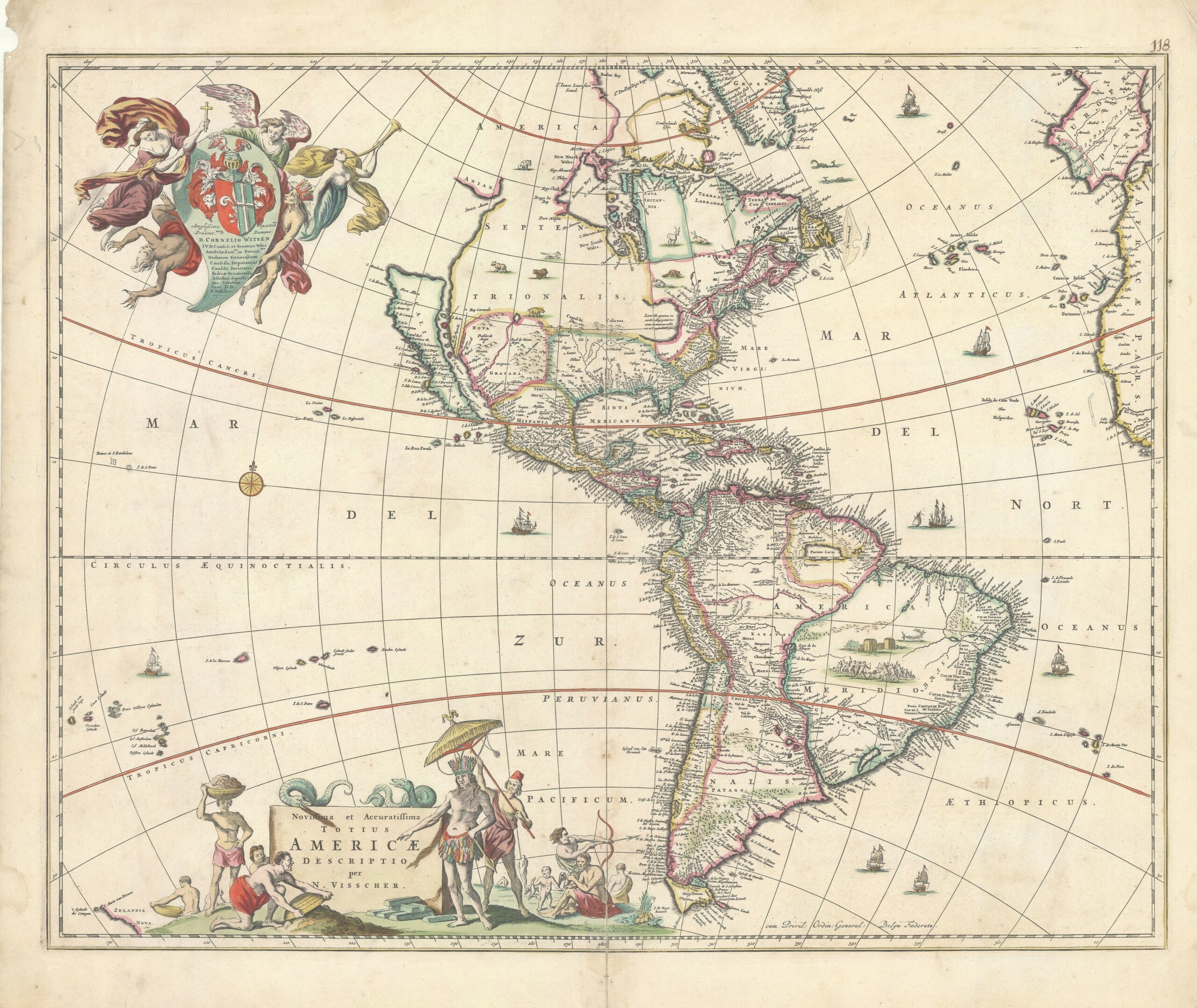
Visscher’s map of America is mainly based on two older maps, mainly Joan Blaeu’s 1648 wall map of the world. The west coast with California as an island follows the older map by Henry Briggs, with a different shape of the north coast. The date of the map is not easy to determine. In the dedication Cornelis Witsen is mentioned as burgomaster of Amsterdam – he had that function in 1653, 1658, 1662 and 1667 – and Director of the WIC, which he was since 1645. (Burden 1996, map 332; KAN 9000:51.2)
 (33) Novissima et accuratissima totius Americæ descriptio (Very new and accurate map of whole America). Amsterdam: Frederick de Wit, c. 1688 (first state c. 1672). 49 x 58 cm (OTM: HB-KZL 33.22.44)
Frederick de Wit was a mapmaker who was constantly altering his copperplates, so many of his maps have five or more different states. This map of America has at least eleven states, some of these have very small differences. This exemplar is in the sixth state. De Wit copied both cartouches from Visscher’s map (no. 32), but mirror-reversed. Instead of the dedication, De Wit has a text on the name and the discovery of America. It differs from Visscher in that, among other changes, the Great Lakes are added. (Carhart 2016, map 6; Burden 2007, map 465; KAN 9000:52B.6)
 (34) Novissima et accuratissima Septentrionalis ac Meridionalis Americæ descriptio (Very new and accurate map of North and South America). Amsterdam: Frederick de Wit, c. 1695 (first state c. 1672). 49 x 58 cm (OTM: HB-KZL 33.22.43)
About two years after De Wit made his sixth state of his America map (no. 33), the seventh state was issued: the first with major differences, such as the addition of islands in the Pacific and the coast of the ‘Terra Esonis’ in the north. Later he added the name Aovenliouaenronons between Lake Superior and Lake Illinois (eighth state) and around 1695, for the ninth state, the map got a new title. (Carhart 2016, map 6; Burden 2007, map 465; KAN 9000:52B.9)
 (35) Recentissima Novi Orbis sive Americæ Septentrionalis ac Meridionalis tabula per Fred. de Witt (Very new map of the New World or North and South America by Frederick de Wit). Amsterdam: Reinier and Josua Ottens, c. 1740-45 (first state by Justus Danckerts, c. 1700). 50 x 58.5 cm (OTM: HB-KZL 33.22.42)
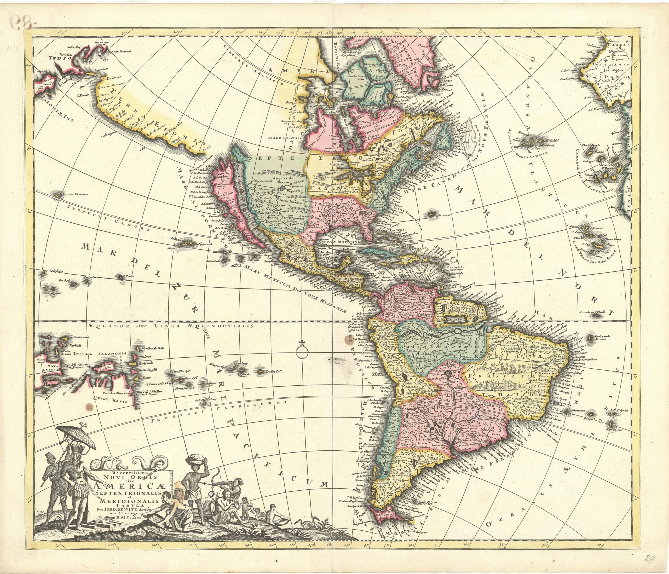
This uses, just as the De Wit/Ottens/Danckerts map of Africa (no. 28), the name of De Wit as an indication that it is good map and worth buying. We are dealing here with a later state of a c. 1700 Danckerts map, which was a copy of the ninth state of De Wit’s map of America (no. 34), where Danckerts omitted the text on America’s name and discovery and replaced that with a continuation of Terra Esonis to Japan. (Burden 2007, map 725; KAN 9000:533B.3)
 (36) America Septentrionalis novissima – America Meridionalis accuratissima (Newest map of North America – Most accurate map of South America). Amsterdam: Petrus Schenk I, c. 1703. 48 x 56.5 cm (OTM: HB-KZL 33.22.36)

One map, two titles! The map belongs to Schenk’s set of continent maps with the odd titles (cf. no. 8, 17 and 29). The cartouche of South America is adorned with native regional people with, in the background, a hammock hung in a high construction. The ‘north’ cartouche shows a sea god and other figures, whose relation with America is unclear. The map follows that of De Wit (no. 34), with several extra toponyms. (Burden 2007, map 722 ; KAN 9000:551A)
 (37) L’Amerique Septentrionale dressée sur les Observations de Mrs de l’Academie Royale des Sciences & quelques autres, & sur les Memoires les plus recens par G. de L’Isle Geographe. Amsterdam: Petrus Schenk I, 1708. 45 x 58 cm (OTM: HB-KZL 33.22.37)
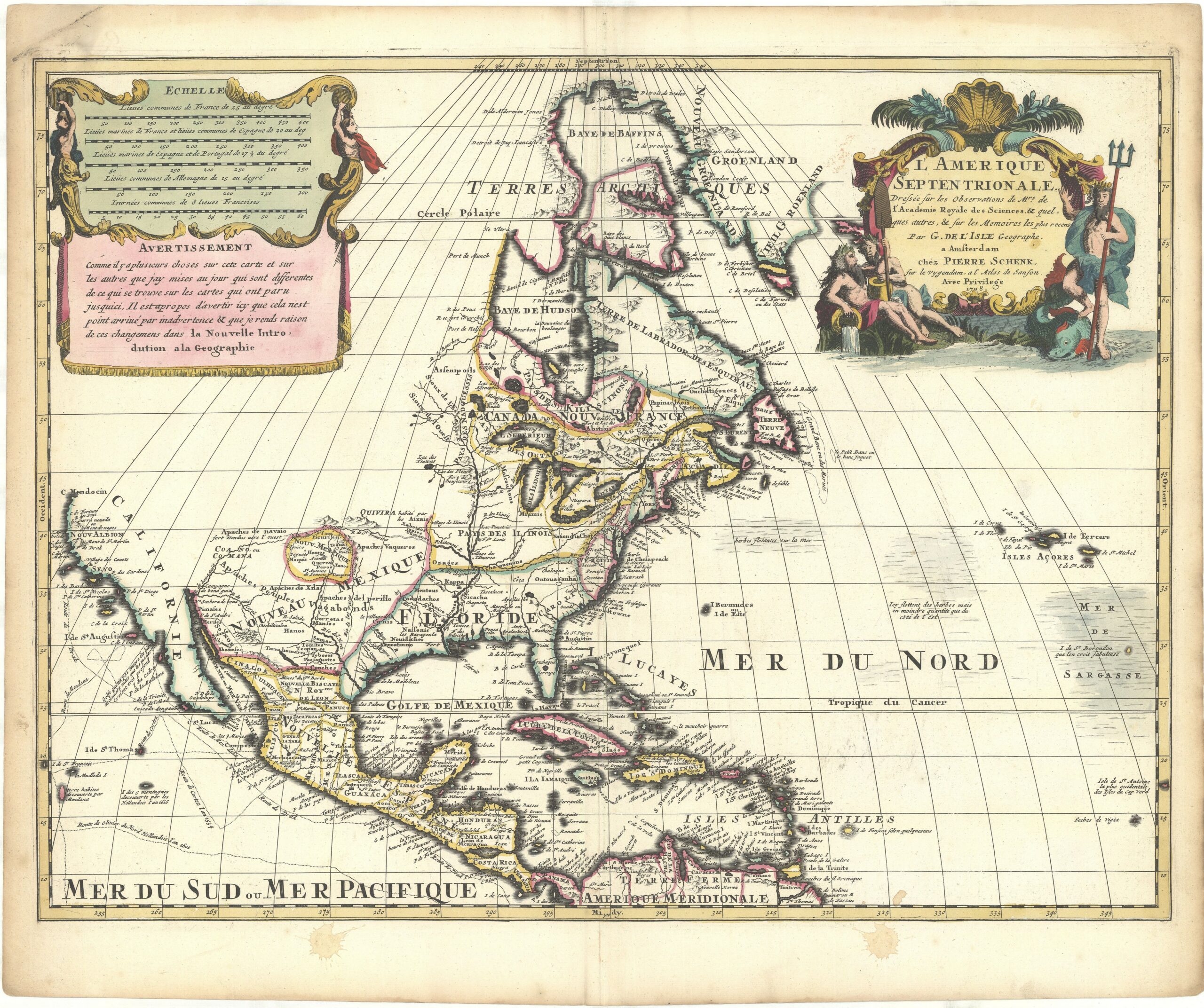
See no. 38.
 (38) L’Amerique Meridionale dressée sur les Observations de Mrs de l’Academie Royale des Sciences & quelques autres, & sur les Memoires les plus recens par G. de L’Isle Geographe. Amsterdam: Petrus Schenk I, 1708. 45.5 x 59 cm (OTM: HB-KZL 33.22.38)
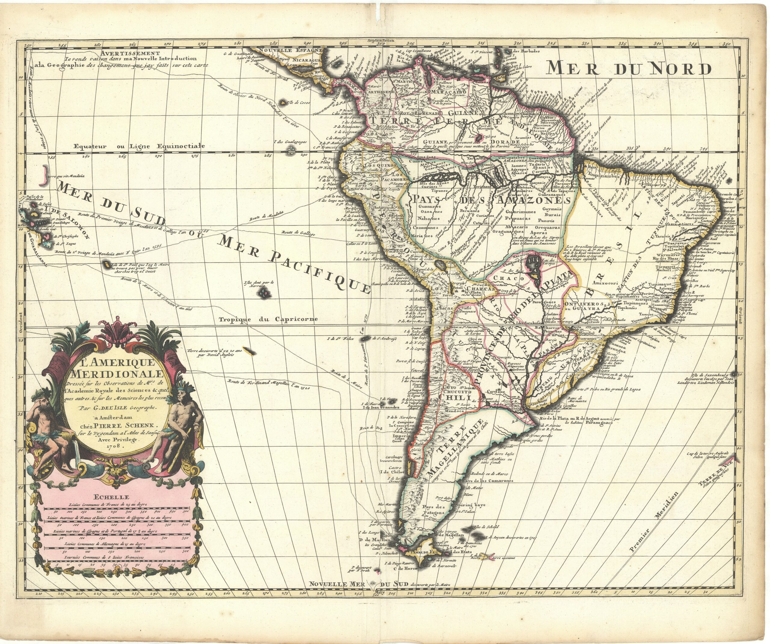
Except for maps of the whole continent of America, several mapmakers published separate maps of North and South America, and Petrus Schenk did this with the1708 map set of the continents. As stated in the title, both maps are copied from maps by the French cartographer Guillaume Delisle, who published the original maps in Paris in 1700. (KAN 9100:551.1 and 9800:551.1)
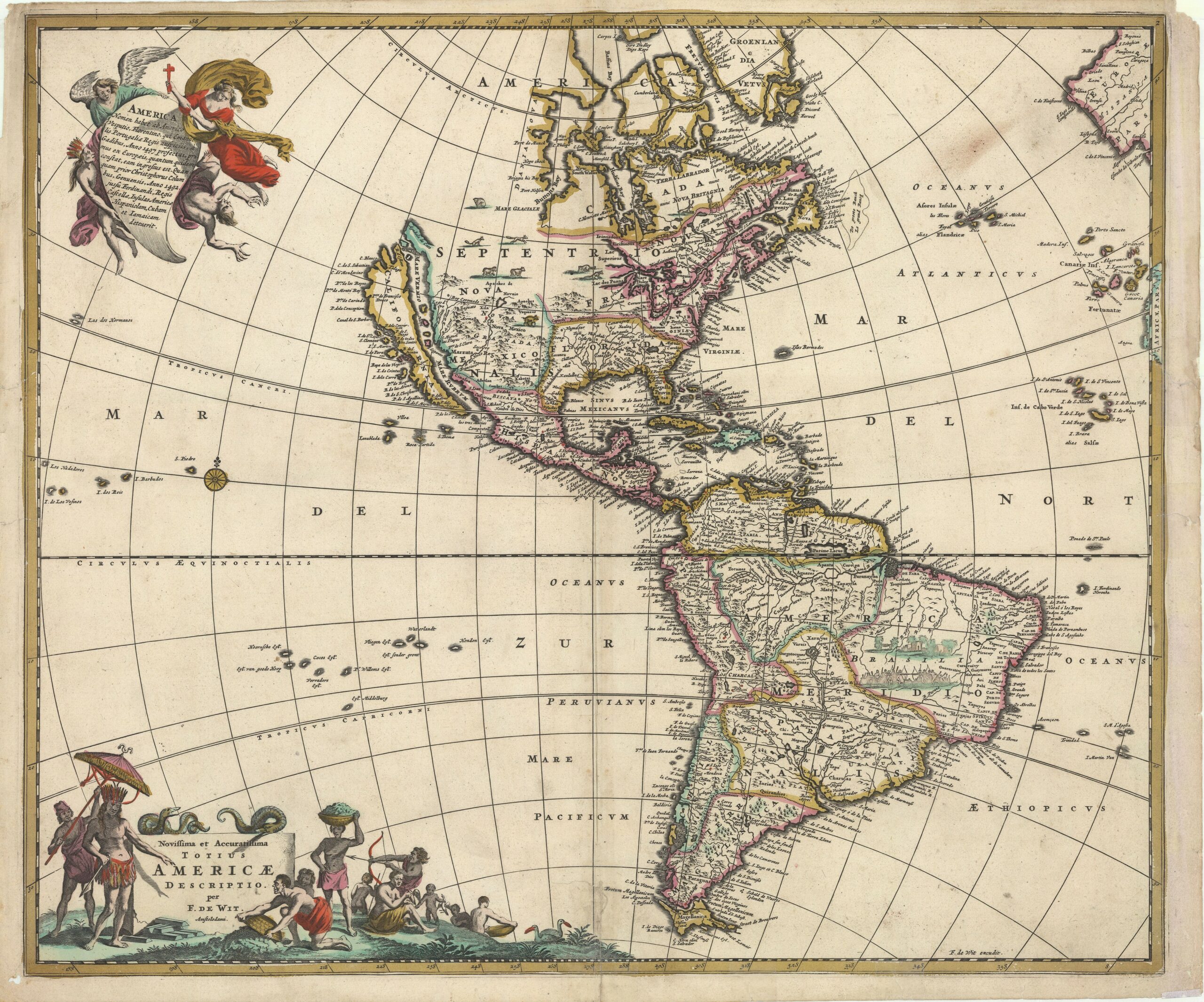
 (39) Amerique Septentrionalis; Carte d’un tres grand Pays entre le Nouveau Mexique et la Mer Glaciale… par le R.P. Louis de Hennepin. Amsterdam: Abraham van Someren, 1698 (first state by Willem Broedelet, 1697). 43 x 52.5 cm (OTM: HB-KZL 33.22.62)
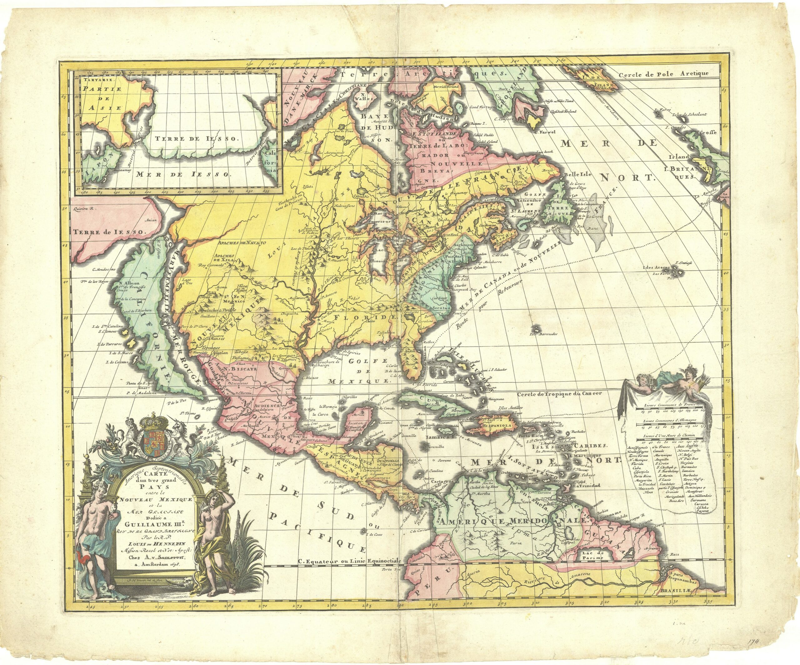
Louis Hennepin accompanied La Salle on his journey down the Mississippi in 1682, in search of a water route to the Pacific. This map accompanies his account and includes a new mapping of the Great Lakes and the first description of the Niagara Falls – on the map Saut de Niagara de 100 toise (a toise being 1.8 metres, makes the Falls three times too high at 180 metres). (Burden 2007, map 738; KAN 9100:599.3)
 (40) Hemke Hemkes Kz., Kaart van Noord-Amerika ten gebruike bij het onderwijs in de aardrijkskunde, bijzonder voor scholen, instituten en gymnasiën. Leiden: Noothoven van Goor, 1863. 108 x 99 cm in six sheets (OTM: HB-KZL 33.22.63 to 68)
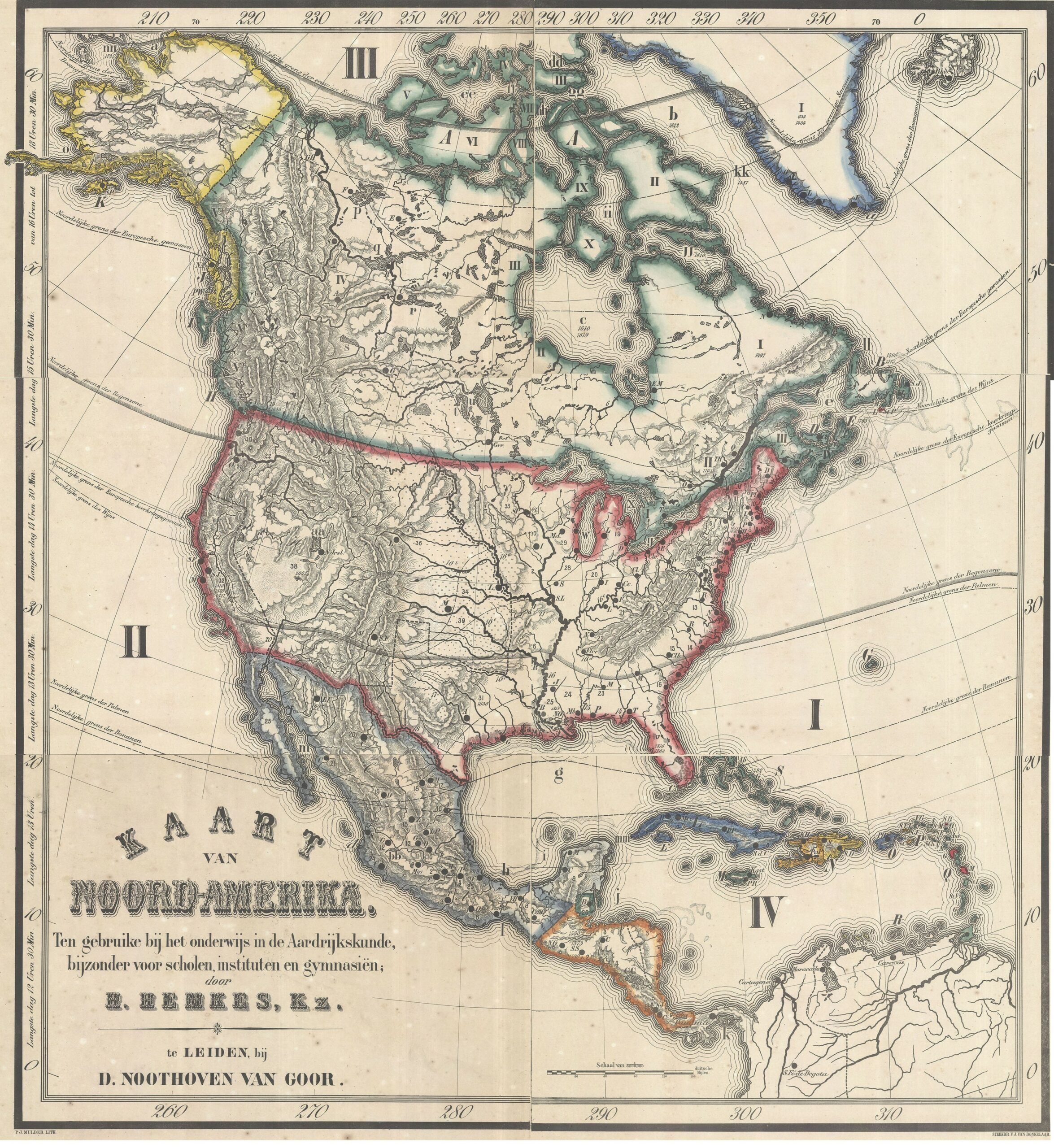
The Leiden publisher Dirk Noothoven van Goor advertised, in 1863, eight wall maps for school use, compiled by the teacher Hemke Hemkes. They are: The Netherlands, Europe, Asia, Africa, North America, South America, Australia and the World.
Some other maps
Since there are no maps of Australia in the Muller collection, we show a few maps of the world with Australia; and finally one of the largest maps in the collection.
 (41) Hæmisphæriorum tabula Carthesiana (Cartesian map of the hemispheres). Amsterdam: Petrus Schenk I, c. 1706. 49 x 59 cm (OTM: HB-KZL 31.01.26)
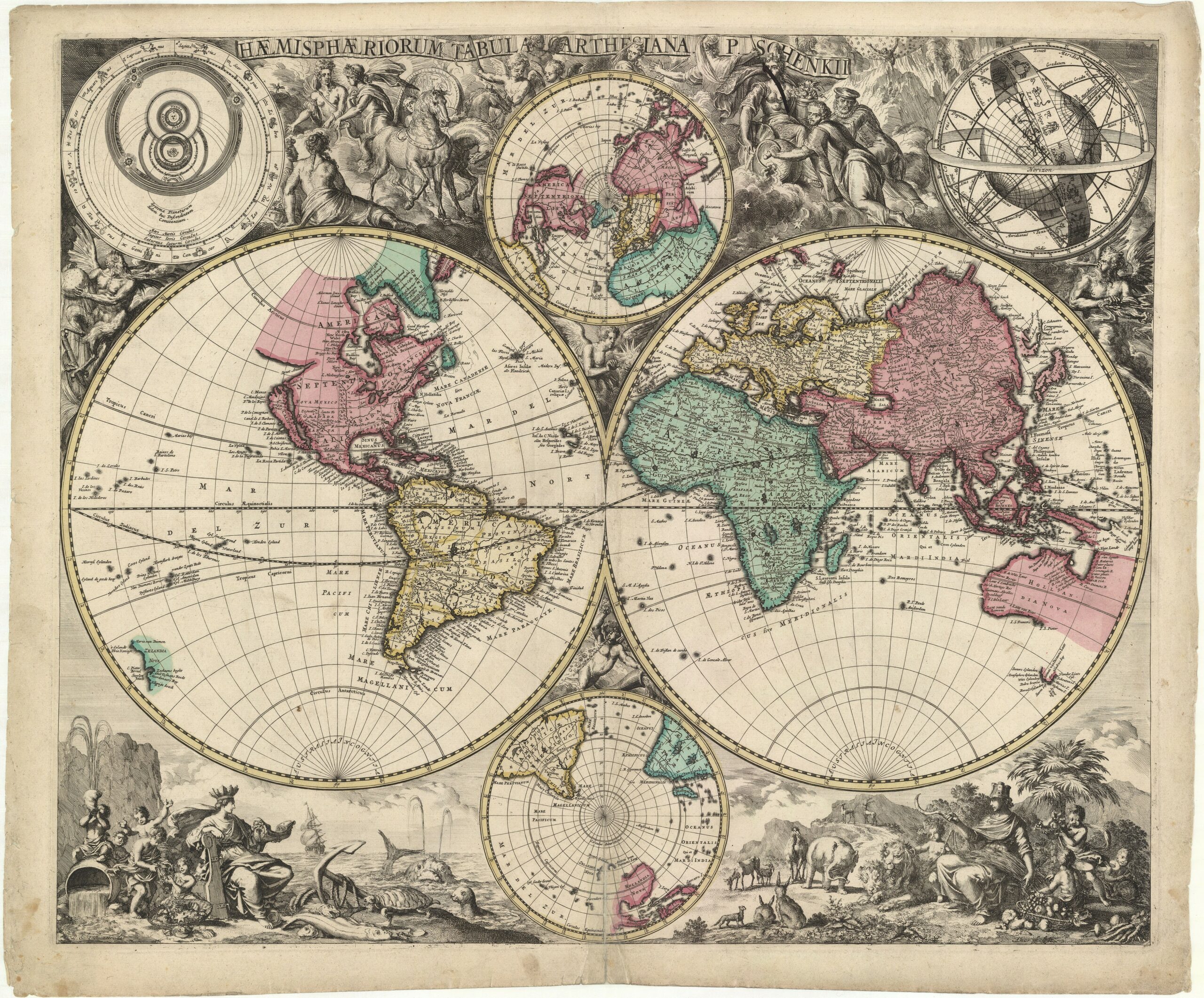
World map in two hemispheres by Petrus Schenk the Elder, engraved by Abraham Deur. Australia and New Zealand are shown as it was known since the voyage of Abel Tasman in 1644. In the upper part of the map are allegorical and mythological figures with, in the corners, two diagrams of the solar system and the earth with zodiacal and astronomical circles. In the lower corners are allegorical illustrations of marine and terrestrial life. (KAN 0001:551A.2)
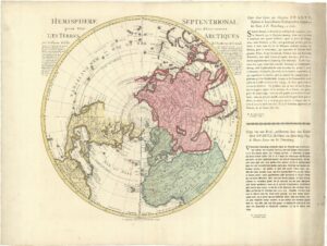 (42) Hemisphere septentrional pour voir plus distinctoment [!] les Terres Arctiques par Guillaume Delisle. Amsterdam: Reinier & Josua Ottens, c. 1740. 45.5 x 45 cm (OTM: HB-KZL 34.12.09)

See nr. 43.
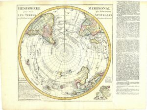 (43) L’Hemisphere meridional pour voir plus distinctement les Terres Australes par Guillaume de l’Isle. Amsterdam: Hendrik de Leth, 1740. 46.5 x 46.5 cm (OTM: HB-KZL 34.12.14)
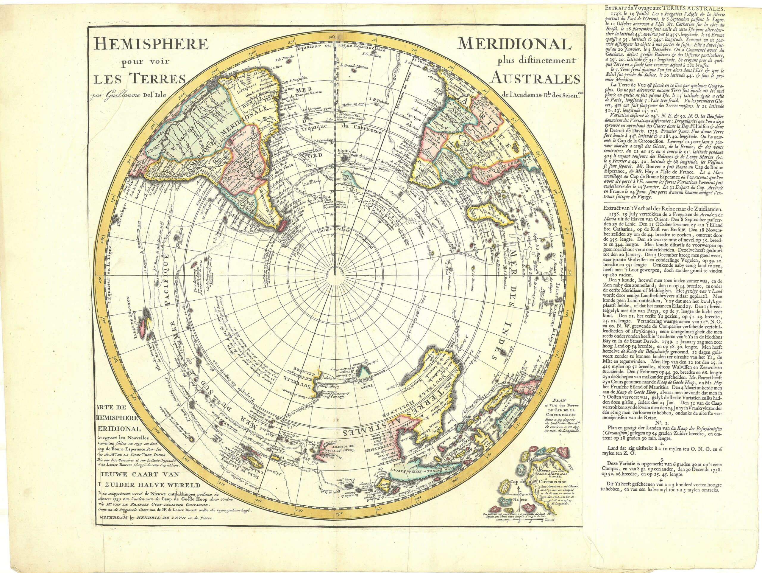
The French cartographer Guillaume Delisle published in 1714 two maps of the hemispheres: not the common eastern and western hemispheres, but the northern and southern ones. These maps were soon copied by the Amsterdam publishers Covens & Mortier, Reinier & Josua Ottens and Hendrik de Leth. Around 1740 these publishers updated these maps with new discoveries. On the northern hemisphere those by Martin Spanberg, a Danish captain in Russian service, and on the southern hemisphere by Jean-Baptiste Charles Bouvet de Lozier. A French and Dutch letterpress text explains this new information. (KAN 0002:57.2T and 0003:593.3)
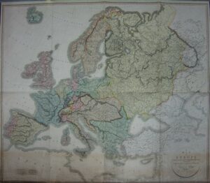 (44) A map of Europe, exhibiting its present political divisions drawn from the most authentical sources. London: John Cary, 1819 (first edition 1812). Four sheets, 130 x 149 cm (OTM: HB-KZL 34.12.20)

Large wall map showing the new political situation in Europe after Napoleonic times. The map was in 1812 dedicated to The Hon. Robert Clifford (son of Hugh, 5th baron Clifford of Chudleigh), who is further known as the author of a sketch of the Russian campaign in 1812, published by Cary. Since Clifford died in 1817 it is obvious Cary found no problem to dedicate his new edition to a deceased person.
(this map was too large for our scanning and photographic equipment, we made a photo with a hand-held camera)
Peter van der Krogt
(English text correction: Francis Herbert)
References
- KAN = Peter van der Krogt, Koeman’s Atlantes Neerlandici New Edition: Volumes I-V. ’t Goy-Houten: HES & De Graaf, 1997-… (V to be published 2020).
- Richard L. Betz, The Mapping of Africa: A Cartobibliography of Printed Maps of the African Continent. (Explokart Studies on the History of Cartography; 7). – ’t Goy-Houten: HES & De Graaf, 2007.
- Philip D. Burden, The Mapping of North America: A list of Printed Maps, 1511-1670, and The Mapping of North America II [1670-1700] – Rickmansworth, Herts.: Raleigh Publ., 1996 and 2007.
- George Carhart. Frederick de Wit and the first concise reference atlas. (Explokart Studies on the History of Cartography; 16). Leiden: Brill, 2016.
- Günter Schilder, Monumenta Cartographica Neerlandica, vol. VI: Nederlandse foliokaarten met decoratieve randen, 1604-60 = Dutch folio-sized single sheet maps with decorative borders, 1604-60. Alphen aan den Rijn: Canaletto/Repro-Holland, 2000.