Dissertaties Historische Kartografie / Theses History of Cartography
Justus Wekker
Karteringswerkzaamheden in Suriname
Historie, technieken en maatschappelijke achtergronden der karteringswerkzaamheden in Suriname sinds 1667
Diss. Utrecht 9 september 1983
Terug naar overzicht dissertaties / Back to overview PhD-theses
English Summary
History, Techniques and Social Backgrounds of the Mapping Activities in Suriname since 1667
a. History
The history of surveying and mapping in Suriname is interwinded with the colonial policy of -and the development of cartography in- the Netherlands.
From this point of view it makes sense to have this surveying and mapping history be preceded by a synopsis of the colonial mapmaking in the East-
and West-Indies. (Chapter 1).
Until the middle of the 19th century interest was confined exclusively to the coastal belt of Suriname but expanded to the hinterland when gold was
discovered in the upper reaches of the Marowijne-river in 1861.
Around the turn of our century seven scientific expeditions travelled up the great rivers and assembled topographical, geological and ethnographical, as well as botanical and zoological data. Nevertheless the vast stretches of land between the main rivers and south aal of the coastal area remained terra incognita until 1947, when photogrammetry was applied in mapping the country.
It is the intention of this publication to give an insight into the mapmaking, which underlies the disclosure of our country and the broadening of the
geographical knowledge of it. In our opinion no material will serve better or more powerfully than the many maps, which form the heritage of three centuries of hardy surveying.
Other resources from which we drew a great deal of our information are the many protocols, reports and accounts concerning the map material, extant in the archives of the Office of Lands, the Central Bureau of Aerial Surveying and the library of the Suriname Museum in Paramaribo.
In addition the standard work on the history of cartography in Suriname, “Links with the Past” by C. Koeman et. al. was extensively consulted.
b. The infrastructural design of Suriname.
The Surinamese rivers provided the ways into the interior since times out of mind. Also canals, which were dug by the slaves, were in use; while apart from the so-called communications-dams only a few roads appeared on the older maps of Suriname. With the introduction of small farming in our country also a road-system was initiated, while the gold-industry provided for the sole rail-road Suriname possesses.
The development of this infrastructure can be well traced on the maps of Cateau van Rosevelt (1882), the topographical map-series (1920) and the map of Bakhuis en de Quant (1930).
A spectacular opening up of the country by means of roads started in 1947 when the Welfare Fund programma came into being.
The so-called East-West communication-road and the forest-passage roads were established reaching from the Corantijn-river (west-boundary) to the Marowijne-river (east-boundary).
By means of seven airstrips built for the Grasshopper project (geological and mining research programme) also the remote interior became accessible.
c. Old length- and area-units
The many old measuring units in the Surinamese maps are brought here in the spotlight.
Especially J.C. Heneman called the attention to the several length-units on land and at sea current in his time (1784).
Unique are the two Amerindian units i.e. “Arie Ly” and “Lieke Poe”.
1. Summary of the cartographic aspects in the East- and West-Indies.
1.1.
A demarcation line was established by the treaty of Tordesillas, assigning all discovered countries and countries still to be discovered west of this line to Spain and east there-of to Portugal.
Around the middle of the 16th century Portugal dominated the commercial routes to the east, while Spain mastered the wealth of Central America and of a great deal of South-America.
Gradually also the English, the French and the Dutch undertook explorations, discarding the papal demarcation line.
The different Dutch enterprises sailing to the East in 1602 formed the chartered East-Indian Company (V.O.C.).
The V.O.C. had its own cartographers in men like Plancius, Hessel Gerritsz, Blaeu, De Graaf and Van Keulen (the latter remained in this function until 1795 when the V.O.C. was anulled).
Initially there was a need for charts, which in first instance were copied from the Portuguese, improved and completed.
A special committee was installed in 1787 with the aim to acquire better charts and to promote longitude-fixing on sea.
These charts only improved when Netherlands-East-India Geographic Service (later Topographic Service) was established and astronomical point-determination took place on several locations in the Archipelago. There-after topographic surveying followed and a Cadaster was installed.
1.2. The West-Indies
The oldest subdivision of the West-Indian islands dated back to the Spanish episode and is connected with the trade winds.
A more time-bound division is the one according to nationality.
1.2.1. The Caribbean sea, initially the property of the Spanish Crown was frequented in the beginning of the 17th century by Dutch sailing ships, the so- called “zouthalers” (fetching salt).
Also Dutch pirates penetrated this “mare clausus and started the clandestine slave-trade.
Then, in 1621, the chartered West-India Company (W.I.C.) was established having war-fare, buccaneening and commerce as its purpose. From this later on patronages originated, which caused the W.I.C. to become also a supplier of slaves.
1.2.2. The West-Indian Atlas of Thomas Jefferys dates back to 1775 and contains forty maps and charts (altogether) based on measurements while the compiler considered his Atlas as the first English “Pilot for the West-Indies”.
The maps are preceded by an extensive “Introduction , in which attention is given to the applied prime meridian for the map-projection, the astronomical observations, data and colonization, products, number of plantations etc. From this atlas a number of maps are discussed.
Another 5 maps compiled during the first half of the 19th century extant in Map and Plans in the Public Record Office (by P.A. Penfold) call for attention.
Important collective works of British Cartography are among other the Blathwayt-atlas and the map of Popple (1733).
From this Blathwayt-atlas the map of the island of Monserrat (1673) is discussed, according to J.D. Black’s commentary on the Atlas.
1.3. Netherlands – Antilles
1.3.1. There were maps of these islands at a very early data, most of them however only in outline. First, six synoptical maps of the Netherland Antilles will be brought in the spotlight, after which some specific maps of the islands will be separately discussed.
- a. Thirteen maps of Curaçao, the oldest by Johannes de Laet (1644) and two from the Sevilla-archives (1634) will be reviewed.
Also geological-, topographical- and photogram metrically composed maps are mentioned. - b. Besides the topographical map-series of Aruba, maily the maps concerning the gold-exploration on this island are discussed.
- c. Of Bonaire we discuss the map, which served for the auction of land-parcels on the first of September 1868 along with the topographical map and a geological map from 1887.
- d. The oldest known map of St. Maarten (Martin) is the one compiled by Gerard Hulst van Keulen (1791); much earlier (1495) Juan de la Cosa made a map on which this island appeared. Furthermore we mention the topographical map of Samuel Fahlberg (1791) State-Surveyor for both the Dutch and French part of the island,
some maps and sketches of the saltines, the topographical map of around 1912 and the 1950 geological map. - e. On the Tuninean map (ca. 1523) we find St. Eustace and Saba: the latter otherwise being treated stepmotherly by the cartographers. Of St. Eustace there are among others a map of Reinier Ottens (1775), one of the Samual Fahlberg (1830) and a topographical map of around 1912. Although no map of Saba was known in the Netherlands, there proved to be a printed map of this island on St. Thomas, designed by the administrator of Saba Mr. Statius van Eps (1883).
There is no topographical map of Saba and the first geological map was compiled in 1958. During the fifties of our century the U.S. made an
aerial survey of this island, while K.L.M. aerocarto produced a contour-map of Saba in 1959.
1.4. Berbice, Essequibo and Demerary
1.4.1. The map collection for the Venezuela-British Gyana Boundary Arbitration (1897) contains many maps of Guyana including eleven historical maps, illustrating the European possessions between 1597 and 1803 (1814).
Between the regional maps of this area there is a manuscript map of A. Maas (1706), a map of Storm van ‘s-Gravesande (1748) and one of J.C. Heneman (1773-1775). Furthermore there are many maps dating from the 18th, 19th and 20th century, from which some are discussed.
1.5. French-Guiana (Cayenne)
1.5.1. Charts and maps.
Plantation maps as known of Suniname and (British Guiana) now Guyana, are not existant in French Guyana; their charts however are similar to those of our country. Several charts from the 17th, 18th and 19th century are mentioned while some 14 maps, among which, that of du Val d’Abbeville (1654), BuacheMentelle and Poirson between 1802 and 1821 along with that of Van Panhuys (1908) are discussed.
2. The period of the (Dutch) West-India Company and the Chartered Society of Suriname.
(The maps for the use of the plantation-economy 1671-1795)
2.1. Land-issue policy
The West-India Company had to establish stable agricultural settlements on the conquered places, proper management of the colony and ground rules for the exploitation of the land. In the beginning colonists were given a free piece of land, with the legal status of ownership. Warrants were isued to the planters, containing the only obligation of bringing the land under the plough and to register with the Secretary.
Many planters misused the freedom and seized disproportionate areas of the riverbanks and thus brought expansion possibilities into grave danger. In 1685 a maximum area of 1000 acres was put on plantations, as well as a ruling on the breadth of the river-frontage and depth of the parcel. The recipient now had to pay a yearly rent and was required to have his parcel surveyed.
To get an insight into the land-issue, cadastral maps were compiled (F. de Wit, J. Sas en A. de Lavaux).
As appears from the diverse proclamations and “reminders” the requirements of surveying and registering the land were not always complied with.
The obligation of surveying was also laid on lots in Paramaribo (year of foundation 1683) (city plans: De Wit, Ottens and G. Palm).
2.2. Some fundamental maps of the 17th and 18th century
As early as 1667 the surveyor Willem Mogge was sent to Suriname to make a “pertinent and accurate map of the whole of Suriname”.
What was meant as the whole of Suriname is described in the title of the map. This map appeared in 1671, showing the names of the owners of the sugarplantations in Roman letters.
Mogge’s map was followed in 1686 by that of the “Labadisten”, from which one could surmise that the number of plantations has risen to 148 (Mogge showed 100). Further it shows that the entire Para-river and the left-bank of the Suriname-river have been abandoned, most probably due to the raids of Amer-Indians in cooperation with the Maroons. One cannot set a high value on these maps as surveying documents as contrasted with the cadastral map of F. de Wit issued in 1688.
2.3. De Lavaux and his work
With his biography Alexander de Lavaux is introduced and his map of 1737 extensively discussed.
Still four editions of this map were issued, the latest around 1770 by P. Schenk en Zoon, the merits of which are entered into.
2.4. The work of J.C. Heneman
In the inventory of P.A. Leupe (1867) note is taken of a number (40-odd manuscripts) of maps of J.C. Heneman. We dwell for some time on his 1784 map and the manuscripts of his undated 140-sheets map (enlargements).
Based upon a closer inspection of some of these sheets and comparing them with wellknown historical and other facts, we came to the conclusion that this 140-sheets map was completed after 1794. Furhter, that it took Heneman some 10 years to finish his enlargements and not as Sypesteyn assumed that Heneman completed his 1784 map in that short time.
3. Mapping in the 19th century (Maps serving the gold-exploitation)
3.1. A transitional period
Although, on one hand, the plantations along the upper courses of the rivers were abandoned, on the other, the plantation-economy became concentrated along the lower reaches of these rivers and in the so called “New Colony”. The last was settled primarily by English and Scots of which the toponyms in Nickerie and Coronie are silent witnesses (British interregnum 1799-1818).
The decline in agriculture was due to war in Europe, the loss of the sugar- market because of the Continental System, while our cotton could not compete against that of the USA.
The plantation economy received its death blow with the emancipation of slaves; surveying in Suriname also hitting a low-point at that time. In order to put the economy back on its feet small farming was taken up and attention was paid to the gold exploitation.
The activities of the landsurveyor W.L. Loth have contributed greatly to this exploitation.
3.2. The maps of Loth
Loth surveyed and mapped among others three traverses along which the Governement issued gold-concessions (grants).
The first traverse connected Brokopondo on the Suriname river with Pedrosungu on the Marowijne river.
The second started on the same spot on the Suriname river and ran in a western direction to the Saramacca river; while the third reached from upper-Tempati river to Boschland, also near Brokopondo.
A synopsis of the situation regarding the granting of gold exploitation is given in a map of Loth from 1879 (scale 1:40.000).
He surveyed also two traverses in the Saramacca district. His work has been set down in reports in several volumes of the (T.A.G.) Journal of the Dutch Geographical Society, along with the activities arount the gold mining.
Finally Loth surveyed another traverse in 1892 running between the Tapanahoni river and the Sara creek, after the area between the Tapanahoniand the Lawa-rivers was unconditionally declared Suriname territory by the arbitral judgement of Czar Alexander III of Russia.
Another synopsis of the 163 plantations still in cultivation and the land- grants on gold and other minerals is given in the map of J. Kuyper (scale 1:800.000) and published after 1882.
As coping-stone on the activities of Loth we mention his synoptical maps from 1889 and 1899 (both on the scale 1:1.000.000).
In his second map (1899) Loth corrected some mistakes he made concerning the boundary with (British) Guyana and indicated the New River (upper-Corantijn) as the border.
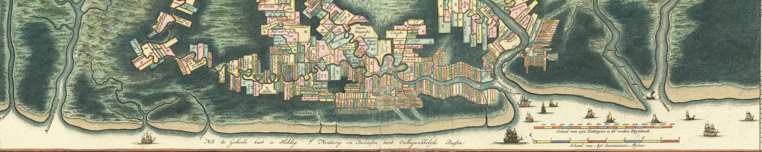
3.3. Cateau van Rosevelt and his map
First of all a concise summary is given of the geodetic qualities of the selfmade man Cateau van Rosevelt, where-after his map from 1882 is extensively discussed. It took him and the luitenant J.F.A. van Lansberge 19 years to complete this map.
The original manuscript map, consisting of 31 sheets on the scale 1:100.000, was issued later on on the scale 1:200.000 (10 sheets).
The printed series lack the itinerary of the surveying trips, the geographical coordinates derived from astronomical observations and the several crops distinguished by color, all of which we find on the manuscript series.
The expansions of Paramaribo from 1784 till 1882 are also discussed along with the atlas of A.J. Meyer (1885) containing the “Figuratieve platte grond der stad Paramaribo”. (Figurative plan of the city of Paramaribo).
3.4. Astronomical observations
The very poor data concerning the astronomical observations in Suriname Id not start in 1744 with the determination of latitude by Charles de la Condamine on the square in front of the Court of Justice in Paramaribo.
Appearing in sequence of time are some hydrographical charts in which latitudinal and longitudinal determinations are indicated and the “Stenentrap” (compass-rose on the stone wharf) is introduced.
The number of astronomical observations increased as Cateau van Rosevelt got on with his measurements and Lieutenant van Stockum (1911) performed observations downstreams of the main rivers on behalf of the topographical mapping of northern Suriname.
Lack of adequate time-determinations results in poor longitudinal fixes; both mr. P.W. Sachs (former staff-officer on board the naval vessel Z.M. Suriname) and Prof. dr. J.J. Müller criticize the methods employed. Finally in 1947 new observations were conducted employing the method of simultaneous determinations of latitude and longitude.
3.5. A review of magnetic declination in Suriname
Comparing maps before 1801 with maps of later date it appears that the plantation-boundaries (dikes, dams) were not oriented according to the true north. For the first time surveyors were ordered that “the four cardinal dihas rections must be shown on the maps according to the true bearing in an inf the struction dated December 17th, 1782. W.L. Loth statet that the surveyors interpretation of the term “true bearing” was the direction according to the compass because the north-oriented boundaries varied from the present-day (1905) indications of the compass-needle by 5o-7o. Using some publications, maps and reports a summary is given of the course of the magnetic declinay the tion for Paramaribo since 1500 recording the greatest eastward deviation (7½o) around 1650, while in the middle of the 19th century the zero-isogoand- nic line ran over Paramaribo.
Shortly after the initiation of the gold-industry in 1875 a new instruction for surveyors was drawn up (september 21st, 1877 no. 9) in which it was ordered (art. 11) that the true and magnetic north should both be indicated on the maps of measured parcels.
This however was not complied with. A juridical decision of the Court of Justice (November 15th, 1902) solved this problem
Surveyors applied to the Governor in requests concerning this matter. This resulted in putting into use the “Manual for determining the corrections of a boussole and setting the time”. Since that time surveying has been conducted according to the true north.
A few years later (1905) a Surveyor’s Association was founded and a course designed to make the surveyors more competent in their profession.
3.6. Surveyor’s Instructions
From the moment that Willem Mogge, the first Dutch surveyor accepted his assignment, he received surveying-instructions.
His successors were als bound by certain directions such as those of August 1st, 1724; of December 17th, 1782 and September 21st, 1877. Another instruction was issued on April 27th, 1915 giving directions concerning measurements and staking out plots granted in concession for certain purposes. The next instruction dating from July 6th, 1927 pertained to the prosecution of the profession of landsurveyor in Suriname.
Art. 8 of this instruction prescribes a separate ruling of the ways how the surveyor has to perform his function.
4. Thematic and technical mapping
4.1. Hydrographic surveying and mapping
The safety of navigation demands reliable charts more so in connection with the phenomenon of the movement of mudflats along the Surinamese coast.
A series of new charts are issued by the House of van Keulen in 1785, showing great similarity to the Heneman map from 1784. Not very surprising, considering the fact that the Heneman map is also issued by Van Keulen. What, however, strikes us as accidental is the toponym “Abrina , a village on the Marowijne river, long before Kappler, who is said to be the founder of “Albina”, came to Suriname.
The chart of E. Thomson and others from 1783 still indicates the Saramacca estuarium as shown inaccurately on the map of Lavaux from 1737.
An important contribution to the hydrographic charting of Suriname was made by the Dutch Navy. As an example the chart of naval-lieutenant J. Vos from 1845 is discussed; with this chart a tradition starts for years on end (40 years). Another chart, that of F.A.A. Gregory appeared before the footlights (1860), followed by an explanation of the chart issued in 1887 by the Marine Department. The scale of these charts was 1:750.000 which became traditional on charts of the Surinamese coast.
Apart from these synoptical charts of the coast, also charts of the separate rivers and river-entrances were compiled mostly on the scale 1:75.000 using the Mercator projection and giving heights and depths with mean sealevel as a reference (2-3- foot above low-water spring).
The most recent hydrographic surveys took place between 1967 and 1973, while the latest charts were issued in 1976.
4.2. The poly-thematic map of Zimmermann 1877
Zimmermann, using the manuscript map of Vermeulen, issued this map on which all economical, geological, pedological and historical informations of the Suriname-river basin is given in a surveyable fashion. The mentioning of the local (Sranan) toponyms, along with the official geographical names is very unique.
Consulting the map it appeared that the plantation-area along the Suriname river dwindled down to only 2329 ha (33 plantations) where 2835 local laborers and 1396 immigrants were employed. Attention was also given to hydrography and the gold-industry.
4.3. Other thematic maps
4.3.1. In many instances these were produced to illustrate reports and through that to awaken interest in our country.
From 1899 for instance there is the map of Loth giving an overview of agricultural land-area, gold-exploitation and the balata-industry along with the projected steam-tramline through those areas. An other example is Kietzmann’s map (1905), the first map that we know with certainty to have been printed and published in Suriname. Kietzmann is chiefly concerned with the shrinking agriculture areas, the actual gold concessions and the rise of the balata industry. Also noticeable on this map are the indications of the Savannah belt in Suriname.
4.3.2. The map for the World Exhibition 1910
A Dutch Commission was established to gather data to be used in the world Exhibition at Brussels in 1910.
Although data were available concerning the economy, such as agriculture, balata-exploitation, demography etc. these were not featured on the map. Much space however was dedicated to the spreading of schools and churches of the Moravians and Roman Catholics.
4.3.3. The “balata” map of 1912
This paragraph gives us the opportunity of going into another aspect of the Surinamese economy, quoting one and another from the book by Struycken de Roysancour and Gonggrijp: The balata problem in Suriname (het balata vraagstuk in Suriname).
The authors criticize the extant legislation on the balata-industry especially concerning the surveying and cartographic aspects. The map itself executed in colours and as far as the content goes is identical to the Exhibition-map of 1910 supplemented with indications concerning the situation of concession-grants (exploration and exploitation).
A separate map on the scale 1:1 million was issued in connection with the ordinance of 1914 (G.B. 1914 no. 51). This map, entitled “Map belonging to G.B. 1914 no. 51”, is a reduction of the map of Spinet (1913) and contains a division in 63 blocks, each with a Roman number and the acreage.
4.3.4. The synoptic geognostical map of K. Martin (1888)
Prof. K. Martin made a first experiment of some geological formations of Suniname in two synoptical maps.
As a base he used the map of Cateau van Rosevelt (1882). He encountered some difficulties in indicating correctly the boundaries between distinct geological formations because of inadequate mapping especially in the Corantijn river.
5. Mapping in the first decade of this Century (1899-1911). (The map in service of science).
5.1. The scientific expeditions (1905-1911)
As a predecessor to the real expeditions mention is made of the mapping of the upper reaches of the Nickerie river by C. van Drimmelen (see: T.A.G. XVI, 1899).
The intention of the scientific expeditions, was above all the procurement of more geographical data on the interior of Suniname. Interest was taken in the mountain-systems, especially because of the possibility of using their tops for the mountain triangulation.
The first expedition, the Coppename expedition, laid the foundation for the first circumferential measurements. These were taken from the Voltz- and the Van Stockum mountains while the oronyms Wilhelmina mountain, Emma ranges and Hendriktop, originated from L.A. Bakhuis (leader of the expedition)
The second expedition went up the Saramacca river, with the assignment to climb the Jan Basigadotop and take bearings therefrom. Thereafter the mountain panorama’s were to be seen from the Hendniktop and finally to climb a third mountain in the source-region of the Saramacca river, which should yield further data of the Wilhelmina range. Van Stockum, the leader of this expedition could already conclude from the observations made, that the Wilhelmina range and the Tumuc-Humac mountains ware separate mountain ranges.
Although not yet known by that name and hardly discernible because of the clouds, the “Tafelberg was detected.
Apart from topographic data also geological, botanical and zoological material were gathered.
The Gonini-expedition, the third in sequence, chose this region for her investigation in connection with the construction of a railroad from Panamanibo to the Lawa river. New ononyms were added to the list, such as Manlobi, the Goeje mountains, Knopaiamoi and the Lely mountains.
Also hydronyms were added such as the Emma- and the Wilhelmina rivers as tributaries of the Gonini river. On the Kniopaiamoi, near the Litani river large magnetic anomalies were recorded. In addition to large quantities of botanical material and stonesamples a hundred-odd Indian tools, as well as impressions, of bush-negro wood-carving designs were gathered.
The fourth expedition, known as the Tapanahony-expedition, was commissioned to make connecting links between the mountain tniangulations of the Saramacca- and Gonini-expeditions and further to reach and reconnoitre the source area of the Suniname river through a journey overland. The Palumeu and upper Tapanahony were mapped, whereby significant anomalies were registered near the Magneet rots (magnetic-rock) and near the Kasikasima.
To make the connecting link between the mountain tniangulations four peaks were scaled: Tebu, Magneet rots, a peak of the Kasikasima and a peak near the Papadronsula (rappid in the Palumeu river).
The positioning of Tebu, derived from the western system compared with the position of the same top triangulated in the eastern system gives a discrepancy of 31″ in latitude and 1’20″e; in longitude.
After the Tapanahony came the Tumuc-Humac expedition which was assigned to reach the source area of the Palumeu and from there on reconnoitre the area between these sources and the head waters of the Corantijn. Further in connection with the boundary determination between Suniname and Brasil as much information as possible relating to the watershed was to be gathered.
The results of this expedition did not lead to any spectacular map work.
As usual some attention was given to investigations concerning geology and anthropology; also an expanded word-list to trading terms between the Ndyuka’s and Trios, as well as a list of Ndyuka words, which differ from common Sranan, were composed.
The Suriname-expedition – the sixth in the set – had to reconnoitre the upper Suniname river region, connect the mountain-tniangulations of the Tapanahony and Gonini-expeditions with those of the Saramacca and Coppename expeditions, to travel – if possible – oven the watershed between the headwaters of the Suniname river and of the Corantijn, and reconnoitre the latter. (This last mentioned task was not realized).
The 7th and last of these expeditions, the Corantijn-expedition had to investigate the Corantijn region, especially the stretch of land lying east of it.
The compilations of the findings of all these scientific expeditions in one map, published originally in 1913 and re-issued in 1927 was done by Spinet, chief of the Surinamese Suryeying Brigade. This map can be seen as the first to render the complete framework of headwater-courses and the most outstanding mountain ranges in their proper relationship to each other and oriented on the true north.
A practical benefit of this map was its use as a basis for a synoptical map for the division into blocks of the balata-exploitation areas.
6. The period of the Survey Brigade (1911-1930)
6.l. & 6.2 History, Plan en Execution of the topographic work
In the year 1911 Spinet was installed as Government-Surveyor and given the task of bringing about improvements in the cadastral and topographical situation in Suniname.
To obtain “fixed-points” to which the surveys could be related, astronomical observations were carried out at various places in the coastal area.
These points were tied together with base-lines (traverses) hooking up with property-surveys, thus serving cadastral purposes and topographical m easurements. Between 1912 and 1919 a total of 2534.2 km of baselines were measured; thereafter Paramanibo was surveyed.
By 1919 a total of 66,522 ha was surveyed and mapped on the scale 1:10.000 and reductions made on the scales 1:50.000 and 1:200.000. However only 17 sheets (from the 320 planned were printed (including one of Paramaribo). As a datum for the vertical measurements in these surveys the lowest known water level on the tide-gauge at Beekhuizen between 1904 and 1909 was taken. The task of Spinet included the connection of the mountain- triangulation network with the astronomical fixed points in the coastal belt.
6.3. Geodetic base for a Cadastre of Paramaribo
At the intersections of all streets in Paramanibo, heavy concrete markers were set up, half a meter below groundlevel.
The lines connecting these points together formed a dense net which provided the base-lines for the measurement of the lots in the city.
The project, started in 1913, was stopped in 1915, leaving everything thereafter untouched. By then the net-work was finished but only a few lots had their boundaries fixed.
6.4. The map of Bakhuis and De Quant (1930)
With the help the basic data i.e. the results of the scientific expeditions, 26 astronomical stations set up by Van Stockum in 1911 and 1912, the work of the surveying Brigade and corrections in longitudinal, observations made by Kremer in 1927 using precise time-measurements, Bakhuis and De Quant in 1930 issued a synoptical map in the scale 1:200.000 in 16 sheets.
An abundance of geographical names makes this map extremely important, the nomenclature being almost all still in use to day. This map had become urgently needed in connection with the granting of concessions, since the official map for the balata industry, that of Cateau van Rosevelt, appeared inadequate.
The Bakhuis map constructed according to the Mercator projection serves even today as the official map for requesting and granting parcels of land for concessions of any type.
7. The period of aerial surveying (1943-present)
7.1 The first photogrammetric surveys
The US Airforce conducted an aerial survey in Suniname in 1943 for the purpose of making aeronautical maps. (World Aeronautical Chart). The survey was done according to the tnimetrogon system while a comparison of the thus produced maps with the one to a million map of Suniname from the Central Bureau for Aerial Survey (C.B.L.) clearly points out the short-comings of the beginning phase of photogrammetny.
An aerial survey of northern Suniname of higher quality was performed in 1949 by the Cartographic Service of KLM.
A total of 10,419 photos was taken in the scale 1:40.000.
As a necessary offshoot of this commission for the systematic photographic recording, the C.B.L. came into existence (February 7th, 1948). The frame work of surveying was formed by 26 astronomically fixed points according to the Gauss-method; while for orientation on behalf of the aerotraingulation traverses were measured.To obtain the elevation of the ground-control-points (astropoints) barometric observations were conducted at the site and along the rivers, using the vertical datum of the Office of Lands-being 1,50 m below mean sea level.
The maps composed from the aerial photos were executed in the system of the stenographic projection; having as central point the intersection of the meridian of 55o41′ West Longitude and the parallel of 40o71′ North Latitude. All geographic coordinates were calculated on the Bessel spheroid. An additional commission for mapping the southern part of Suniname (below 40o of latitude) followed in 1956.
7.2. Airborn methods on behalf of the geodetic frame work
To set up a triangulation network of primary order, consisting of 52 points equally spread throughout the country, the aerodist system was applied.
For orientation purpose this net was tied to some Hiranpoints. During the first and second phase of the densification of this net the helidist method was used and ground controlpoints were measured.
In areas where use of a theodolite was impossible, a modified helidist method, known as “multidist was applied. Still other problems presented themselves related to the fixing of ground-control points, whereby neither helidist nor multidist could be used. In those cases terrestrial methods such as traversing and/or tnilateration were applied.
Height-data were established partly by first order leveling and partly by barometric measurements.
The adjustment of the aerodist net only, dit not provide a satisfactory result in all respects; an integral adjustment however of aerodist and helidist measurements together yielded acceptable values.
The geographic coordinates finally obtained by adjustment and scaling on the Hiran-net were converted into the U.T.M. system based on the International spheroid.
In this system Suniname falls in grid zone 21, with 57o West Longitude as the central meridian, which brings a large part o( the country inzone 22. In order to project the whole area of Suniname in one zone and to apply the scale-progression harmoniously, the central meridian was moved to Xo=55o41′ W.L., with a scale factor (ho=0,99990).
7.3. Doppler Satellite Positioning
As third phase in the densification on behalf of the aerial mapping the south-east corner of Suriname could finally be surveyed in 1977, using the Doppler translocation system. According to the required accuracy of the coordinate-values, the short arc geodetic adjustment was also chosen. The standard-deviations of the coordinates in the World Geodetic System 1972 (W.G.S. 72) related to the base-station (i.c. Palumeu-airstnip) varied between 0,085 m and 0,604 m. In order to incorporate the Doppler points into the Suniname system, the W.G.S. coordinates were converted to the International Spheroid (datum-shift) and transformed into the modified U.T.M. (central meridian at 55o41′ W.L., scale factor ho=0.99990).
7.4. Primary levelling
The need for establishing a uniform vertical datum became urgent when in the early fifties of this century the Brokopondo Project and other activities which would influence hydrology down streams, were being planned.
In September 1957 a uniform datum was introduced referred to as the Normal Suniname Datum (N.S.P.), being mean sea level, as measured at the mouth of the Suniname river in 1956.
This datum was spread through careful levelling and monumented by benchmarks throughout the northern part of the country. Later during subsequent surveying in west and south-east Suniname, this levelling-net was expanded further, totalling about 5000 km with bench-marks at every 2 km (approximately).
7.5. The new topographical map 1:50.000 (Central Bureau Aerial Surveying)
The geodetic frame work and levelling discussed earlier in this chapter were pnincipaly intended to serve as a basis for a new topographical map of Suniname on the scale 1:50.000.
To incorporate the new map into the South American Continental System, the formerly used Bessel spheniod is replaced by the International (Hayford) spheroid, and the modified U.T.M. is going to replace the up till now applied stereographic projection.
7.6. Gravity Surveys in Suniname
The history of gravity-surveys in Suniname starts in 1945 with a single observation by Harding at Zanderij-airport.
A more extensive survey in connection with the International Geophysical year (1957-58) was conducted by Veldkamp (19 stations) followed by an extension in 1958 (115 stations).
The very promising results from these surveys gave the impetus for a regional gravitational survey by Van Boekel in 1960.
The area investigated on that occasion comprised the whole northern part of the country.
The survey resulted in a gravitational-anomaly map of northern Suriname with intervals of 5 mgal.
An extension of this map in a northerly direction i.e. on Suriname’ s continental shelf took place in 1966 and 1969 by naval vessels; the iso-anomaly chart resulting from this survey was linked to Van Boekel’s observations.
Small local expansions of this gravitational network were conducted in the region of the projected Kabalebo storage-basin and in south east Suriname; the last was done in connection with the Doppler measurements.