Dissertaties Historische Kartografie / Theses History of Cartography
Frans Scholten
Militaire topografische kaarten
Militaire topografische kaarten en stadsplattegronden van Nederland, 1579-1795
Diss. Utrecht 7 April 1989
Terug naar overzicht dissertaties / Back to overview PhD-theses
English Summary
Military Topographical Maps and Town Plans of the Netherlands, 1579-1795
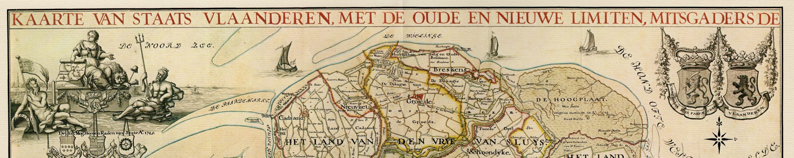
The military maps and town plans made during the time of the Dutch Republic (1579-1795) which form the subject of this study, were primarily made by military engineers in the service of the army of the seven provinces. Their job consisted both in the construction and maintenance of fortifications and lines of defence, and in carrying out siege-operations. In order to make available and adequate supply of well-educated engineers, a special course was introduced in 1600 at the University of Leiden, called “Duytsche Mathematicque” (Dutch applied mathematics). At about the same period, a standard measure the Rhineland rood (3.767 m, or ca. 4 yds) was introduced for use in all operations carried out on behalf of the army. The number of engineers increased from about ten in 1600, to about 18 towards the end of the Eighty Years’ War (ca. 1648). The success of the course “Duytsche Mathematicque” was of but brief duration: from 1640 its significance declined rapidly, till it finally expired in 1681. Just as at other universities in the Netherlands, this course proved unable to establish a central institute for the education of military engineers at university level. In about the mid-seventeenth century, France became the leading European country in the field of military sciences. The kingstadhouder William 111 (who with his wife Mary became joint sovereign of England in 1688), the great opponent of the French king Louis XIV, based his ideas on the organization of the defence of the Netherlands on what was happening in France. Following the French model, he placed a director-general in charge, and introduced a division into several departments each under the management of a director. For the purposes of waging war against the French, the number of engineers in service with the state army increased to eighty at the time of the War of the Spanish Succession (1701-1713). During this expansion, a large number of French were taken into service. At the time, the director was Menno van Coehoorn, the opposite number of the famous French fortification engineer Vauban. The Advances made in the field of fortification, persuaded the latter to introduce (within the corps of engineers) a high degree of specialization, including among other things a number of engineers known as “ingénieurs géographes” who from 1691 onward occupied themselves exclusively with the preparation of military maps. In the Republic, there was no comparable specialization, as yet. Factors that mediated against such a development, included the small size of the corps of engineers, and the lack of any powerful central organization. Under te capable management of the director-general Carel Diederik du Moulin (who occupied this position from 1774 to 1792), a small number of engineers was (from 1773 onwards) finally appointed to the task of preparing military maps. In their work, they continued to be troubled by the previously mentioned factors mediating against them. The diversity, which was characteristic for the organization and education of military engineers during the period of the Dutch Republic, is reflected in the maps made at the time. With regard to such fortification-plans (dating from the last twenty years of the sixteenth century, and from the seventeenth century) as have been preserved, we find that there was no uniformity of content, style or scale. A common feature was the strong emphasis on fortifications, accompanying a relative neglect of details of the internal topography of a town, and of the town’s surroundings. The towns which were mapped, lay almost exclusively in the defence lines on the frontiers of the Republic, and (within it) on the borders of the province of Holland.
The purpose for which the plans were made, was two-fold: they served as a guide for the design of fortifications to be constructed or improved or as an aid to their administration, inspection and maintenance or in the last resort during defence in time of war. For the latter purpose, special atlases began to be made towards the end of the Eighty Years’ War which included plans of all fortresses. But only in the time of the directorgeneral Menno van Coehoorn, was an order given for the systematic mapping of a large number of border fortresses. Although these plans have not survived, it is clear from the archives that attention was no longer confined to the fortifications alone, and that value was attached to the accurate representation of the topograhy of the surroundings of fortified towns. This development is also noticeable in such individual plans as have survived, scattered among different collections. Doubtless there was a connection with the increasing fire-power and trajectory of siege-artillery, and the necessity arising from it for measures around a fortified town for keeping the enemy at a sufficient distance. Coehoorn attached great importance, in this respect, to inundation as a means of defence.
The systematic mapping of fortified towns, which was carried out during the directorship of Coehoorn, found a successor in the 20’s and 30’s of the eighteenth century: in the excellently drawn, uniform plans which J.P. Prevost prepared to a 1:5,700 scale of the fortified towns in the Province of Holland, in which the increasing importance of an extensive and detailed knowledge of the surrounding terrain is once more emphasized. These plans excel in the fine and detailed mapping of a broad region, surrounding the fortification. In the extensive series of plans of Government fortifications made by various engineers from 1734-1737 at the behest of the Council of State (of the Netherlands), there is by contrast a lack of uniformity. Nevertheless, the seven atlases into which these plans have been bound, form an important milestone in urban cartography. During the period of the Republic, a comparable mapping (including all border fortresses) was never repeated.
With respect to the way in which plans were made in this period, a common characteristic is that an orthogonal projection was generally used. This means of representation lent itself most readily to the reproduction of fortifications. The vertical component, which was equally important for an adequate understanding of the construction, was indicated by means of profiles or sections, which in certain instances were drawnin on the relevant plan, or in other cases were drawn out on separate sheets. During the frequent use of plans for designing new fortifications, or making improvements in existing constructions, it was general practice to add the newly designed portions in dotted lines and/or in yellow colour. Other customary colours were red for walls and buildings; grey or black for other regions of embankment; blue (or sometimes dullgreen) for water; and green for vegetation.
It is evident that the progress in fortification is fully reflected in contemporary military topographic maps. Until the end of the seventeenth century, these maps were made both by military engineers and by land-surveyors, a fact that can best be explained by the relatively poor development of specialized military personnel in this field. In their manner of representation, there is as yet no difference between civil and military maps. Besides, in this period, only a few military maps were made: we may suppose that the need for them was relatively slight, with the methods of warfare then in use. The mapped areas consist almost always of lines of defence, more particularly of the waterfilled ditches which stretched along the rivers and through the polders and marshes on the frontiers of the Republic and the province of Holland. Until well into the seventeenth century, the rivier courses as such, were regarded as formidable barriers, but from the time of Menno van Coehoorn (towards the end of the seventeenth century), when inundation was used systematically and on a large scale, the regions to be put under water became much more extensive.
As far as can be ascertained, Coehoorn hardly made use of special maps for the designing of new lines-of-defence by water. Due to his rather rigorous approach (he didn’t hesitate from putting much more land under water than was strictly necessary, for the purposes of defence) he had little need of detailed topographical knowledge. The crude inundations carried out during the War of the Spanish Succession were not sufficiently effective, did unnecessary damage and met with resistance among local populations. Such experiences formed the stimulus for ensuring that subsequent inundations were not more extensive than was strictly,necessary, but still retained their full effect. To ensure such a result, one needed a better knowledge of the terrain. Topographical maps, accompanied by descriptive reports have been essential equipment since this period. The most important elements which received attention in such maps, included hydrographic information, the relief of the terrain, the land usage and the population. In a number of the maps that have survived, their increasing importance is clearly expressed: following the small number of maps in the seventeenth century (about 44, of which 34 are originals) the numbers from the eighteenth century are considerably greater (about 404, some 172 of which are originals). With town plans, the proportions are different: a total of 145 prior to 1715, of which about 115 are original, as against ca. 698 after 1715, of which about 290 are original.
The direct result of these new developments are the maps of Pieter de la Rive (who mapped the districts of Westerwolde and the River Vecht in the Overijssel region, 1717-1730), Bernard Jacob de Roy (who mapped the Gelderse Vallei 17411744), and Cornelis Draeck (who mapped North Brabant 1739-1744). The improved differentiation of the mapping, necessary for a more accurate representation of the topography in order to achieve more subtle inundations, was made possible (among other things) by using a larger scale, (never less than 1:25,000). In addition, an entirely new system of symbols came into fashion, probably derived from the French “ing@nicurs g6ographes”. In spite of that, the maps of this period still tend to be rather crude and inaccurate. This was partly related to the incidental nature of military map-making: the work was seldom carried out according to a previously determined plan, but usually merely followed the requirements of the moment, which in many instances arose from the threat of war.
Already during the time of the War of Austrian Succession (1740-1748) the first signs of a new phase in military-cartography are noticeable. The use of military maps in the subsequent periods was not limited to forming schemes for inundation or plans for fortification. Due to recent developments in methods of waging war, armies no longer preoccupied themselves solely with attacking and defending fortified places, and began to manoeuvre with greater flexibility. Good maps had to ensure that an army commander in his tent (or study) could mark out the movements of his troops and units. In the years after 1773, various maps were made which met with these requirements. The cartographers were all assisted or taught by Johan Frederik Schouster, who may therefore be regarded as the originator of this method of map-making, something which he developed after extensive study, in particular of the most recent developments in France. These maps represent the undisputed climax of military cartography during the period of the Dutch Republic, to which Johan Hendrik Hottinger was much the most skilled and active contributor.
Following the conquest of the Northern Netherlands by French armies in 1795, a new period began in a number of ways. Thanks to a new and centralized form of government, unproductive particularism was brought to an end. Because of this, a number of projects which Du Moulin had sought in vain to accomplish in the previous period, could now be realized: the setting up of a school for military engineers and the formation of a corps of seven ‘ing6nieurs g6ographes”. In addition, people worked purposefully towards a uniform series of maps of the entire country.
A particular aspect of military cartography in the eighteenth century is the frequent occurence of copies and compilations. Since military maps were subject to strict secrecy and could not be published, geographical information (even for engineers themselves) was not readily accessible. For their own use, military personnel frequently made copies of existing maps. At least half of all existing maps and town plans consists of copies or second-generation maps. Of necessity, use was also made of printed maps which were then commercially available. From this material (of variable quality) new compilation maps were frequently put together.
The frequent occurence of copies and compilations has consequences for the present-day user of such maps. In the first place, mistakes inevitably crept in during copying and contribute to a reduction in accuracy of the mapping. The same is true when, during compilation, details from different epochs are combined to form a single new map. This carries with it the risk that one may attribute to all the data, actually derived from a variety of maps of quite different periods, the single uniform dating of the newly prepared compilation, from which in consequence historically unjustified conclusions may be drawn.
From a study of the military maps in the period of the Dutch Republic, it appears once more that it is essential to recognize both the origins and purpose of a map, before using information derived from it for the purposes of historical research. Further, prior to evaluation and using the information, it is most important to consult the relevant archive material.
In addition to describing the origin of the maps and town plans and the background factors which played a role in their formation, this book also includes a list with biographical and bibliographical details concerning the makers of military maps. There is also a systematic list of all the military maps and town plans of the Netherlands known in this period. The topographical maps which have proved most valuable for historico-geographical research are summarized in the form of a chart which also indicates page references.
Translation from the Dutch by dr. C.M.H. Harrison