27th International Conference on the History of Cartography
27.o Congresso Internacional de História da Cartografia
9-14 July 2017 Belo Horizonte
 ICHC 2017 was organized by the Universidade Federal de Minas Gerais, the Government of Minas Gerais, the city of Belo Horizonte, Circuito Praça da Liberdade (Centro Cultural Banco do Brasil, Casa Fiat de Cultura, Espaço do Conhecimento UFMG and Espaço Cultura MTC), CAPES, CNPq and FAPEMIG, and Imago Mundi Ltd.
ICHC 2017 took place within or close to Liberty Square, the 19th-century administrative centre, which is now dedicated to culture. The paper and poster sessions will be housed in the up-to-date facilities of the Centro Cultural do Minas Tênis Clube / the Cultural Centre of the Minas Tennis Club, located at Rua da Bahia 2244. The Centre has a very modern and well equipped auditorium with room for 600 people and was opened in 2013. Sessions were held in the Bradesco theatre and the Multimeios Auditorium, and the poster session in the Ballroom, all in the Minas Tennis Club.
The official language of the conference was English.
The organizing Committee:
- Júnia Ferreira Furtado (Professor of Modern History, Universidade Federal de Minas Gerais/UFMG) – President
- Maria do Carmo Andrade Gomes (History Researcher, Fundação João Pinheiro)
- Thais Pimentel (Professor of Brazilian History, Universidade Federal de Minas Gerais/UFMG)
- Iris Kantor (Professor of Modern History, Universidade de São Paulo/USP)
- Andrea Dore (Professor of Modern History, Universidade Federal do Paraná/UFPR)
- Rene Lommez (Professor of Museology,Universidade Federal de Minas Gerais/UFMG)
Assistants: - Valquiria Ferreira da Silva (History PHD student, Universidade Federal de Minas Gerais/UFMG)
- Carmem Marques Rodrigues (History Master student,Universidade Federal de Minas Gerais/UFMG)
The opening ceremony was held in the auditorium on Sunday 9 July and a key note Brazil and the cartographic challenge of the new by Junia Furtado (UFMG – Universidade Federal de Minas Gerais/ Brazil), and between the speeches Latin American Dances Variations by Bruno Castro and Robertinha Bastos.
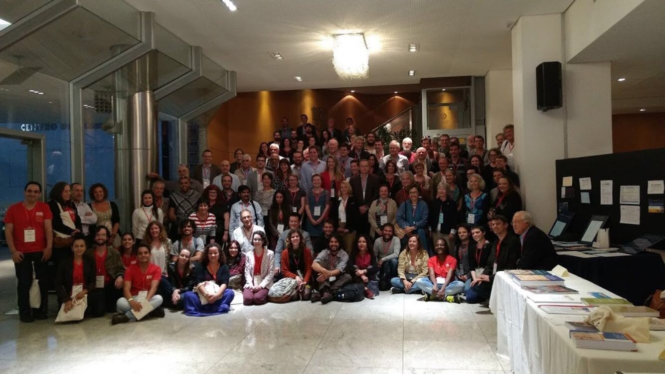
A total of 156 people attended the conference. Photos and biographical information each presenter and abstracts of all papers in English were provided in a printed program, and all participents were presented a boo The Cartographic Challenge of the New, edited by Junia Ferreira Furtado and Valquiria Ferreira da Silva, which included several essays and the lists of exposed maps and documents at the three expositions.
Pre-conference meetings included the Annual General Meeting of the International Society for the History of the Map (ISHMap) on Saturday 8 July and the Meeting of the International Society of Curators of Early Maps (ISCEM) on Sunday morning 9 July.
The farewell dinner was in the Museu de Arte da Pampulha.
The one-day pre-conference tour was a touristic tour through Belo Horizonte (Praça da Liberdade, Mangabeiras Viewpont and Conjunto Moderno da Pampulha / Pampulha Modern Architectural Complex).
The two day post-conference tour went on Saturday to Ouro Preto, overnight there and on Sunday to Inhotim Contemporary Art Museum.
Conference theme
The Cartographic Challenge of the New / O desafio cartográfico do Novo
Exhibitions
Three exhibitions were prepared in conjunction with the conference:
Museu Mineiro – Cartografar, pintar e desenhar Minas Gerais / Mapping, painting and delineating Minas Gerais
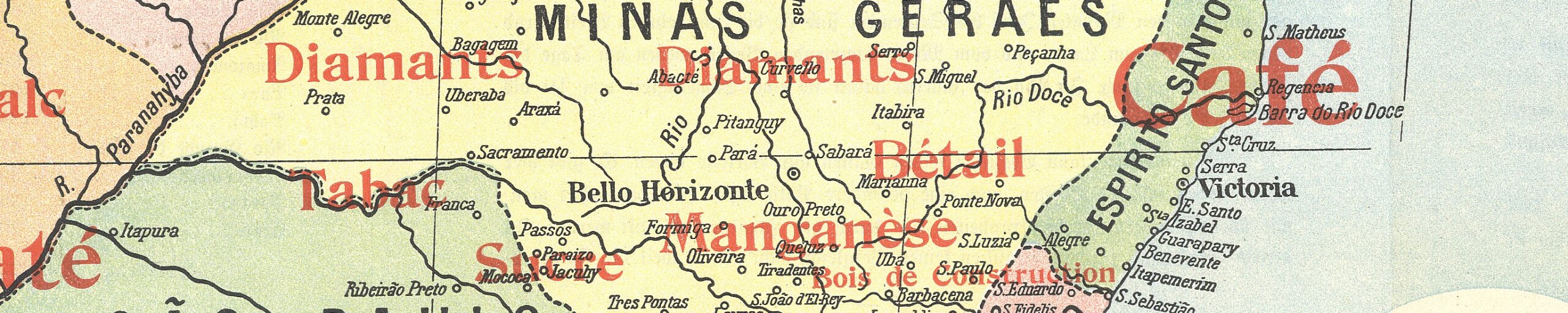
Displaying the cartographic evolution of the representation of Minas Gerais, from captaincy to province, during the 18th and 19th centuries. The region’s transformation was recorded on manuscript maps, showing the dynamics of its territorial expansion and growing population (from the centre outwards). Three separate areas evolved: the gold region (centre), the diamond region (northeast), and the backlands, still occupied by the Indians (east and west).
Centro Cultural do Minas Tênis Clube – Olhares sobre o globo: o desafio cartográfico do novo / Looking over the globe: The new cartographic challenge
The Brazilian National Library grew out of the collection that King Dom João [John] VI brought to Brazil when the Portuguese royal family fled to South America after the invasion of Portugal by Napoleon’s troops. Among the items saved is an illuminated manuscript of Ptolemy’s Geography. The Cartography division will display a representative sample of both precious and little known items from that collection, both manuscript and printed. These illustrate how the Portuguese represented their empire in maps.
Museu Histórico Abílio Barreto – Belo Horizonte: uma cidade planejada nos trópicos / Belo Horizonte: a planned city in the tropics
This exhibition features the collection of visual and cartographic representations (maps, panoramas, and blueprints of public and private constructions) from the period of the creation of the city of Belo Horizonte. The material belonged formerly to the committee charged with building the city and is now owned by the Abílio Barreto Historical Museum and the city archive.
The MHAB is part of the Municipal Foundation of Culture of the Municipality of Belo Horizonte. Its origins date back to 1935 when the journalist and writer Abilio Barreto was invited to organize the General Archive of the City Hall. He began collecting documents and objects for a future city museum of history, concentrating on two aspects: the former Curral Del Rei village and parts for the new capital (Belo Horizonte city). The house of the former Leitão farm, part of the museum, is the only architectural remnant of the surroundings of the Curral Del Rei village.
Papers
* = not read, abstract in program book.
NB: Sessions Bn were in the Bradesco Theater, and sessions Mn in the Multimeios Auditorium.
Extraordinary sessions:
- B1 was the opening session
- M11 the poster session
- B14 the History of Cartography Project
- B21 Prospects for the History of Cartography: A Conversation. Chair Karen Pinto),
Panelists: Carla Lois, Kären Wigen, Jordana Dym, James Akerman, Matthew Edney, Chet Van Duzer - B22 the Closing Ceremony.
Session B2: City pictura and description. Chair: Peter Barber
- Colin Dupont (BE). Creating vision? The case of the city maps of Jacob van Deventer (sixteenth-century.
- Wojciech Iwańczak (PL). Images of towns in early cartography.
- Daniela Marzola Fialho and Jezabel Neubaeur Katz (BR). A commercial plan of Porto Alegre (RS), Brazil.
Session B3: Mapping the waters: oceans and seas. Chair Cláudia Damasceno
- Zef Segal (IL). From sea voyages to global wars: The iconography of movement in European and American atlases (1837-1914).
- Kaan Üçsu (TR). Ibrahim Müteferrika’s map of the Black Sea and its copies in Bibliothèque national de France.
- Yannan Ding (CN.GB). Updating sea charts: (Re-)discoveries in the Naval Chronicle (1799-1818).
Session M3: Mapping nationhood. Chair Eloi Ficquet
- Renato Amado Peixoto (BR). ‘I make known the end from the beginning’: Jaime Cortesão’s courses at the Ministry of Foreign Affairs and the processes of producing historical atlases in Brazil.
- Tarun Kumar Mondal (IN). The Great Trigonometrical Survey in colonial India (1799-1866) and the imagination of Indian nationhood.
- Caio Figueiredo Fernandes Adan (BR). The measure of the world: ‘Comarca’ as a category of special representation in the early modern Iberoamerican world.
Session B4: Mapping in the Middle Age. Chair Francis Herbert
- Zokirjon Saidboboev (UZ). Certain aspects of al-Kharezmi’s mapping (on the basis of the ‘Surat al-arz’).
- Karen Pinto (US). Understanding Historically the Distribution of Places on Medieval Islamic Maps of the Mediterranean.
- Chet Van Duzer (US). How to draw the world: The mappaemundi of Guillaume de Saint-Cloud.
- Joaquim Alves Gaspar (PT). The ‘Liber de existencia riveriarum’ (c.1200) and the birth of nautical cartography.
Session M4: Collecting war. Chair Mirela Altic
- Sunyoung Park (KR). Fatal panic: Military secret maps and Soviet-Japanese relations in Manchuria.
- Petra Svatek (AT). The cartographic construction of Europe during World War I at the University of Vienna.
- Martijn Storms (NL). Collecting from cutting to copying: Brazil in the Bodel Nijenhuis collection.
- Bram Vannieuwenhuyze and Martijn Storms (NL). The liberation of Salvador da Bahia (Brazil, 1625) in brilliant disguise: Some reflections upon recycled and camouflaged maps.
Session B5: Cities and urbanism. Chair Mary Pedley
- Catherine E. Burdick (CL). Revealing peripheral urban places in the Spanish colonial world through cartography: rendering the Convent of the Discalced Carmelites of Saint Raphael, La Chimba, Santiago, 1773.
- *Anthony Mullan (US). Creating urban spaces on the frontier of the Spanish empire: Galveztown, Louisiana (1779) and Nueva Orán, Argentina (1794).
- Kory Olson (US). Léon Jaussely’s 1919 Plan d’extension (de Paris): Proposing a modern capital city
- Michael Heffernan (GB). The scale of two cities: Mapping the dimensions of London and Paris in the 1720s.
Session M5: Indigenous and native mapping. Chair Jörn Seemann
- Amalia Cristovão dos Santos (BR). Mapping the ‘sertão’: The significance of the presence and absence of indigenous populations on the cartography of Portuguese America.
- Benjamin Olshin (US). Indigenous mapping: Culture creates cartography.
- Alexey Postnikov (RU). Prince Peter Kropotkin’s service in the Amur Cossack Army and his use of cartographic information from indigenous informants (1862-1867).
- Fátima Irasema Martínez Reyes (MX). Reading the landscape of San Pedro Teozacoalco, Oaxaca, México, from the codex ‘Mapa de Teozacoalco’ (1580): A cultural approach.
Session B6: Missionary maps and sacred places. Chair Sebastian Diaz Angel
- Mirela Altic (HR). Mapping a tropical frontier: Cartography of the Jesuit province of Moxos.
- Carme Montaner (ES). Franciscan cartography of the Peruvian Amazon in the second half of the eighteenth century.
- Ariel Tishby (IL). Sacred geography and sacred architecture in an unknown manuscript map by Paolo Luigi Gozzi, 1777.
Session M6: Voyages and mapping. Chair Jordana Dym
- Katherine Parker (GB). Visualizing the voyage: Cartographic print and material culture of the Anson expedition (1740-44) from the eighteenth to the twentieth centuries.
- *Olga Okuneva (RU). Information that travels from map to map: The transfer of knowledge from the books of French travelers to Brazil to European maps of the New World (late sixteenth-seventeenth century).
- Denise Aparecida Soares de Moura (BR). Francesco Tosi Colombina’s 1756 map and river routes in the Tibagy hinterland.
Session B7: Enigmatic cartographies. Chair Joaquim Alves Gaspar
- Sabrina Guerra Moscoso (EC). Caribana and Nova Albión: Geographical enigmas at the brink of the Spanish Empire.
- Jeremy Brown (GB). Mapping Rome’s Isola Tiberina: Ancient history, papal politics, and Pirro Ligorio’s vision.
- Brenda Degger (BR). The Lord of the Rings’ map and the construction of a fantastic world.
Session M7: Mapping nationhood: Measuring Ethiopia (OR) geopolitics and maps in Africa. Chair Michael Heffernan
- Fesseha Berhe (FR). Examining the developments of the Highland-Lowland territorial concepts in Northern Ethiopia.
- Wolbert Smidt (ET). A new reading of old maps of northeastern Africa: Sources for local territorial, socio-political, and cultural concepts.
- Eloi Ficquet (FR). Of math and men: The multi-layered methodology of Antoine d’Abbadie’s maps of Ethiopia published in the 1860s.
Session B8: Historical maps in the age of digital tools. Chair André Reyes Novaes
- Ian Fowler and Kristen Gwinn-Becker (US). Project MAPPY: Towards a holistic understanding of the history of cartography.
- Evan Thornberry (US). Increasing access to maps of the American Revolutionary War era through digital tools and institutional collaboration.
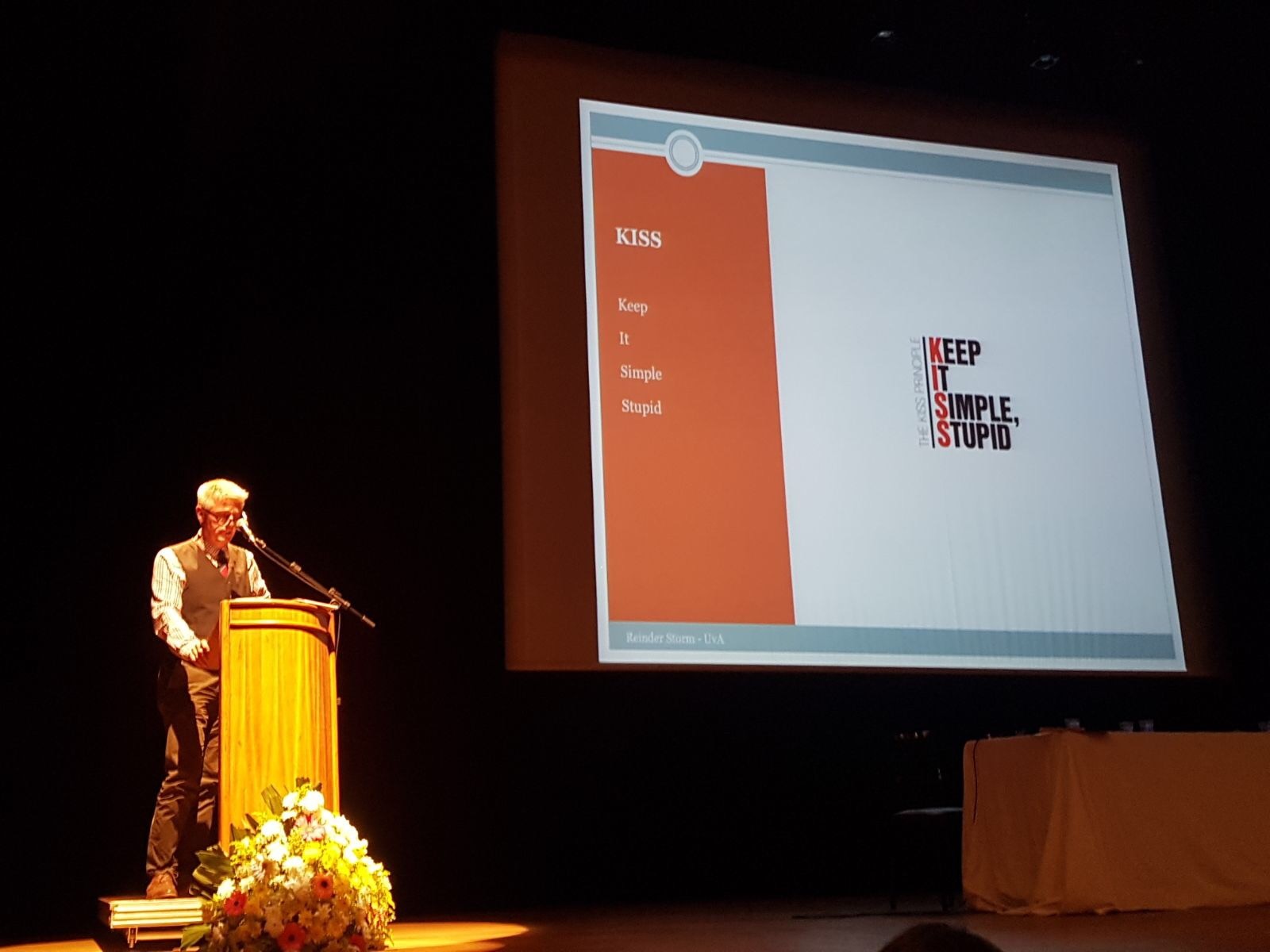
- Reinder Storm (NL). What else do we need? Presenting digitized historical map collections in the Netherlands.
- Leif Isaksen (GB). Pelagios Commons and the Tabula Peutingeriana.
Session M8: Politics, nation and nationalism. Chair Roger Kain
- Sen-hao Yang (TW). Spatial cognition between (pre)modern regimes: A case study of North Taiwan (1785-1910).
- Carla Sales (BR). Dictatorship and art: The maps of Horacio Zabala in the Argentine military regime.
- José Rogério Beier (BR). Maps and politics: The São Paulo Provincial Legislative Assembly and its project of territorial construction during the Regency period (1831-1840).
- Megan Barford (GB). Bureaucracy, cartography, and the Hydrographic Office of the British Admiralty, 1825-1855.
Session B9: Travel accounts, narratives and people. Chair Carla Lois
- Jordana Dym (US). Nineteenth-century travelers’ maps: Following the trail from sketch to publication.
- James Akerman (US). The lost nineteenth-century American road map: Rehabilitating an overlooked genre.
- Iris Kantor (BR). The South Atlantic slave trade in eighteenth- and nineteenth-century cartography.
- Pablo Castro (CO). The 1919 geological sketch of Southern Antioquia by Robert Scheibe: A vantage from which to see German cartographic influences on the development of geology in Colombia in the early twentieth century.
Session B10: Illusions, accuracy and dimensions. Chair Matthew Edney
- David Weimer (US). Look but don’t touch: Cartographic illusions of tactility.
- Graciela Favelukes and Malena Mazzitelli Mastricchio (AR). The journeys of the vertical dimension: Altitude mapping as statecraft in nation making (Argentina, 1901-1914).
- *Zsolt Török (HU). In the shadow of Enlightenment: Geometric accuracy, thematic content, use of maps, and Marsigli’s cartography.
-
Session M10: Indigenous mapping in Americas. Chair David Palacios
- Artur Henrique Franco Barcelos (BR). Guarani cartography as an instrument of autonomy.
- Daniel Shelley (US). The Taino portolan: Pre-Columbian cartography of the Caribbean.
Session B12: Early Modern cartography: people, lands and aeter. Chair Neil Safier
- Robert J. King (AU). Reliqua australis orae etiamnum in obscuro latent: Hidden yet in obscurity, the southern lands on sixteenth-century world maps.
- Ruth Watson (NZ). Apocalypse redux: The toponym of enclosed Jews in early modern cartography.
- Nydia Pineda De Avila (GB). Circulation and Collection of Selenographic Knowledge in the 17th Century.
- Daniel Ruppel (US). Pictorial citations in Pierre Descelier’s mappamundi (1553) and the “Figure des Brazilians”: Painterly imitation, political implications, performative complications.
Session B13: Where was Asia in the Early Modern period?. Chair Iris Kantor
- Kären Wigen (US). Where was Asia in the Early Modern period? Perspectives from Japan.
- Charlotta Forss (SE). Where was Asia in the Early Modern period? Perspectives from Northern Europe.
- Lisa Hellman (JP). Where was Asia in the Early Modern period? Asia in China, Russia and the in-between: perspectives from Central Asia.
Session B15: Imaginary and desired hydrography in the Americas. Chair James Akerman
- Quentin Morcrette (FR). Imagining water in the desert, a late example in the American Great Plains.
- Sebastian Diaz Angel (US). A ‘South American Great Lakes System’: Cartographies of a geographical engineering program in Latin America to contain Communism.
- Jörn Seemann (US). Rivers of doubt: Naming practices, narrative cartographies, and textual geographies of the Amazon and its tributaries in the early twentieth century.
Session B16: Merging scales and representations. Chair Carme Montaner
- Matthew Edney (US). A game of snakes and ladders: The elusive history of “map scale”.
- Mauricio Onetto (CL). A world-passage at different scales: The Strait of Magellan as a constructor of territoriality in the sixteenth century.
- Andréa Doré (BR). Choosing scales: Space and time in Michaele Colinio’s map (ca. 1620).
- Andres Velez Posada (CO). Pilgrimage in the Andean valleys: Cosmographical and historical scales in the ‘Carta corografica’ related to Juan de Castellano’s chronicle (1589-1601).
Session B17: Mapping the waters: Rivers and hydrography. Chair Andrea Doré
- Federico Ferretti (IE). Mapping Amazonia: The cartographic work of the explorers Henri and Octavie Coudreau and their collaboration with Elisée Reclus (1882-1906).
- Sebastian Gomez (CO). The mapping of the Putumayo River and the Luso-Hispanic struggle in the Amazon Basin during the eighteenth century.
- Patricia Aranha (BR). Mapping an Amazon river: The case of Ikê.
- David Alejandro Ramirez Palacios (MX). The president and the Cartographerc Rafael Reyes, Vergara y Velasco, and the Colombian National and Putumayo River Maps.
Session B18: Entangling systems of knowledge: Japan and China. Chair Kären Wigen
- Vera Dorofeeva-Lichtmann (FR). The first printed European map of China (Ortelius 1584): Confusions over its authorial attribution (Luis Jorge de Barbuda, fl. 1575-1599?) and traces of Chinese cartographic influence.
- Angelo Cattaneo (PT). Transcultural exchange on a recently discovered, seventeenth-century Japanese cartographic folding screen.
- Radu Leca (NL). Cannibals on European and Japanese maps of South America: An intriguing case of iconographic dissemination.
Session B19: Mapping America. Chair Markus Heinz
- Carolina Martínez (AR). Translating travel narratives into cartographic images: Representations of America in Guillaume Le Testu’s Cosmographie Universelle (1556).
- Wolfram Dolz (DE). The dominant depiction of South America on the brass globes of 1566 and 1568 by Johannes Praetorius: A major leap in the cartographic representation of the New World as manifested in the globes held by the Germanisches Nationalmuseum (Nuremberg) and the Mathematisch-Physikalischer Salon (Dresden).
- Alexander Sievers (DE). Maps as commodities: The economic history of Heinrich Berghaus’s ‘Chart of the World’.
Session B20: Theoretical aspects of the History of Cartography: Twenty years later. Chair Ed Dahl
- André Reyes Novaes (BR). On alternative concepts of time in the history of cartography.
- Carla Lois (AR). Renewing the debate about theoretical frameworks, conceptual networks, and methodological approaches in maps and mapping history.
Poster Presentations, Wednesday 12 July
- Enali de Biaggi and Virginie Chasles (FR)/ Mapping the city through its hospital: The Hôtel Dieu in Lyon (France).
- Bárbara Polo Martín (ES). Fortification projects in Burgos (Spain), 1834-1858.
- Mary Pedley (US). Eighteenth-century cartography in two maps: The cover illustrations for Volume Four of The History of Cartography.
- Valquiria Ferreira da Silva (BR). “Extracted from the original”: Art, science, and technique on the map of Portuguese America by Father Cocleo.
- Friedrich Renger and Maria do Carmo Andrade Gomes (BR). German cartographers in nineteenth-century Minas Gerais, Brazil.
- Uilton dos Santos Oliveira and Maria Dulce de Faria (BR). The Branco River maps surveyed for the Santo Ildefonso Treaty in the Biblioteca Nacional, Brazil.
- Rildo Borges Duarte (BR). Project for a country project: Brazil’s first republican map.
- *Wang Yifan and Jiajing Zhang (CN). A study of topographic surveying and mapping of the Lower Yangtzi Region in the early Tongzhi period.
- *Larissa de Carvalho Nascimento (BR). The representation and the construction of the Urban and Urbanity in the work of Anhaia Mello and Prestes Maia (1918-1934).
- Guillermo Arturo Medina (CO). Surveying and selling: Cadastral maps and land development in the Windward Islands (1764-1776).
- Sabrina Mota Marcondes (BR). How the heavens were invaded: Religion and science in the atlas Coelum Stellatum Christianum.
- Lucas Montalvão Rabelo and Luciana de Queiroz Pinto (BR). Indigenous populations of the New World in European renaissance cartography: The case of Sebastian Cabot’s world map (1544) and Diogo Homem’s map of South America (1558).
- Dániel Zoltán Segyevy (DE). A special way of the ethnolinguistic cartography: The application of the isoline method in the Hungary Atlas of the Naval Intelligence Division of British Admiralty (1919).
- Luciano Zoboli and Fernando Padavesi Fonseca (BR). Mobility in São Paulo in the first half of the twentieth-century: A geo-historical approach.
- Thomas Horst and João Carlos Garcia (PT). Discovering and analysing early Portuguese cartography in Germany (1778-1884).
- Mario Cams (MO). Eighteenth-century Qing imperial cartography and its European connection.
- Carmem Marques Rodrigues (BR). Minas Gerais captaincy on the Colombia Prima map: a comparative study of cartographic sources.
- Rafael Lara Mazoni Andrade (BR). Geodesign, innovation and Geography in Brazil: a discussion on epistemology and paradigms and an effort to list and characterize the Brazilian production.
- Lena Denis (US). ‘Where Pirates and Cannibals Meet: Exploring Colonial Brazil.
Reports
Imago Mundi 70,1 (2018), 114-119 (Jeremy Brown and Charlotta Fors)
The Portolan 100 (Winter 2017), 64-67 (Bert Johnson et al.)