3rd International Conference on the History of Cartography
3e Internationale Conferentie over de Geschiedenis van de Cartografie
3ème Congrès international d’histoire de la cartographie
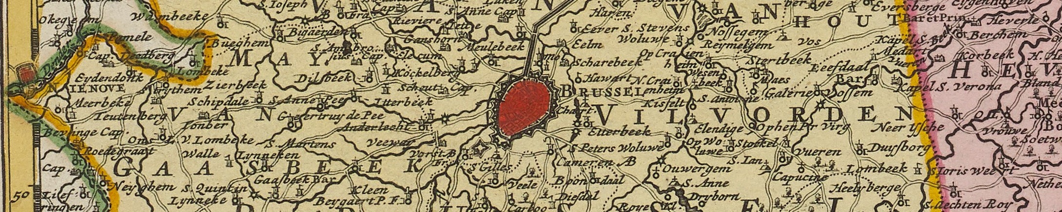
17-20 September 1969 — Brussel/Bruxelles [Brussels]
 The first to be called at the time “International Conference on the History of Cartography”. Held in Albert I Library in honor of death of Belgian cartographer Philippe Vander Maelen, simultaneously with 3rd International Symposium of the “Coronelli World Union of Friends of the Globe”. Principal cordinators were Antoine de Smet, L. Wellens-De Donder, Eila Campbell, Cornelis Koeman, and Ernst Bernleithner. Attendance was “more than 140,” from 20 countries. (A full list of the participants of the double congress is in Der Globusfreund 18-20 (1969-71): 17-20.) Conference languages were English, French, Dutch, German.
There was but one broad theme, “The mapmaker’s craft; technique and science of cartography till 1870.”
In the Royal Albert I Library was an exhibition on the life and works of Vander Maelen (catalog: L. Wellens-De Donder, and A. de Smet, Philippe Vandermaelen 1795-1869. Catalogue de l’exposition (Bruxelles, 1969)(63pp), also in a Dutch edition); and there was an excursion to Antwerp, including a visit to the Plantijn-Moretus Museum.
There were in all 20 papers, 14 of which were read. Probaly full sets of papers were distributed as at the previous conference, although I have not seen this stated, and a 50-page booklet of abstracts was published (see Bibliotheca Cartographica, 25 (1969), no. 288). Of the papers, nine (not ten) were published full in Imago Mundi 24 (1970) (Burmeister, Chang, Dainville, Destombes, Gilbert de Cauwer, Grenacher, Osley, Skelton, Woodward), and five more in abstract there (Bernleithner, Kirmse, Smith, Talbot, Waters). Interestingly, we learn from one of the first published reports of the conference, that, at the close of the conference the meeting place for the next had still not been decided (Grenacher, p. 25b).
Papers 3rd ICHC
- Arnould, Maurice-A. L’originalité du travail cartographique de Ferraris dans les Pays-Bas autrichiens.
- Bernleithner, Ernst. Österreichs Anteil an der Weltkartographie.
- Burmeister, Karl Heinz. Achilles Pirmin Gasser (1505-1577) als Geograph und Kartograph.
- Campbell, Eila. Configuration of the North American Coastline on Fifteenth and Early Sixteenth Century Charts and Maps.
- Chang, Kuei-Sheng. Africa and the Indian Ocean in Chinese Maps of the Fourteenth and Fifteenth Centuries.
- Dainville, F. de. How Did Oronce Finé Draw his Large Map of France?
- Destombes, Marcel An Antwerp Unicum: An Unpublished Terrestrial Globe of the XVI Century in the Bibliothèque Nationale, Paris.
- Gilbert de Cauwer, Eugene. L’établissement géographique de Bruxelles, fondé en 1830 par Philippe Vandermaelen.
- Goldstein, T. E. The New Concept of the Earth in its Importance for the Scientific Revolution. (Although in the program, this paper was perhaps not read(?).)
- Grenacher, Franz. Die holzgeschnittene Landkarte; ein Kartenformschneider des 1. Viertels des 16. Jahrhunderts geistert durch Europa.
- Kirmse, Rolf. Gerhard Mercator und Christian Sgroten. Ihre Werkstätten und ihr politischer Engagement.
- Lemoine-Isabeau, Claire. Le plan de Bruxelles par Lefèbvre d’Archambault et la cartographie bruxelloise au XVIIIe siecle.
- Mazaheri, Aly. L’origine de la constellation libra.
- Osley, Arthur. Calligraphy–A Cartographic Tool?
- Skelton, Raleigh Ashlin. The Military Surveyor’s Contribution to British Cartography in the 16th Century.
- Smet, Antoine de. Philippe Vandermaelen in de evolutie van de kartografie.
- Smith, Thomas R. Nicholas Comberford, Seventeenth-Century Chart-Maker at the “Signe of the Platt” in Ratcliff.
- Stanley, William R. Nineteenth Century Field Reconnaissance in Liberia: Fact or Fiction?
- Talbot, Henry Dennis. The Chinese World Map of 1593.
- Waters, David Watkin. Pilot Books and Waggoners in English in the Early 17th Century.
- Woodward, David. Some Evidence for the Use of Stereotyping on Peter Apian’s World Map of 1530.
Rerefences
Imago Mundi 24 (1970): 10 (Koeman)
L’Universo 49 (1969): 1153-54 (Monaco)
Kartographische Nachrichten 20 (1973): 24-25 (Grenacher)
Der Globusfreund 18-20 (1969-71): 16-20 (Bernleithner)
Cartographic Journal 6 (1969): 86 (Jeacock)
Polski przegląd kartograficzny 42 (1970): 166-67 (Babicz)